


« Prev Next »
Introduction
The way in which we develop the American landscape and its urban areas is a critical component to creating livable and sustainable cities. The footprint of major metropolitan areas, suburbs, and small towns ultimately shapes the environmental and social conditions within our communities. One type of development pattern that has received increasing attention by researchers and policy makers interested in fostering sustainable communities is called "sprawl." Sprawl is generally typified as low-density, haphazard development spiraling outward from urban centers (Burchell et al. 1998). For years, scientists have argued that sprawling urban and suburban development patterns are creating negative impacts including habitat fragmentation, water and air pollution, increased infrastructure costs, inequality, and social homogeneity (Ewing 1997; Squires 2002). Understanding the causes, consequences, and policy implications related to sprawl can provide important insights on how to construct more sustainable communities over the long term.
Characteristics of Sprawl
The phenomenon of sprawl has been described in various ways, ranging from development aesthetics to local street patterns (Galster et al., 2001). While there is no universally accepted definition of sprawling land development, there are several common characteristics pervading the literature that can help us understand and even measure its occurrence. These include:
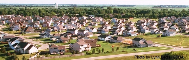
1) Low-density, single family dwellings. The most frequently cited feature of sprawl is the abundance of large-lot (usually 1-5 acres depending on the development context), residential housing developments that consume large amounts of previously vacant or productive land. Density, in this sense, can be represented by median lot size, the number of dwelling units per neighborhood, or median floor space of single-family units (Song & Knaap, 2004).
2) Automobile dependency even for short trip. Because sprawling development patterns create large distances between dwelling units and segregate different land uses, residents are forced to rely on automobiles at the expense of alternative forms of transportation. Also, the cul-de-sac dominated street patterns within these neighborhoods foster a lack of connectivity and serve as an obstacle for walking and biking to nearby destinations (Benfield et al., 1999). Reliance on the automobile also encourages the development of homogeneous neighborhoods that lack a mixture of land uses (Song & Knaap, 2004).
3) Spiraling growth outward from existing urban centers.Sprawl is also conceptualized as low-density development rapidly expanding away from more compact urban cores. Approximately 80 percent of the acreage used for recently constructed housing in the U.S. is land outside urban areas; almost all of this land (94%) is in lots of 1 acre or larger (Heimlich & Anderson, 2001).
4) Leapfrogging patterns of development. Another well-known characteristic of sprawl is dispersed development, which favors the development of parcels situated further out in the countryside over the vacant lands adjacent to existing development.(Torrens & Alberti 2000). Leapfrogging creates a haphazard development pattern that consumes large amounts of land.
5) Strip Development. "Ribbon" development, in which residences or commercial properties line roads extending outward from urban centers is another prominent characteristic of sprawl (Tsai, 2005). Homes arranged along rural highways present hazards related to traffic safety; commercial strips comprised of fast food chains and large retail stores cater to automobile access and are often fronted by expansive parking lots.
6) Undefined edge between urban and rural areas. Sprawling residential development extending outward from urban centers tends to blur the division between urban and rural domains (Heimlich & Anderson, 2001). This development pattern is often associated with the encroachment of open space and agricultural lands.
It is important to note that sprawling development patterns are tied to the context of the urban-suburban landscape. Low-density residential units may mean different things in the city of Houston than in a small town in coastal Maine. Also, one development project or neighborhood does not make for sprawl; rather, sprawling development must be assessed as an overall pattern at the regional level. as an overall pattern of development.
Causes
Sprawl is the result of a complex set of interrelated socioeconomic and cultural forces. Land value, however, is often considered the chief driver of development patterns. Sprawl tends to occur where property values are lower on the periphery of urban centers (Pendall, 1999). Economists identify three underlying forces that interact with land values to create spatial urban expansion or sprawl. First, population growth results in the outward expansion of urban areas (sometime population decline also can be a precursor to sprawl). Second, rising incomes allow residents to purchase larger living space. These residents locate where housing options are less expensive, in suburban and ex-urban areas generally located at the outskirts of metropolitan areas (Carruthers & Ulfarsson 2002). Third, decreasing commuting costs produced by historical investments in transportation infrastructure also fuel outward expansion of development (Brueckner, 2000). Infrastructure drives the growth of cities by providing the essential framework for residential development. After new development takes place, residents then demand improvements in infrastructure that further ignites development along the urban fringe. Widespread access, provided by improvements in transportation infrastructure and relatively inexpensive gas prices, allows developers to utilize cheap land located outside the city center (Gillham, 2002).
Race has been identified as another socioeconomic indicator of urban and suburban sprawl. Racial strife in the centers of cities such as Los Angeles and Detroit led to an out-migration of middle- and upper-class whites to the urban fringe (Daniels, 1999). This relocation of residents, known as "white-flight" can lead to more spread-out metropolitan areas and lower property values (Carruthers, 2003). Age has also been considered an important factor in determining the spatial pattern of development. Specifically, younger families promote sprawl and patterns by seeking out affordable housing options at the urban fringe (Zhang, 2001). Finally, it should not be overlooked that even though sprawl may be an unsustainable form of growth, people strongly prefer to live on larger lots in suburban communities. The American dream of homeownership usually involves a large yard in a newer, low-density neighborhood.
Consequences
While the literature identifies various social and economic consequences associated with urban sprawl, this article focuses on environmental problems. These negative impacts include, among others, air pollution resulting from automobile dependency, water pollution caused in part by increases in impervious surfaces, the loss or disruption of environmentally sensitive areas, such as critical natural habitats (e.g., wetlands, wildlife corridors), reductions in open space, increased flood risks, and overall reductions in quality of life (Kenworthy & Laube, 1999; Hirschhorn, 2001; Kahn, 2000).
More specifically, the reliance on automobiles has contributed to reductions in air and water quality as well as the accelerated depletion of fossil fuels (Nechyba & Walsh, 2004). In the United States, the number of motor vehicles has significantly outpaced population growth, and car owners are driving longer distances than ever before (Dunphy, 1997; Daniels, 2001).
Land is being consumed at a faster rate as populations shift from urban areas to suburban fringes (Porter, 2000; Kahn, 2000; Dwyer and Childs, 2004). For example, between 1950 and 1995, the population of Chicago grew by 48 percent, while land coverage increased by 165 percent (Openlands Project, 1998). Similarly, in the sprawling region southeast of Boston, more land has been developed in the last 40 years than in the preceding 330 years (Southeastern Regional Planning and Economic Development District, 1999). Sprawl associated with rapid population growth is nowhere more apparent than in south Florida, where the percentage change in urbanized land is among the highest in the country (Fulton et al., 2001). For example, Lang (2003) reported that out of 13 large U.S. office markets, South Florida has the lowest percentage of its office space in its major downtown (Miami). Only 13 percent of South Florida's office space is located in its central business district (CBD), compared with a median of nearly 30 percent for all 13 markets. Subdividing large natural areas into smaller spatial units can inhibit wildlife movement across the landscape (Peck 1998; Cieslewicz, 2002). Leapfrog development patterns further fragment natural landscapes by leaving patches of open land intermingled with built-up areas. Roadways, fences, and other abrupt, human-defined edges can act as barriers to wide-ranging species (Brody, 2008). These negative consequences of sprawl must be counterbalanced with the widely-held notion that this type of development pattern provides relatively affordable housing opportunities and a seemingly higher quality of life.
Sprawl Reduction Policies
While the causes and consequences of sprawl may seem daunting, there are multiple policies and techniques that can reduce the proliferation of unsustainable growth patterns. Local planning policies can help guide growth in a more ecologically sustainable fashion and assist local communities in attaining the intended spatial design and land use intensities. Specifically, planning policies and techniques can help concentrate growth within targeted areas, restrain development from sprawling uncontrollably into rural settings, and help protect or restore a region's natural resource base. Several terms are used to identify this type of development, including "smart growth," "compact development," and sometimes "new urbanism" (see Knaap & Talen, 2005).
Local decision makers can select from among several kinds of sprawl reduction policies. First, land development prescriptions, such as subdivision regulations, zoning provisions, building permit limits, and urban growth boundaries can prohibit or direct growth away from undesirable locations. Second, incentive-based techniques, including special taxing districts, clustering houses, development density bonuses, and transfer of development rights from rural to urban settings can encourage the containment of growth to areas within a central business district. Third, infrastructure-based policies, such as targeted public investments, capital improvements programming, phasing of development, and urban service areas can provide proactive approaches to guiding growth away from environmental sensitive areas. Fourth, land acquisition techniques, which range from fee-simple purchase of parcels to conservation easements, enable local governments to acquire and protect ecologically critical areas. Finally, educational and outreach programs aimed at helping a variety of audiences understand the adverse impacts of sprawl and the ways to mitigating it can also be of value. (Deurksen et al., 1997;Brody et al., 2006).
These policies, among others, can help reduce sprawl without compromising needed development. The end result is cleaner air and water, the protection of natural systems, lower infrastructure costs, and increased quality of life. It is important to note that in most cases, a single growth management policy is not enough to mitigate outwardly expanding development; it must be part of a broader program. Montgomery County, MD, for example, has enacted multiple strategies that work together to mitigate sprawl (Song, 2005).
References and Recommended Reading
Benfield, F. K. et al. Once there were green fields: How urban sprawl is undermining America's environment, economy and social fabric. (New York: Natural Resources Defense Council, 1999).
Brody, S. D. Ecosystem Planning in Florida: Solving Regional Problems through Local Decision Making. (Aldershot, UK: Ashgate Press, 2008).
Brody, S.D. et al. Measuring the adoption of local sprawl reduction planning policies in Florida. Journal of Planning Education and Research 25, 294-310 (2006).
Brueckner, J. K. Urban sprawl: diagnosis and remedies. International Regional Science Review 23, 160-171 (2000).
Burchell, R. W. et al. The costs of sprawl-revisited. Report 39. Transit Cooperative Research Program, Transportation Research Board. (Washington DC: National Academy Press, 1998).
Carruthers, J. I. Growth at the fringe: The influence of political fragmentation in United States metropolitan areas. Papers in Regional Science 82, 475-499 (2003).
Carruthers, J. I. & Ulfarsson, G. F. Fragmentation and sprawl: evidence from interregional analysis. Growth and Change 33, 312-340 (2002).
Cieslewicz, David J. The Environmental Impacts of Sprawl. In Urban Sprawl: Causes, Consequences and Policy Responses. ed. Squires, G. (Washington DC: The Urban Institute Press, 2002).
Daniel, T. When city and country collide: Managing growth in the metropolitan fringe. (Washington DC: Island Press, 1999).
Daniels, T. Smart Growth: A New American Approach to Regional Planning. Planning Practice & Research 16, 271-279 (2001).
Duerksen, C. Elliot, D. et al. Habitat Protection Planning: Where the Wild Things Are, APA Planning Advisory Report No. 470/471. (1997).
Dunphy, Robert T. et al. Moving Beyond Gridlock: Traffic and Development. (Washington, DC: The Urban Land Institute, 1997).
Dwyer, John F. & Childs, G. M. Movement of people Across the Landscape: A Blurring of Distinctions Between Areas, Interests, and Issues Affecting Natural Resource Management. Landscape and Urban Planning 69, 153-164 (2004).
Ewing, Reid. Is Los Angeles-style sprawl desirable? Journal of the American Planning Association 63, 107-126 (1997).
Fulton, W. et al. Who sprawls the most? How growth patterns differ Across the U.S. The Bookings Institution, Center on Urban and Metropolitan Policy, 2001. Available online at: .
Galster, G. et al. Wrestling sprawl to the ground: defining and measuring an elusive concept. Housing Policy Debate 12, 681-717 (2001).
Gillham, Oliver. The Limitless City: A Primer on the Urban Sprawl Debate. (Washington DC: Island Press, 2002).
Heimlich, Ralph E., & Anderson, W. D. Developing the urban fringe and beyond: impacts on agriculture and rural land. Report Number 803. (USDA Economic Research Service: Washington, DC, 2001).
Hirschhorn, Joel S. Environment, quality of life, and urban growth in the new economy. Environmental Quality Management 10, 1-8 (2001).
Kahn, Matthew E. The environmental impact of suburbanization. Journal of Policy Analysis and Management 19, 569-586 (2000).
Nechyba, T. & Walsh, R. Urban sprawl. Journal of Economic Perspectives 18, 177-200 (2004).
Knaap, G. & Talen, E. New urbanism and smart growth: a few words from the academy. International Regional Science Review 28, 107-118 (2005).
Lang, R. Beyond edge city: office sprawl in south Florida. The Brookings Institution — Survey Series Center on Urban and Metropolitan Policy. ( 2003).
Openlands Project. Losing ground: land consumption in the Chicago region, 1990-1998. (Chicago: Openlands Project, 1998).
Peck, S. Planning for Biodiversity: Issues and Examples. (Washington DC: Island Press, 1998).
Pendall, R. Do land use controls cause sprawl? Environment and Planning B 26, 555-571 (1999).
Porter, Douglas R. et al. The practice of sustainable development. (Washington DC: Urban Land Institute, 2000).
Southeastern Regional Planning and Economic Development District. Southeastern Massachusetts: Vision 2020 an Aagenda for the future. (Taunton, MA: Southeastern Regional Planning and Economic Development District, 1999).
Squires,
Gregory D. Urban Sprawl and Uneven
Development of Metropolitan America.
In Urban Sprawl: Causes, Consequences and Policy Responses. ed Squires,
G. (Washington DC: The Urban Institute Press, 2002).
Torrens,
Paul. Annals of the Association of American Geographers 96, 248-275 (2006).
Torrens, Paul M. and Alberti, Marina. Measuring sprawl. Paper 27 ed. London: Center for Advanced Spatial Analysis, University College London. (2000).
Tsai,
Yu-Hsin. Quantifying urban form: compactness versus ‘sprawl'. Urban Studies 42, 141-161 (2005).
Song, Yan. Smart growth and urban development pattern: a comparative study. International Regional Science Review 28, 239 (2005).
Zhang, Tingwei. Community features and urban sprawl: the case of the Chicago metropolitan region. Land Use Policy 18, 221-232 (2001).