


« Prev Next »
In order to conserve threatened and endangered marine animals, it is necessary to understand how and where they eat, sleep, breath and mate. At one time, the most reliable method available for collecting pertinent data was direct observation. Thanks to advances in satellite tagging and archival data loggers, we can now track movements of individual sharks, whales, sea turtles and jellyfish, to name but a few organisms.
What is Satellite and Data Logger Telemetry?
Animal ecologists developed telemetry tracking systems in the early 1960s as a way to track movements of animals. These devices consisted of collars or tags that emitted pulses of very-high frequency (VHF) radio signals, which could be detected with VHF receivers. However, this procedure was expensive and time consuming. Following the launch of satellites such as Nimbus and Argos, which orbit around the Earth picking up signals that are then relayed back to Earth, automatic collection and transmission of tagged free-ranging animal locations became possible (Clark et al. 2006). Presently, there is a wide range of satellite and data loggers that store positional and environmental data (Figure 1). These tags can be used on land, in the air, or at sea, and are capable of measuring location, surfacing intervals, ambient temperature, swim velocities, dive depths, and more (Godley et al. 2008). Some widely used tags for tracking marine vertebrate are PAT, SAT, and SPOT tags (Hart & Hyrenbach 2010).
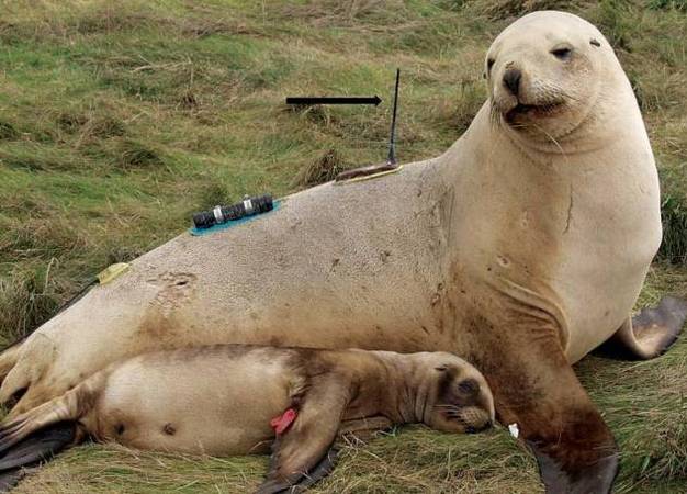
Figure 1
Female sea lion with brand, and telemetry equipment (black arrow indicates satellite transmitter on shoulder; time-depth recorder on mid-back; VHF transmitter on hip) temporarily glued to the fur.
© 2013 Nature Education Photo modified from Mellor et al. (2004). All rights reserved. 
Pop-up archival transmitters (PAT) tags
PAT tags accurately record and store information about water depth, temperature, and ambient light levels. Frequently used for monitoring large-scale movements, they have pre-programmed detachment dates, usually between 30 and 90 days. Upon floating to the surface, they transmit a data summary to passing ARGOS satellites. The raw data can be obtained upon retrieval of the tag (Hart et al. 2010, Hammerschlag et al. 2011).
Satellite-linked transmitters (SAT) tags
SAT tags accurately determine geographical locations via Doppler-shift calculations and transmission to orbiting ARGOS satellites. They are designed to be long-lasting, transmitting signals until they run out of batteries, or become detached. In sharks, they are frequently used in conjunction with SPOT tags (Hammerschlag et al. 2011).
Smart positioning or temperature-transmitting tags (SPOT) tags
SPOT tags are highly accurate devices for recording small-scale movements. They track movements at near-real time, and are particularly useful for tracking horizontal movements of individuals, which can be analyzed at much higher resolution than those obtained from PAT tags. SPOT tags contain a saltwater switch, which initiates transmissions only when it surfaces. The collection of geological positioning data is dependent on passing satellites, which may require the tagged animal to surface for long periods of time, w one of the major disadvantages of using SPOT tags (Hays et al. 2007, Hammerschlag et al. 2011).
New and Improved
Satellite and data logging technology is continually improving. Below is a brief summary of some of the most promising recent developments.
Fast GPS tags provide highly accurate positional tracking using global positioning systems (GPS), and are capable of recording individual animal interactions in air-breathing animals. Marine vertebrates must surface to transmit data (Holland et al. 2009).
Tri-axial accelerometer tags record detailed three-dimensional movements of tagged animals. This generates a thorough picture of behavioural activities such as mating, breathing, and feeding (Shepard et al. 2010).
Mobile phone telemetry sends recorded and stored data from tagged animals to the researcher via text message (Cronin et al. 2010).
Acoustic "business card" tags can be applied to free-ranging individuals, which can then emit and receive signals from other tagged animals, permitting mobile peer-to-peer (MP2P) transmission of data. The time, frequency, duration, and location of the exchange is recorded and transmitted via satellites. Valuable data about interactions with conspecifics, distances travelled, timing of mating or spawning rituals, and predator-prey relationships can be collected (Holland et al. 2009).
Satellite-Relayed Data Loggers (SRDLs) are tags that record an individual's location, speed, dive depth, and temperature of surrounding water. The data are then relayed via global ARGOS satellite systems (Fossette et al. 2008), bypassing the need to recover archival tags.
Why Tag Animals?
Studying demographics, ecology, migratory behaviour, and the potential overlap with anthropogenic activities can improve the way ecologists manage and conserve free-ranging marine vertebrates (Bograd et al. 2010). Understanding an animal's response to the environment can help determine the impact that ecological or climatic changes may have on a species, which can facilitate proper conservation strategies (Wilson 2011). Other motives for satellite tagging animals include accurate estimation of population sizes, survival rates, and reproduction within specific populations; ranges and distributions of individuals, populations, or species; growth rates; and individual foraging behaviours (Mellor et al. 2004, Maxwell et al. 2012). Individual animals are naturally hard to identify in the wild without some form of artificial marking or tagging. In marine environments, this is compounded by large home ranges, deep diving, and the visually obscure nature of aquatic habitats (Hammerschlag et al. 2011). Markers and tags come in many different forms, sizes, and shapes (Hart et al. 2010) (Table 1). The tag chosen depends on the species of interest and the nature of the study. Recently, satellite tags and data loggers have become so sophisticated and reliable that the information collected on marine vertebrates can be applied to map ocean profiles and provide oceanographic data (Fedak 2004). This offers researchers a cheap and ecologically friendly way to collect quality data across large-scale areas (Bograd et al. 2010, Hart et al. 2010).
| Temporary | Semi-permanent | Permanent |
|
|
|
| Table 1. Identification methods for marine mammals. Modified from Mellor et al. (2004). | ||
What is involved in tagging?
Almost every method of satellite and data logging telemetry requires capturing the animal, which can be stressful to both the animal and the researcher. Many tagging or marking procedures are fairly invasive and typically cause some degree of tissue damage. If carried out improperly, tagging may cause acute or even chronic pain, as well as risk infection (Mellor et al. 2004). Other problems can include alterations of appearances, social interactions, predator-prey relationships, movement, feeding, breeding, and migration patterns (Mellor et al. 2004). The most invasive of all tagging is surgical implantation. These techniques are becoming an increasingly popular method to study spatial ecology of free-ranging marine vertebrates. The surgical technique that is most often used in long-term data logging experimentation is intra-coelomic implantation. Although this method provides excellent data, surgical procedures increase the probability of negatively affecting the health and well-being of the animal and can lead to an early mortality (Cooke et al. 2011).
Effect on Animals
Tagging animals, if done improperly, can have detrimental effects, such as restricting foraging and breeding abilities, hindering movements, and lowering survival rates and fecundity (Wilson 2011). These effects may be immediately evident, or they may appear well after the marking has occurred. This may not only affect the individual's well-being, but could also upset the ecological balance, which is precisely what conservational biologists are trying to prevent (Fossette et al. 2008). Improper application of markers may also skew data obtained during the experiment, undermining the goals of the research (Mellor et al. 2004). Therefore, tagging procedures must be planned carefully in order to minimize the disadvantages to which an animal may be inadvertently subject, while maximizing collection of quality data (Bograd et al. 2010).
Tagging can Aid Conservation Efforts
In the past documenting movement and behaviours of large marine predators has been challenging at best. Fortunately, advances in satellite-tagging technologies have improved the way scientists track movements and habitat use of these streamlined animals (Figure 2) (Hart et al. 2010). Not only can these technologically advanced tags monitor movements, but they can also record many physical properties of the animal's environment, including water depth, ambient temperature, and water salinity (Hammerschlag et al. 2011). Shark conservation is a growing concern because of the relatively recent decline in shark populations, which is largely caused by increased numbers of fisheries and overexploitation. Through satellite tagging, scientists have been able to uncover migration patterns, temperature preferences, diving depth, and behaviours of many species, but despite this wealth of information, policy makers have yet to place regulations on shark harvesting. Stabilization of shark populations is dependent on continued research about their population diversity using satellite-tracking devices (Sherill-Mix & James 2008, Bograd et al. 2010). Another example of how tracking work has guided conservation efforts is a study of olive ridley sea turtles (Lepidochelys olivacea) in Central Africa. Maxwell and colleagues (2011) used satellite tracking to determine movements of 18 individuals during two breeding seasons and found that less than half of the areas that were most used by the turtles were inside current park boundaries, but that a proposed transboundary park between Gabon and the Republic of Congo would cover 98% of the sites used by the turtles. The study therefore provided strong scientific support for the proposed conservation park.
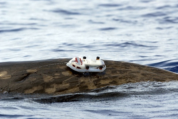
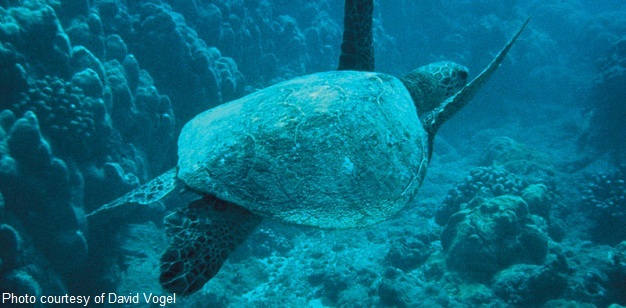
Figure 2
Male dense-beaked whale (Mesoplodon densirostris) with a satellite tag.
Photo courtesy of the U.S. Navy.
Public Support
Obtaining public support is extremely important for wildlife research and conservation efforts, especially if it is government-funded. Maintaining public interest in methods of wildlife research is critical for its success. It is important to keep the public informed on the benefits and risks associated with each method being used, correcting misinformation about the welfare of tagged animals whenever possible (Wilson 2011). Many methods appearing to adversely affect an animal's well-being (branding, or fin clipping), actually do not cause harm, and may very well be the most appropriate method for collecting valuable data. Public interest is critical for enabling wildlife research to continue; an informed community will respond most positively to animal tagging (Mellor et al. 2004).
Case Study: Tagging Leatherback Turtles
In the last 20 years, the majority of knowledge of leatherback sea turtle (Dermochelys coriacea) movement and behaviour has been collected from aerial surveys, fisheries, and direct observation. After compiling data from these sources, researchers were able to gather enough information to attribute a large majority of leatherback mortality rates to their incidental capture, or bycatch, by pelagic fisheries using longline hooks (Hays et al. 2004, James et al. 2005). As satellite telemetry and data logger technology advance, more information has become available regarding turtle behaviour during migration, including diving depth, foraging activity, and surfacing. Leatherbacks were found to be pelagic feeders, able to dive an average depth of 200 m during the foraging phase of migration, and even deeper (1200 m maximum) during the breeding phase (Fossette et al. 2008). Using long-term satellite telemetry, researchers had also observed a pan-oceanic migration route, and were able to highlight that at least 11 nations should be involved in efforts to conserve this species, in addition to those nations that run distant fishing fleets (Witt et al. 2011). These findings have significant implications for potential leatherback turtle interactions with fisheries. Firstly, at any given time, they are distributed randomly throughout the Atlantic, so prohibiting longline fishing from a specific region would have little effect on the population as a whole, and, secondly, their average dive depth is analogous to longline fishing hook depths, giving them a double disadvantage. To reduce bycatch, it is crucial that new methodologies in fishery procedures be applied, at least until more accurate migration patterns can be identified using advanced biotelemetry to pinpoint areas of high risk (Hays et al. 2004, James et al. 2005).
According to the 2011 version of the IUCN Red List, leatherbacks (IUCN# - A1abd) are a critically endangered species, so it is mandatory to use the least harmful procedures (Hays et al. 2004). Methods for attaching tags on most turtles cannot be used on leatherbacks, due to their soft leathery shell, or carapace. For the past two decades, satellite tags have been applied by attaching a custom-fitting, vinyl-covered nylon harness around the turtle's shoulders and midsection. These harnesses were integrated with corrodible links, which insured eventual deployment and retrieval of data when the tags reached the ocean surface (Sherrill-Mix & James 2008). Recently, however, problems that have resulted in negative impacts on the well-being of the turtles have been observed using this method, especially during long-term studies. A relatively new method used to study leatherbacks involves drilling three holes into the central dorsal ridge of the carapace and fixing a tracking device on an aluminum plate that is secured on the central portion of the shell using nylon ties (Hays et al. 2004, Fossette et al. 2008).
Fossette et al. (2008) tested these two techniques for variations in behaviour in the leatherback turtle. They fixed Satellite Relayed Data Loggers (SRDLs) on five turtles, three by harness and two by carapace drilling. After a three-month study, the results showed significant behavioral differences across several aspects of the turtle's life history. The harnessed turtles' travel rate was about 16% slower than the drilled turtles. The leatherbacks' migration route to the Northern Atlantic Ocean is about 4500 km long. A turtle travelling 16% slower would arrive over two weeks later than others, potentially inhibiting foraging and mating. Carapace-drilled turtles also performed longer dives at similar depths. These differences infer a hydrodynamic impact caused by the harness, as well as possible unbalanced buoyancy, both of which would negatively affect the turtle (Fossette et al. 2010). Movement was also slightly limited by the part of the harness that attaches over the shoulders, which was observed to rub against the front flippers, causing discomfort. Finally, the carapace-drilled turtles displayed much higher quality transmissions than harnessed turtles. This study concluded that satellite telemetry devices applied to leatherbacks should be fixed directly to the carapace (Fossette et al. 2008, Sherrill-Mix & James 2008).
In one report a leatherback turtle coming on shore to breed after a two-year migration still retained its harness. In order to ensure the recapture of the turtle, the researchers had replaced the corrodible links with non-corrodible ones. After physical examination of the turtle, researchers reported that the central platform of the harness had been embedded, approximately 8 cm, into the central carapace ridge in two places and the stainless steel rings used to attach the waist strap were encrusted into her skin. Although harnessing has been a reasonably successful method of studying migration of soft-shelled turtles for the last two decades, it can affect both the animal and the data collected (Fossette et al. 2008).
Conclusion
Satellite and data logger telemetry will continue to yield data that can be used in the field of ecological conservation and management of marine vertebrates. The advent of new and improved satellite and data-logging tags will aid in the development of novel strategies to stabilize populations of endangered species. As a result, studies can be conducted over much longer time-frames and will produce higher quality data than currently available.
References and Recommended Reading
Bograd, S. J. et al. Biologging technologies: New tools for conservation. introduction. Endangered Species Research 10, 1-7 (2010).
Clark, P. E. et al. An advanced, low-cost, GPS-based animal tracking system. Rangeland Ecology & Management 59, 334-340 (2006).
Cooke, S. J. et al. Advancing the surgical implantation of electronic tags in fish: A gap analysis and research agenda based on a review of trends in intracoelomic tagging effects studies. Reviews in Fish Biology and Fisheries 21, 127-151 (2011).
Cronin, M. A. et al. Using mobile phone telemetry to investigate the haul-out behaviour of harbour seals phoca vitulina vitulina. Endangered Species Research 10, 255-267 (2010).
Fedak, M. Marine animals as platforms for oceanographic sampling: a "win/win" situation for biology and operational oceanography. Memoirs of National Institute of Polar Research Special Issue 58, 133-147 (2004).
Fossette, S. et al. An alternative technique for the long-term satellite tracking of leatherback turtles. Endangered Species Research 4, 33-41 (2008).
Fossette, S. et al. Behaviour and buoyancy regulation in the deepest-diving reptile: The leatherback turtle. Journal of Experimental Biology 213, 4074-4083 (2010).
Godley, B. J. Tracking vertebrates for conservation: Introduction. Endangered Species Research 4, 1-2 (2008).
Hammerschlag, N. et al. A review of shark satellite tagging studies. Journal of Experimental Marine Biology and Ecology 398, 1-8 (2011).
Hart, K. M. & Hyrenbach, K. D. Satellite telemetry of marine megavertebrates: The coming of age of an experimental science. Endangered Species Research 10, 9-20 (2010).
Hays, G. C. et al. Endangered species - pan-Atlantic leatherback turtle movements. Nature 429, 522-522 (2004).
Hays, G. C. et al. Why do argos satellite tags deployed on marine animals stop transmitting? Journal of Experimental Marine Biology and Ecology 349, 52-60 (2007).
Holland, K. N. et al. Inter-animal telemetry: Results from first deployment of acoustic 'business card' tags. Endangered Species Research 10, 287-293 (2009).
James, M. C. et al. Behaviour of leatherback sea turtles, dermochelys coriacea, during the migratory cycle. Proceedings of the Royal Society B-Biological Sciences 272, 1547-1555 (2005).
Maxwell, S. M. et al. Benthic foraging on seamounts: A specialized foraging behavior in a deep-diving pinniped. Marine Mammal Science 28, E333-E344 (2012).
Maxwell, S. M., Breed, G. A. et al. Using satellite tracking to optimize protection of long-lived marine species: Olive ridley sea turtle conservation in Central Africa. PLoS ONE 6 (5), e19905 (2011).
Mellor, D. et al. Marking amphibians, reptiles and marine mammals: animal welfare, practicalities and public perceptions in New Zealand. Wellington, NZ: Dept. of Conservation (2004).
Shepard, E. L. C. et al. Identification of animal movement patterns using tri-axial accelerometry. Endangered Species Research 10, 47-60 (2010).
Sherrill-Mix, S. A. & James, M. C. Evaluating potential tagging effects on leatherback sea turtles. Endangered Species Research 4, 187-193 (2008).
Wilson, R. P. Animal behavior: The price tag. Nature 469, 164-165 (2011).
Witt, M. J. et al. Tracking leatherback turtles from the world's largest rookery: assessing threats across the South Atlantic. Proceedings of the Royal Society, B 278, 2388-2347 (2011).