
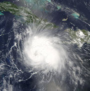
 Hurricane Charley gained in ferocity mere hours before lashing Florida's coast.© NOAA
For days the storm heading for Florida's coastline seemed like nothing out of the ordinary. It was menacing, but no more worrying than many other hurricanes that blow on to the eastern coast of the United States each summer. And yet, in the space of a few hours around Friday lunchtime, Hurricane Charley turned killer.
Charley began life as a 'category two' hurricane, bringing winds of 160 kilometres per hour swirling up through the Gulf of Mexico and towards Tampa Bay. But on 13 August, as it made a last feint to the east before setting its sights on Charlotte Bay, it roared up to a fearsome 260 kilometres per hour.
The resulting devastation, which claimed at least 16 lives and left tens of thousands seeking emergency shelter, is a brutal reminder of the difficulties faced by weather forecasters tracking storms.
Although forecasters are increasingly adept at predicting the path of a hurricane, they can still be taken by surprise when it comes to guessing its strength. "It's one of those things that is very difficult to predict," says Julian Heming of Britain's Met Office in Exeter. "Small variables can have a huge effect."
Hot streak
US weather experts suspect that Charley turned nasty when it hit a patch of warmer water in the Gulf. The increased evaporation would have reduced the already low atmospheric pressure in the storm system, drawing in more air and whipping the winds up yet further.
Added to this was the fact that the hurricane did not encounter the expected side-winds that might have slowed it down. But Heming says it is difficult to tease out the factors that made Charley so dangerous. "Anything at the moment would be speculative," he admits.
The problem with predicting intensity is that there are few measurements to go on, Heming says. Besides the fact that these devastating hurricanes are mercifully rare, it is also difficult to observe accurately what is going on inside them.
Charley was tracked by 'hurricane-hunter' aircraft equipped with wind, temperature and pressure gauges. These planes have a dual function: they help forecasters by observing the storm in real time and gain valuable readings with which researchers can construct models of hurricane behaviour.
But it is a risky business, says Heming. To get right into the heart of the storm, the planes deploy 'dropsondes', packages of meteorological instruments dropped by parachute. "But it is difficult to get the instruments in the right place," he says.
Experts at the US National Hurricane Center (NHC) maintain that they did as good a job of predicting Charley's outcome as possible. Because the storm was travelling close to Florida's gulf coast, where any deviation from its expected path could have brought it ashore, the entire region was placed on hurricane alert.
Charley reached full strength a mere three hours before it hit Charlotte Bay. Forecasters at the hurricane centre had predicted that it would reach category three rather than four. "The NHC is responsible for forecasting 24 hours ahead," a spokesman for the centre told news@nature.com. "But sudden increases in intensity are one of our priority issues."
