Thank you for visiting nature.com. You are using a browser version with limited support for CSS. To obtain
the best experience, we recommend you use a more up to date browser (or turn off compatibility mode in
Internet Explorer). In the meantime, to ensure continued support, we are displaying the site without styles
and JavaScript.
An analysis of satellite images has pinpointed individual tree canopies over a large area of West Africa. The data suggest that it will soon be possible, with certain limitations, to map the location and size of every tree worldwide.
Niall P. Hanan is with the Jornada Basin Long-Term Ecological Research Program, Department of Plant and Environmental Sciences, New Mexico State University, Las Cruces, New Mexico 88003, USA.
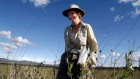
Terrestrial ecosystems are defined in large part by their woody plants. Grasslands, shrublands, savannahs, woodlands and forests represent a series of gradations in tree and shrub density, from ecosystems with low-density, low-stature woody plants to those with taller trees and overlapping canopies. Accurate information on the woody-vegetation structure of ecosystems is, therefore, fundamental to our understanding of global-scale ecology, biogeography and the biogeochemical cycles of carbon, water and other nutrients. Writing in Nature, Brandt et al.1 report their analysis of a massive database of high-resolution satellite images covering more than 1.3 million square kilometres of the western Sahara and Sahel regions of West Africa. The authors mapped the location and size of more than 1.8 billion individual tree canopies; never before have trees been mapped at this level of detail across such a large area.
National Academies of Sciences, Engineering, and Medicine. Thriving on Our Changing Planet: A Decadal Strategy for Earth Observation from Space (Natl Academies Press, 2018).

 Read the paper: An unexpectedly large count of trees in the West African Sahara and Sahel
 Satellite images show China going green
 An inventory of plants for the land of the unexpected