


« Prev Next »
Loess is a widespread, wind-transported, silt-dominated geologic deposit that covers about 10 percent of the Earth's land surface. Millions of people live in homes, work at businesses and use roads, railroads, and airports built on loess. Loess is also the parent material of the world's most productive agricultural soils. Because loess is deposited from the atmosphere it provides an important geologic archive of past atmospheric circulation that can be used to test atmospheric circulation models (Mahowald et al. 2006). Airborne dust, of which silt-size particles are an important component, also affects climate through its role in radiative transfer processes and by transporting mineral nutrients to the oceans, which affects primary productivity and the carbon cycle (Ridgwell 2002, Jickells et al. 2005). Loess deposits form where dust accumulates fast enough to form a distinctive silt-rich layer that buries soils or other geologic materials. A variety of geologic, climatic and biotic factors interact to form silt-size particles, mobilize and transport the silt from a source, and allow it to accumulate on the landscape.
Formation of Silt Particles
Silt particles are between 2–50µm (0.002–0.05mm) in size, intermediate between microscopic clay-size particles (<0.002mm) and sand (0.05–2mm) (Figure 1). Glacial grinding is very effective at producing silt-size particles, which are incorporated in till, reworked by meltwater and discharged into glacier-fed streams as "glacial flour" and deposited on outwash plains before being entrained and deposited by wind. Loess deposition is on-going in parts of Alaska, New Zealand, Iceland, and other areas where rivers carry silt-rich meltwater from today's glaciers. The geographic proximity of many of the world's great loess deposits to margins of former continental ice sheets and the rivers that drained them, as well as the coincidence of the age of the loess deposits with the advance and retreat of the ice sheets during the last ice age, reinforce the linkage of glacial grinding with silt production and loess formation.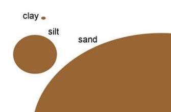
Figure 1: The relative sizes of sand, silt and clay particles.
Think of sand as the size of a basketball, silt a ping pong ball, and clay a grain of table salt.
© 2012 Nature Education All rights reserved. 
A number of other silt-producing mechanisms, such as frost shattering, comminution during transport in streams and on slopes, eolian abrasion and salt weathering, have been proposed to account for loess deposits that occur near arid or semi-arid regions where glaciers have not existed (Derbyshire et al. 1998, Wright et al. 1998, Wright, 2001, Whalley et al. 1982). However, recent studies have suggested that most of the silt making up the loess deposits associated with these "desert" sources probably formed in more distant glacial environments or was eroded from silty bedrock outcropping in the arid regions (Muhs & Bettis 2003).
Mobilization, Transport and Deposition of Silt by Wind
Deflation, the lifting and removal of particles from a surface by the wind, can occur if three conditions are met: 1) a source of dry sediment is available, 2) the wind is strong enough to mobilize the particles, and 3) the ground surface is not shielded from the wind by vegetation or other obstacles. These conditions are controlled by interactions among geologic materials, atmospheric phenomena, and biota, including human actions such as land clearing. Silt-size particles are especially susceptible to wind deflation-they lack the electrostatic charge and affinity for water that make clay-size particles stick to the surface, have less mass, and are therefore easier to suspend in wind than sand particles.
There are many potential sources for wind-transported silt since silt-size particles are ubiquitous in terrestrial environments. Silt particles are readily available along streams that drain glaciers and in dry intermountain basins where silt formed in distant alpine glacial environments and transported by streams into these basins is exposed when lakes and ponds dry up (Kapp et al. 2011). Outcrops of silty bedrock can also serve as sources for wind-blown silt, provided the constituent silt grains can be mobilized (Muhs et al. 2008). With the advent of large-scale land clearing and seasonal cultivation, agricultural landscapes have also become important sources of silt (Tegan et al. 1996).
Wind is the driving force behind eolian (wind-related) processes. The entrainment of silt and clay requires a stronger wind than is required to begin the movement of sand (the fluid threshold in Figure 2). In fact, energy from the impact of saltating sand grains that move at lower wind velocities greatly enhances the entrainment of silt and clay. Saltating sand grains impact the surface and eject silt and clay particles that would otherwise be difficult to entrain because of their cohesive nature and low profile to the wind. Once ejected, silt and clay particles are carried into the atmosphere by turbulent eddies where they move downwind in suspension, sometimes for prolonged periods of time. Silt and clay particles remain suspended in the atmosphere until 1) the wind velocity drops below the settling velocity of the particles, 2) electrostatic bonding of the particles produces aggregates with sufficient settling velocity to fall, or 3) dust particles or aggregates become incorporated in rain or snowfall (Pye 1995).
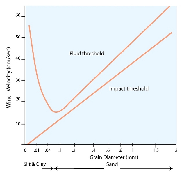
Figure 2: The relationship between particle size and wind velocity.
The fluid threshold velocity is the minimum wind speed necessary to initiate grain movement by the force of wind alone. The impact threshold is the minimum wind speed needed to initiate particle movement as a result of grain impact.
© 2012 Nature Education All rights reserved.
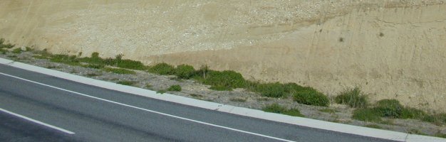
Several factors influence how strong the wind blows across the surface of the land and thereby how much silt (if any) will be mobilized. Particles or debris that is too large for the wind to move form an immobile "armor" that shields underlying grains from the wind and prevents them from being entrained. Plants, fences, and buildings that rise above the ground surface, as well as steeply sloping breaks in the landscape, affect the velocity and turbulence of the wind. These so called "roughness elements" control the height above the ground surface at which the wind's horizontal velocity is too low to mobilize particles (the "roughness height"). Vegetation cover thus suppresses sand movement and silt entrainment by keeping the roughness height above the ground surface and by armoring the surface with plant litter (Figure 3). As vegetation cover increases, less bare surface is available for silt entrainment. Vegetation and other roughness elements also promote deposition of wind-transported particles when the part of the vertical wind profile affected by them drops below the impact threshold. The degree to which vegetation or other roughness elements foster deposition is referred to as "trapping efficiency". Generally, tall and/or dense vegetation has a greater trapping efficiency than short or scattered vegetation. Topographic features, such as incised stream valleys, bedrock escarpments, or other impediments, can also trap saltating sand particles and thereby promote the accumulation of loess on their leeward side (Mason et al. 1999).
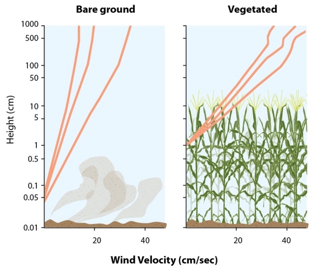
Figure 3: The effect of plant cover on the roughness height.
As plant height increases so does roughness height.
© 2012 Nature Education All rights reserved.
The Loess Depositional System
The production, entrainment, and deposition of loess involve interactions among the lithosphere, atmosphere, and biosphere that are ultimately controlled by climate. Cold conditions with sufficient moisture to support wet-based glaciers provide the "factories" for silt production as well as the outwash streams to transport sand, silt, and clay to locations where entrainment by the wind may occur. Sufficiently dry conditions must exist in the deflation area for sand to saltate and impact the surface so silt and clay particles can be ejected into the wind. Wind cannot entrain mineral particles from a moist surface because the force of the wind cannot exceed the surface tension of water between the particles. A bare surface with a moisture content of only a few percent is very difficult for wind to erode. Prolonged dry conditions will lead to less dense vegetation, more sand movement, and increases in the amount of silt and clay released to the atmosphere as long as sufficient sand, silt, and clay are available on the surface. On the other hand, topographic barriers or bioclimatic factors that reduce sand movement will decrease the amount of silt and clay entering the atmosphere in that location but increase the accumulation of silt and clay from upwind sources. As the loess depositional area expands, places experiencing saltating activity shift upwind. If bioclimatic conditions change to the point where saltation is no longer a major active process in the source area then significant dust generation and loess deposition cease.Because silt and clay particles are suspended in the atmosphere by turbulent eddies they can be transported far from their source area before accumulating as loess. The rate of dust deposition and thickness of the resulting loess deposit is greatest near the source and decreases with distance (Figure 4). Other properties of loess, such as average grain size, clay content, and mineralogical composition may also vary systematically with distance from the source (Figure 5, Muhs et al. 2008). These variations impart physical and chemical patterns on loess landscapes that affect soil erosion, slope stability, water-holding capacity, and other important properties.
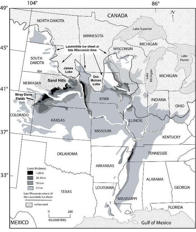
Figure 4: The distribution and thickness of loess, the distribution of large, contiguous dune fields, and the late glacial limit of the Laurentide Ice Sheet in the North American midcontinent.
Prevailing wind direction during loess deposition was from the northwest and west. Note the accumulations of thick loess south and east of the Missouri and Mississippi River valleys, which carried outwash from the glacial margin, and southeast of the Nebraska Sand Hills and the Wray Dune Fields, southwestern Nebraska, and northeastern Colorado.
© 2012 Nature Education Adapted from Muhs et al. 2008. All rights reserved.
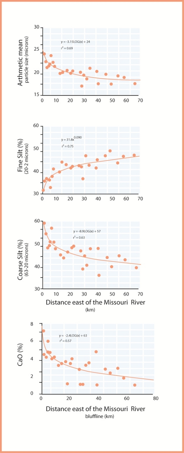
Figure 5: Trends in grain size and calcium oxide content of last glacial loess with distance from the Missouri River Valley source.
The average grain size of the loess and the content of coarse silt systematically decrease with distance from the valley source while the content of fine particles increases. Calcium oxide (a proxy for calcium carbonate) content is greatest near the source valley and decreases with distance away from the valley. The carbonate decrease is a product of less carbonate in the finer particle size fractions and more effective leaching of carbonate as the loess thins with distance from the valley.
© 2012 Nature Education All rights reserved.
Examples
Examples from modern Alaska and from the last glacial period in the American Midwest illustrate the workings of two loess depositional systems-one directly tied to glaciers and a second linked to dry conditions in a source area. Frequent high winds in the lower part of central Alaska's Delta River valley result in dust storms and deposition of modern loess. Several valley glaciers that provide silt-laden outwash exposed to strong winds that dry the braid plain during low flow periods feed the river. Sand saltating across the exposed and vegetation-free braid plain ejects silt and clay particles, which are swept into the air by turbulent eddies (Figure 6). Downwind vegetation traps some of the entrained silt and clay as dust coatings on leaves, stems, trunks, and the soil surface. Trapping is especially effective when the vegetation is moist with dew or frost. Loess that has been accumulating during the past several thousand years on both sides of the valley provides a longer-term perspective on the loess accumulation process. The loess thins from several meters in thickness on bluffs in the conifer forest next to the river to less than a meter in a similar forest several kilometers downwind. At nearby tree line localities the loess is significantly thinner because the vegetation is lower and more open with a much lower trapping efficiency than in the conifer forest.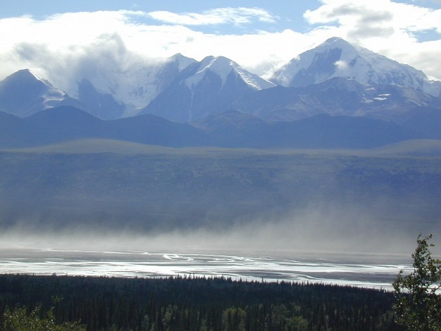
Figure 6: Dust (primarily silt particles) is entrained from the dry braid plain of the Delta River in Central Alaska.
Some of the dust is trapped by coniferous forest vegetation near the river to form thick loess deposits.
© 2012 Nature Education All rights reserved.
A large area of thick last-glacial loess abruptly borders the southeastern margin of the Nebraska Sand Hills, which was the largest active dune field in North America during the last glacial period, and as recently as 1500 years ago (Figure 4). Compositional studies of the loess indicate that siltstone outcrops northwest of the Sand Hills were the source for the loess (Muhs et al. 2008). One model proposed to explain these loess thickness and composition relationships is that cold, dry last-glacial climatic conditions in the Upper Midwest fostered sparse vegetation cover and freeze-thaw cycles that resulted in ideal conditions for sand movement and wind erosion of the exposed siltstone. Silt and clay particles entrained in the source area were blown to the southeast into the active Sand Hills dune field where saltating sand re-entrained any settling silt and clay. Silt and clay continued to move over and through the Sand Hills until saltating sand dropped out of the system at river valleys and other topographic barriers along the southeastern margin of the dune field (Mason 2001). With the impact of saltating sand no longer acting to re-suspend silt and clay and with continued entrainment and transport of silt from upwind, thick loess accumulated on the landscape southeast of the Sand Hills (Figure 7).
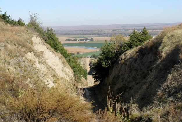
Figure 7: A thick loess deposit dating from the last glacial period in central Nebraska, U.S.A.
The wind-blown silt particles that form this deposit were eroded from silty bedrock and transported through the Sand Hills dune field (in the distant background) before encountering the Platter River valley, a topographic break that stopped saltating sand and caused the loess to accumulate.
© 2012 Nature Education Photo courtesy of Dan Muhs, U.S. Geological Survey. All rights reserved.
Summary
Loess sedimentary systems are driven by climatic and landscape processes and conditions that produce silt particles, entrain and transport the particles from source areas, and foster sufficient silt accumulation downwind of the entrainment area to form a loess deposit. Dry source areas with a sparse vegetation cover allow for sand saltation and ballistic entrainment of silt particles, processes that enhance silt deflation and transport. Conversely, surfaces where loess accumulates generally lack saltating sand and must have shelter from the wind, which may be provided by vegetation, topographic barriers, or other conditions that reduce wind velocity.References and Recommended Reading
Derbyshire, E. et al. Provenance, transport and characteristics of modern aeolian dust in western Gansu Province, China, and interpretation of the Quaternary loess record. Journal of Arid Environments 39, 497-516 (1998).
Jickells, T. D. et al. Global iron connections between desert dust, ocean biogeochemistry, and climate. Science 308, 67-71 (2005).
Kapp, P. et al. Wind erosion in the Qaidam basin, central Asia: Implications for tectonics, paleoclimate, and the source of the Loess Plateau. GSA Today 21, 4-10 (2011).
Mahowald, N. et al. Climate response and radiative forcing from mineral aerosols during the last glacial maximum, pre-industrial, current and doubled-carbon dioxide climates. Geophysical Research Letters 33, L20705 (2006). doi:10.1029/2006GL026126
Mason, J. A. Transport direction of Peoria Loess in Nebraska and implications for loess sources on the central Great Plains. Quaternary Research 56, 79-86 (2001).
Mason, J. A. et al. A new model of topographic effects on the distribution of loess. Geomorphology 28, 223-236 (1999).
Muhs, D. R. & Bettis, E. A. III. "Quaternary loess-paleosol sequences as examples of climate-driven sedimentary extremes," Extreme Depositional Environments: Mega End Members in Geologic Time, Special Paper 370, eds. M. A. Chan & A. W. Archer. Boulder, CO: Geological Society of America, 53-74 (2003).
Muhs, D. R. & Bettis, E. A. III. "Quaternary loess-paleosol sequences as examples of climate-driven sedimentary extremes," Extreme Depositional Environments: Mega End Members in Geologic Time, Special Paper 370, 53-74. eds. M. A. Chan & A. W. Archer. Boulder, CO: Geological Society of America, 2003.
Ridgwell, A. J. Dust in the Earth system: The biogeochemical linking of land, air and sea. Philosophical Transactions of the Royal Society A: Mathematical, Physical and Engineering Sciences 360, 2905-2923 (2002).
Tegan, I., Lacis, A. A. & Fung, I. The influence on climate forcing of mineral aerosol from disturbed soils. Nature 380, 419-422 (1996).
Whalley, W. B., Marshall, J. R. & Smith, B. J. Origin of desert dust from some experimental observations. Nature 300, 433-435 (1982).
Wright, J. S. "Desert" loess versus "glacial" loess: Quartz silt formation, source areas and sediment pathways in the formation of loess deposits. Geomorphology 36, 231-256 (2001).
Wright, J. S., Smith, B. J. & Whalley, W. B. Mechanisms of loess-sized quartz silt production and their relative effectiveness: Laboratory simulations. Geomorphology 23, 15-34 (1998).