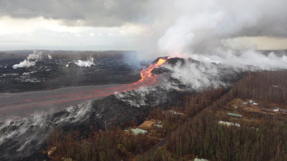
Thank you for visiting nature.com. You are using a browser version with limited support for CSS. To obtain
the best experience, we recommend you use a more up to date browser (or turn off compatibility mode in
Internet Explorer). In the meantime, to ensure continued support, we are displaying the site without styles
and JavaScript.
When nature strikes with force, the effects can be devastating. It is critically important to better study and understand natural hazards to help mitigate against their effects. In this collection, we focus on geological hazards such as volcanic eruptions, tectonic earthquakes and mass movements.
Equitable partnerships among the international volcano science community are important now more than ever, to cope with financial disparities and ultimately allow for worldwide volcano monitoring oriented to hazard mitigation.
Interacting geological processes can cause complex hazard cascades that threaten life and property. Past events are instructive, but physical understanding must be paired with effective communication to minimize the risks posed by these events.
The 2011 Mw 9.1 earthquake and tsunami caused incomprehensible damage along the northeast coast of Japan. This Snapshot discusses the measures that have been put in place over the past 10 years to mitigate hazards of a future tsunami disaster.
The unprecedented cost of the 2018 eruption in Hawai’i reflects an intersection of disparate physical and social phenomena: widely spaced, highly destructive eruptions, and atypically high population growth. These were linked and the former indirectly drove the latter with unavoidable consequences.
Large-scale radiant heat flux increased in the years prior to eruptions at five volcanoes, probably due to enhanced underground hydrothermal activity, according to an analysis of satellite infrared data.
This review dives deep into how earthquakes affect volcanoes, specifically into the relation between tectonic seismic activity and subsequent eruptions. Activity may increase in any volcanic setting in the 2–5 years following an earthquake, and especially at volcanic centres featuring vigorous hydrothermal activity.
Pyroclastic density currents are complex multiphase flows originating from volcanic eruptions and account for almost a third of volcanic fatalities globally. This Review discusses recent advances in understanding of the complex internal processes within pyroclastic density currents and how these influence the flow dynamics and hazard footprints.
Pyroclastic density currents are able to travel large distances because they generate their own air lubrication, according to large-scale laboratory experiments.
Forty years after the Mount St Helens eruption galvanized volcano researchers, they are using powerful new tools to spy on the world’s most dangerous mountains.
The authors here present geodetic and seismic data for a complete eruptive cycle (2005-2018) for Sierra Negra volcano, Galapagos Island. The data shows the largest pre-eruptive inflation (6.5 m) and rates of seismicity ever observed before a basaltic eruption and provides a rare illustration of caldera resurgence mechanisms.
In this study, the authors investigate the predictability of sudden eruptions, motivated by the 2019 eruption at Whakaari (White Island), New Zealand. The paper proposes a machine learning approach that is able to identify eruption precursors in data streaming from a single seismic station at Whakaari.
In a Hawaiian fountain eruption, rapid gas expansion cools the melt below the glass transition temperature and causes brittle magma fragmentation, producing small, vesicular pyroclasts, according to observations of the 2018 eruption of Kīlauea.
In explosive basaltic eruptions, brittle fragmentation and subsequent healing by viscous melt are documented by textural analysis of products from ten disparate eruptions, suggesting that grain size may not reflect the initial fracture density of magma.
Here, the authors use 20 years of ground deformation data from Stromboli and correlate this data with eruptive records. They find that duration and amplitude of the inflation trend scales with eruption magnitude, indicating that explosive dynamics obeys the same (scale-invariant) conduit process.
To reduce the risks and uncertainty that surround volcanic eruptions, attention must be given to all available data. Historical records can provide insight into past eruptions, as well as the social and political responses to volcanic activity.
Immediately before and during the eruption of Kīlauea Volcano in May 2018, anomalously high rainfall increased the pore pressure in the subsurface to its highest level in 50 years, causing weakening and mechanical failure of the edifice.
The processes leading to large earthquakes remain enigmatic. Using detailed seismic and geodetic data, this Review examines how tectonic deformation and evolving fault behaviour initiate large earthquakes, and proposes an integrated model accounting for the diversity of observations.
Risk communication in the aftermath of an earthquake can provide actionable information to help vulnerable societies prevent further damage. It is most effective when scientists convey what they know about earthquakes and earthquake risk, instead of focusing on the unknowns.
Low-angle normal faults in the Banda Sea have caused large earthquakes that indirectly generated tsunamis due to earthquake-triggered submarine slumping, according to an analysis of historical earthquake and tsunami events and GPS observations.
The authors here present a deep learning method to determine the source focal mechanism of earthquakes in realtime. They trained their network with approximately 800k synthetic samples and managed to successfully estimate the focal mechanism of four 2019 Ridgecrest earthquakes with magnitudes larger than Mw 5.4.
The authors here present a deep learning model that simultaneously detects earthquake signals and measures seismic-phase arrival times. The model performs particularly well for cases with high background noise and the challenging task of picking the S wave arrival.
Inelastic failure in the 2019 Ridgecrest earthquakes was localized and influenced by mylonitic deformation of the fault damage zone, according to an analysis of surface displacements derived from satellite images.
The 2019 Le Teil earthquake in southern France reactivated an existing fault and ruptured the surface, according to field, seismic and InSAR observations. The incredibly shallow hypocenter can explain the effects of the moderate Mw 4.9 event.
The authors show that seismogenic faults can be activated by stress perturbations by all possible modes of slip independently of the frictional properties. They demonstrate, that the nature of seismicity is mostly governed by the initial stress level along the faults.
In this study, the authors propose that a fluid rich environment is necessary to generate long-lasting aftershock sequences. Based on this premise, the study presents a theory for modeling fluid-driven earthquake sequences
Changes in the average size distribution of earthquakes are used to discriminate between foreshocks and aftershocks, and a traffic light classification is proposed for the real-time assessment of the probability of a subsequent larger event.
Some landslides creep at low velocities of a few millimetres to metres per year, forced by external factors such as rainfall, snowmelt, earthquakes or anthropogenic forcings. This Review discusses the recent advances in understanding slow-moving landslides and examines circumstances where slow-moving landslides can accelerate and fail catastrophically.
Aqueduct-supported cultivation of rice resulted in liquefaction of the alluvial soils that led to the landslides triggered by the Palu 2018 earthquake, according to satellite analyses.
This study investigates the relation between El Nino and landslide impacts. The authors show how El Nino and La Nina can cause swings in exposure of population to landslides that are as large as those due to rainy-season/dry-season variability in key locations, particularly South America.
A delayed increase of landslide activity occurred about two to six years after two volcanic eruptions in Chile in 2008 and 2011, according to remote-sensing data. The time lag is consistent with decaying tree roots in areas covered by tephra.
On 22 December 2018, the western flank of Anak Krakatau collapsed into the sea of the Sunda Strait triggering a tsunami which killed approximately 430 people and displaced 33,000. Here, the authors show that Anak Krakatau exhibited an elevated state of activity several months prior to the collapse, including precursory thermal anomalies, an increase in the island’s surface area, and a gradual seaward motion of the southwestern flank.
An unsolved fatal accident of 9 Russian mountaineers in the northern Urals in 1959 can be explained by a slab avalanche released due to a slope cut to install the tent and wind-blown snow accumulation affected by an irregular topography, according to analytical and numerical models.
The authors describe a huge submarine landslide deposit offshore Tanzania and highlight that large and potentially tsunamigenic landslide events are associated with plateau uplift and continental rifting in East Africa.
Landslides triggered during the Palu 2018 earthquake correlate spatially with the presence of irrigation systems according to satellite analyses, suggesting that liquefaction of alluvial fans played a role.
The authors here present a multi-lake paleoseismological approach to evaluate the role of earthquakes in causing a spatio-temporal cluster of large, prehistoric rockslides between 3000 and 4200 years ago in the Eastern European Alps and for which the triggering mechanisms are still debated.
The authors here present a detailed reconstruction of the landslide mass following the 2018 eruption of Anak Krakatau. Bathymetry data reports the volume of the collapsed submarine flank to be much larger than previously reported.