A break in the levee holding back the Mokelumne River, California, resulted in the flooding of a farm built on the river's floodplain.Credit: Erica Gies
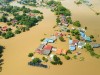
When water inundated parts of New York City in September 2023, 28 people had to be rescued from their cars and basement apartments. Thankfully, no one died this time. In 2021, flooding in New York killed 11 people. Neighbourhoods in the city also flooded in 2020 and 2022, and it’s not just New York. Floods are becoming increasingly frequent and severe globally, as are droughts. Steve Bowen, chief science officer for reinsurance firm Gallagher Re in London, described the most recent New York floods on X (formerly Twitter) as “the latest example of ageing infrastructure built for a climate that no longer exists”. Such sentiments are common, and frequently followed by calls for more infrastructure: bigger levees and seawalls, larger pipes and stormwater tanks, and more dams, aqueducts and desalination plants.
But human-built infrastructure and land-development practices that leave little space for water are actually a big part of the problem. Eric Sanderson, a conservation ecologist and author of Mannahatta: A Natural History of New York City (2009), called this out pithily in a series of posts on X. He captioned a video of water pouring into a subway stop: “Under former salt marsh” and one of a flooded area in Brooklyn, “Former bog”.
Engineered structures intended to control water, urban sprawl and industrial forestry and agriculture have drastically altered the natural water cycle, contributing to both increased flooding and water scarcity. Society has dammed and diverted two-thirds of the world’s large rivers, drained as much of 87% of global wetlands and degraded 75% of Earth’s land area. “We need to let nature play its original function,” says Adnan Rajib, an engineer and director of the H2I lab at the University of Texas at Arlington. “Water doesn’t have anywhere to go.”
Climate change is also a factor in today’s water extremes, scientists agree, but blunting the impact of floods and droughts will take more than reducing carbon emissions. Decision makers must also change how they manage land and water. “The climate crisis is real,” says Kris Johnson, a conservation biologist and director of agriculture for The Nature Conservancy, an environmental organization in Minneapolis, Minnesota. “But the biodiversity and water crises are also real and interdependent.” Engineered solutions to water problems — such as levees or dams — typically overlook the complex relationships between water, rocks, soil, plants, animals and atmosphere. Failing to account for that complexity often damages the natural systems that support life and the water cycle, contributing to increased flooding and water scarcity.

Most of the traditional eris tanks in Chennai, India, are now only associated with temples.Credit: Erica Gies
Around the world, scientists, farmers, urban planners, landscape architects, and water utilities and flood managers are taking heed and restoring wetlands, floodplains and forests that development has disrupted. Their efforts, which return space to water where it naturally slows or stalls on land, are unique to each place’s geology, ecology and culture. ‘Slow water’ projects work with natural systems rather than trying to control them and they are socially just. They are distributed across the landscape, not centralized, and make the most of local water.
Slow it down
Floodplains are one phase of slow water that are prone to human disruption. They hold and release water, redistribute sediment and generate food for aquatic life. But around the world, engineers and farmers have built levees along rivers, cutting them off from their floodplains. “Everyone is doing research on how floods impact humans,” says Rajib. However, he adds, “it’s also the humans that are causing the floods”.

Eris tanks were traditionally used to slow the flow of water from the mountains.Credit: Erica Gies
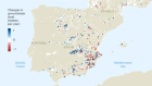
In a study published in July1, Rajib and his colleagues found that, from 1992 to 2019, humans have encroached on 600,000 square kilometres of floodplains — an area about the size of Ukraine. In taking space from water, such development causes rivers to rise and places people living nearby at higher risk of flooding.
Reducing that risk requires the engineered infrastructure installed by humans to be altered or undone. Hydrologist Nicholas Pinter at the University of California, Davis, studies how some communities reduce their risk. Along smaller rivers in the Sacramento Valley, California, non-governmental environmental organizations have returned floodplain space to rivers. Pinter says that during the numerous atmospheric river storms of winter 2022–23, “the only portion where the levees broke were where they didn’t set them back”.
Sprawling cities
Many cities around the world are built on floodplains, covered-over streams and filled-in wetlands. Urban areas have doubled since 1992, exacerbating flood risk — for every 1% increase in paved area, annual flood magnitude in nearby rivers increases by 3.3% from run-off. When cities flood, municipal leaders attempt to disperse the water as fast as possible, rather than retain it for dry seasons. Then when water is in short supply, they drill deeper wells to reach ground water, bring in distant water through aqueducts or desalinate seawater to meet the needs of the community.
In the wake of increasingly frequent and expensive disasters, some cities are changing tack and making places for water to soak into the ground again. These include stormwater ditches lined with native plants, permeable pavement, green roofs, planted medians, tree wells, and parks on reclaimed industrial areas in river floodplains. These strategies go by different names: low-impact design in the United States, for example, and sponge cities in China — where creating them is a national policy.
Chennai, India, is one place that is returning space to water. Nearly every summer, the city runs out of water. The painful irony, however, is that the annual monsoon brings 1.5 times the water that Chennai’s residents use each year. Flooding is also frequent, and starts soon after even moderate rains. The city’s area is now nine times larger than it was in 1980, hemming in three rivers, as well as covering over backwaters, coastal estuaries, mangrove forests and ancient human-built lakes. In 2015, a disastrous flood killed at least 470 people and pushed city managers to alter their course.
Today, Chennai deploys slow-water techniques across the city, including protecting remaining wetlands, restoring them where possible and reviving the region’s 2,000-year-old water infiltration system that was once used to provide water year-round. Made up of structures called eris, the system ran from the mountains down to the Bay of Bengal. Eris (Tamil for tanks) are open on the higher side to catch water flowing downhill and closed by an earthen wall on the lower side. A divet in the wall on the low side allows water to flow downhill to the next eri. By slowing the flow of water, the eris reduce flooding, prevent soil erosion and give water time to seep underground — where it is filtered and kept within reach of wells.
Despite being impressed by the estimated 53,000 or so eris across southern India, the British introduced centralized management in the nineteenth century, destroying the communal system by which local people maintained their eris and shared water resources. The eris that remain in cities are often connected with temples. Chennai is home to 54 temple eris, and water managers are restoring pathways for storm water to flow to them — and to link them with remaining and restored natural water bodies. The managers expect this to reduce both flooding and scarcity by absorbing and storing local rain.
The eris system is unique to southern India. But as Yu Kongjian, co-founder of landscape architecture firm Turenscape, Beijing, and proponent of sponge cities in China, says in the Chinese edition of Water Always Wins (2023), “Each nation has a ‘slow water’ cultural heritage.” Part of the solution in a given place is to include the strategies of earlier inhabitants to work with natural systems to manage water.
Forests and farms
Slow-water approaches can also reduce fire severity. Canadian wildfires burnt almost 19 million hectares during the summer of 2023, choking cities across North America. Climate change and misguided policies of stamping out all fires have played a large part in extreme blazes, but commercial forestry shares some of the blame because of how it alters the natural water cycle.

A levee was broken for the Cosumnes River near Sacramento, California, to allow water from the river access to part of the floodplain.Credit: Erica Gies
Tree roots create pathways for water to move underground, storing rainfall locally. The ground water that trees transpire into the air forms clouds and, along with evaporation from soil, becomes the source of 10–80% of rain over continents, depending on location2. Losing forests can, therefore, increase run-off and decrease rainfall.
Francina Dominguez, a hydroclimatologist at the University of Illinois Urbana–Champaign, has found another way that deforestation reduces rain. The surface roughness of mixed-species forests makes them better than tree plantations or crops at slowing wind, and thereby makes it more likely that vapour will condense into rain3.
Natural forests are much more efficient at regulating water and climate than are commercially logged forests. A mature native forest transpires more water than younger tree plantations, and it contains understorey plants, rich soil and decomposing wood that create a spongy, moist environment. Clear-cutting desiccates this system. Anastassia Makarieva, an atmospheric physicist at the Technical University of Munich in Germany, says that for greater water-cycle stability, remaining old growth should be conserved and some altered areas restored. This should start at the edge of wetter areas, she says, to cumulatively increase water-vapour density and restart the local rain cycle.
Replacing perennial vegetation, either forests or grasslands, with annual crops also reduces the amount of evaporation and transpiration, says Dominguez. Agriculture changes the water cycle in more obvious ways too, such as accounting for 70% of water use, and, in wetter places, such as the US Midwest, through draining of swamps by farmers to create crop land.
Other standard agricultural practices tend to work against a sustainable water cycle. The higher the percentage of organic matter in soil, the more water it can hold, and the better it can absorb flood water and retain the water until plants need it, reducing the need for irrigation. But ploughing dries out and compacts soil, and pesticide treatments kill animals that help to keep water and biochemical cycles healthy.
Returning some marginal cropland — land with degraded agricultural value — to wetland or grassland “could actually reduce the flood peak for the system overall”, says Johnson, who is a co-author on Rajib’s floodplain encroachment study. That wouldn’t have to mean a reduction in the quantity of food produced. Globally, people are pulling back from marginal farmland, leaving that land available for restoration. Some agricultural lands that flood routinely should be fallowed, says Johnson, rather than insured against flood damage. “We want to make sure that we’re not incentivizing behaviour that is likely to fail.” In places such as California and the Netherlands, some floodplains have been partially returned to rivers as relief valves for high flows. Farmers who grow on the land are compensated when they lose their crops.
In drought-prone areas, agricultural and urban expansion, and unsustainable groundwater pumping are exacerbating water scarcity, says Johnson. Shifting thirsty crops away from water-stressed places makes sense, he says. California, for example, has introduced a funded programme that could take as much as 400,000 hectares out of use by 2040, because agriculture in the area has expanded beyond what the available water can support.
A draining experience
Some water stress is caused by what biologist and hydrologist Brock Dolman calls the “age of drainage”. According to Dolman, who is co-founder of the non-profit organization Occidental Arts & Ecology Center in California, European settlers and their descendants dried out land by killing beavers that created wetlands across 10% of North America, overgrazing animals they brought with them, and overpumping ground water so that plant roots could no longer reach it. But various efforts are starting to turn that around, including supporting the recovery of beaver populations.

Compared with Rock Creek (left), which has no natural infrastructure, the slow-water approach at Turkey creek (right) extends water availability into the dry season.Credit: Laura Norman
Where beavers aren’t present, land managers are also attempting to slow water in degraded streams. When Valer Clark and Josiah Austin moved to their ranch south of Tucson, Arizona, in the 1980s, they found a land denuded of trees and grazed to the bone. Monsoon rains roared through stream channels, called washes, eroding them. The water then quickly disappeared. Clark and Austin hand-built small rock dams in the headwaters of the often-dry Turkey Creek, following local Indigenous methods. Within a few monsoon seasons, the structures caught sediment, held water and became a series of wetland sponges that seeped water year-round. Downstream landowners were worried that Clark and Austin were holding onto ‘their’ water.
But physical scientist Laura Norman at the US Geological Survey in Tucson found that this was not the case. Intrigued by the transformation, she compared Turkey Creek with neighbouring Rock Creek. She found that the rock dams slowed flash floods and extended water availability into the dry season. And most surprisingly, the structures actually increased the stream’s flow by 28%4. That’s because, in Rock Creek, some of the water flowing over the bare bedrock evaporates immediately, she explains. By contrast, the water-slowing approach taken at Turkey Creek allows the water to sink underground. The US Forest Service and the state of Arizona are now authorizing the building of these structures on their land.
A growing body of evidence is showing that floods and droughts are caused, in part, by people’s land-use choices. And researchers are documenting the multiple benefits of restoring slow-water systems in cities, forests, agricultural lands and grasslands. Bringing the natural water cycle back into balance, researchers say, will require a decentralized mindset, with a focus on developing thousands of small projects throughout water’s path. “When you look at one particular storage space for water in one particular location, maybe that is insignificant,” says Rajib. “But when you look at their connectivity across the basin, continent or the world, the cumulative impact is substantial.”
 Water: a source of life and strife
 The most important issue about water is not supply, but how it is used
 Fresh water from thin air
 How to take ‘forever’ out of forever chemicals
 Sizing up hydrogen’s hydrological footprint
 Water and warfare: the battle to control a precious resource
 Webcast: How water researchers are rethinking the global flood crisis