The first half of 2022 was one of the deadliest on record for landslides. In January and February, cities across South America were hit by devastating soil, rock and mud flows — burying at least 14 people in their homes at Dosquebradas in Colombia, and killing 24 people in Quito, Ecuador, and at least 220 in Petrópolis, Brazil. In April, May and June, hundreds more were killed in Pilar in the Philippines, Durban in South Africa, Recife in Brazil and across Bangladesh.
That’s fast approaching the roughly 4,500 people who are killed on average worldwide each year by landslides1. Economic damages from these events amount to US$20 billion annually2, which is roughly one-quarter of those resulting from floods.
Over the past 50 years, disasters caused by landslides have become ten times more frequent3. And landslide risk is set to escalate, owing to two increasing trends — climate change and urbanization. Now, researchers need to assess where and to what extent such risks will rise.
More than 80% of fatal landslides occur in the tropics1. They are triggered mainly by heavy rain, often during cyclones and monsoons. Climate projections show that, on average, the intensities of tropical deluges could double by the end of the century4. But it’s hard to say what will happen in any given place.
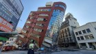
The rapid pace of urbanization, especially in low- and lower-middle-income nations in tropical regions, will put more people in the path of landslides. For example, the population of Freetown in Sierra Leone has nearly doubled, to more than 1.2 million, since 2000. Many people arriving in the city end up living in poor or informal settlements on hills and floodplains at the city margins. Informal housing practices such as unregulated deforesting, slope cutting and household water drainage, can increase the chance of landslides. And such communities are hit disproportionately hard. For example, in Latin America and the Caribbean, 81% of the people killed in landslides since 2004 lived in poor or informal settlements, even though those settlements saw just 41% of the fatal landslides recorded in those regions5.
Five ways to ensure flood-risk research helps the most vulnerable
Current landslide risk assessments fall short in a fast-changing environment. Predictions at city or broader scales are often based on historical data — more landslides are expected to occur in locations similar to those where they happened before. Yet records are often poor or missing in low- and middle-income nations, and environmental changes can reduce the usefulness of historical records for long-term projections. Causes and impacts, physical and social, are treated separately. And efforts to address risk are siloed. For example, engineers tend to focus on stabilizing slopes at specific sites, city planners on enforcing regulations to prevent construction in landslide-prone areas and social scientists on examining people’s perceptions of risk.
Instead, disaster risk reduction experts need to consider ‘dynamic’ interactions between the natural environment, rainfall patterns and informal urbanization. Researchers must also consider the root causes and drivers of risk that push the most vulnerable people into hazard-prone locations — including economic and political inequalities, loss of sustainable rural economies and population growth6.
Quantifying all these interactions is challenging but increasingly possible, thanks to advances in satellite imagery and remote sensing, data gathering and modelling. To illustrate, here we combine data and models of urban landslides and climate change to identify likely hotspots of landslide risk in five cities in the tropics. We call on policymakers and practitioners to use such evidence-driven assessments to inform disaster risk reduction policies.
Growing risks
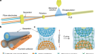
Landslides occur when gravity overcomes the resisting forces of soil or rock on an incline, causing a mass to slide, fall or flow downhill. Heavy rainfall is the main trigger — as water infiltrates the ground, it increases the pressure in pores, weakening the soil. In general, the steeper the hillslope and the weaker the material it’s made from, the more unstable it will be. Other factors, such as plant roots, might provide some reinforcement.
Human modifications to slopes can make them more likely to fail. Cutting into them, for terracing or to flatten the ground for houses or roads, makes them steeper and thus more unstable. Removing plant cover and adding water through poor drainage or leaking pipes also increases the risk of landslides. So does mining and the construction of roads and other infrastructure. All told, the annual death rate from landslides linked to human activities has risen fivefold since 20041. Such vulnerabilities are rife in informal settlements, where one billion people currently live.
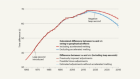
The link between urbanization and landslide risk is known, but poorly quantified. As a rule of thumb, landslides typically occur on hillsides steeper than 10°, and the likelihood rises as the angle of the slope increases. Cities such as Caracas in Venezuela and Taiz in Yemen each have more than 1.6 million people living on ground steeper than 15°. As more people inhabit the outskirts of cities, the number living on slopes of 10° or more is increasing (see ‘Urbanization trends’). Also increasing in number are those living on the flatlands below, which are at risk from debris flows.

Source: U. Ozturk et al.
In 2020, around 220 million people lived within 100 metres of slopes of 10° or higher, increasing their risk of being hit by a landslide flow. The 2017 Regent Landslide in Freetown is one tragic example: it triggered a surge of mud and rock that buried hundreds of homes and killed more than 1,000 people as it flowed for 6 kilometres along a creek.
Detailed analysis
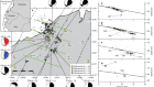
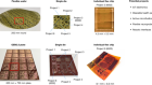
To quantify the degree to which informal communities face growing landslide risks, we analysed the slopes on which urban settlements sit in five representative cities across the tropics: Freetown, Antipolo and Baguio in the Philippines, Port-au-Prince in Haiti and Bukavu in the Democratic Republic of the Congo (DRC).
The ‘informality’ of settlements can be quantified using the degree of inaccessibility of buildings in OpenStreetMap7. This metric counts the number of building premises an individual would cross if walking from the least-accessible one in a block to the nearest external street. The more buildings, the more inaccessible the neighbourhood, and thus the more informal (see Supplementary information).
Using that score, we found that informal settlements in all five cities tend to be located on steeper slopes compared with more-planned neighbourhoods. In Freetown, for example, 65% of the ‘most informal’ neighbourhoods are on slopes of 10° or steeper, compared with 15% of those classed as ‘least informal’ (see ‘Freetown study’). Put another way, across all five cities, informal neighbourhoods are about 20–500% more exposed to landslides compared with formally urbanized areas.

Source: U. Ozturk et al.
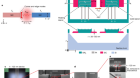
Next, we assessed how stable these slopes might be in various scenarios of urban expansion and climate change. We used computer models to simulate tens of thousands of ‘synthetic hillslopes’ with different combinations of geology, soils and land cover. These were based on data collated from the literature, fieldwork and local expert and community knowledge. We then considered how encroaching informal housing and potential changes in the intensity and duration of rainfall would affect the stability of these slopes (see Supplementary information).
Importantly, these models are process-based — they parameterize causal relationships rather than correlations in historical data. They represent interacting physical processes and failure mechanisms, including how rain and leaking pipes alter water pressure in soils and how deforestation and slope-cutting affect a hillside’s strength.
More floods, fires and cyclones — plan for domino effects on sustainability goals
For Freetown, for example, we modelled the spread of population across areas with hillslopes ranging from 10° to 35°, as well as differing urban densities on slopes (assuming hillslopes from 10 to 100% urbanized). We quantified the destabilizing impacts of extreme rainfall, cutting, terracing, removal of vegetation and poor drainage (see ‘Freetown study’). We found that disturbed hillsides in informal settlements in Freetown start to fail at a lower angle (18°) than do natural, vegetated hillslopes (26°). Higher rainfall would push the former down to 15°. Our modelling therefore suggests that a landslide in Freetown is about five times more likely to happen in an informally built area than on a natural hillside, and climate change boosts the likelihood of landslides by another 50%.
Our models also account for uncertainties in hydrological and geotechnical properties. This is crucial in regions where local data on soils and other properties are scarce. If the assessed range of slopes is found to be stable over and above such uncertainty, confidence in predictions of different scenarios is high8.
Similar analyses would allow disaster-risk policymakers to anticipate hotspots of landslide risk and prioritize funding for mitigation9. At city level, decision-makers could assess the relative importance of drivers of landslide hazards, such as deforestation versus terracing. They could infer the effectiveness of various measures to stabilize hillsides — including reforestation, limiting the angles of cut slopes or improving surface water management — and target these measures to the places where they would be most beneficial. In Freetown, for example, our analyses support reforesting steep slopes in upper catchments and installing roof guttering and surface-water drainage in dense settlements, in partnership with communities.

Severe rainfall in February triggered a landslide and flash flooding in Petrópolis, Brazil.Credit: Carl De Souza/AFP/Getty
Next steps
What needs to happen to achieve this?
Data and models. Disaster-risk assessments have advanced in the past decade owing to improved satellite and remote-sensing observations of global rainfall, land cover and information on landslides, as well as more accurate digital elevation models and open-data initiatives. A new generation of risk maps (including NASA’s Global Landslide Catalog and ThinkHazard! from the Global Facility for Disaster Reduction and Recovery) indicate broad zones of risk — for example, whole cities.
The next stage is to capture slope features, soil properties, rainfall dynamics and urbanization processes at finer scales. These can be put into process-based models, such as ours, to account for data uncertainties, future scenarios and interacting processes. The data sets needed to run such models need to be shared within and across public and private sectors. Open-source approaches should be encouraged, following protocols on data co-creation, quality control, curation, licensing and distribution such as those set out in the Open Data for Resilience Initiative. Local knowledge needs to be included.
One criticism of process-based models is the level of computational resources and skilled people needed to run them. Cloud computing gets around the first problem. To widen access, researchers could produce a shared catalogue of model outputs corresponding to a vast combination of settings (including soils, climate and slopes) and tests of mitigation actions. Users could then compare scenarios to quantify the effectiveness of possible landslide mitigation strategies while considering social and environmental costs and benefits.
Deploy heat officers, policies and metrics
To build trust, researchers need to evaluate and compare models and data sets. Model outputs must be stewarded and communicated carefully, along with uncertainties, assumptions and limitations. These must be understood by people from a wide range of backgrounds and levels of expertise, yet not unnecessarily worry those who live in areas deemed at-risk. Risk assessments must be recognized as sensitive, with implications for residents as well as political and economic ramifications.
Policy and practice. Process-based models can help disaster risk reduction consultants, city planners, engineers and those involved in community development to identify ‘low-regrets’, cost-effective solutions that holistically address interacting risk drivers under modelled scenarios. Examples include: partnering with communities to plant vegetation and install roof guttering, rainwater tanks and drainage networks. Such projects would also reduce erosion and flash flooding, improve water supplies, strengthen local capacity and enhance building practices. They might be run as part of programmes to upgrade informal settlements, which also provide infrastructure and land tenure.
The legal consequences of working in informal settlements should be addressed. If slopes can be made safer, then engineers and planners should be able to work in ‘illegal’ settlements without compromising their professional standing. If models suggest that slopes will become too dangerous to inhabit, policymakers need to consider carefully how to relocate those communities.
Decision makers should aim to use disaster risk reduction funding and policies to develop ‘pro-poor’ approaches to landslide resilience, by listening to and helping vulnerable people in their region6. Reorienting city planning away from top-down approaches, towards joint government–community working groups is key. Good examples can be seen in Quito6 as well as in Medellín in Colombia10 and Kathmandu in Nepal6. Such approaches are aligned with the United Nations Sustainable Development Goals, efforts by the International Consortium on Landslides, and initiatives such as ‘100 Resilient Cities’.
Landslide risks will be lowered only if everyone collaborates to understand and address the social, physical, political and economic drivers together.
 Five ways to ensure flood-risk research helps the most vulnerable
 More floods, fires and cyclones — plan for domino effects on sustainability goals
 Fuel crisis: slash demand in three sectors to protect economies and climate
 Deploy heat officers, policies and metrics