Volume 11
-
No. 12 December 2018
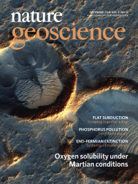
Oxygen solubility under Martian conditionsThe image shows a region in Acidalia Planitia near the equator, where dioxygen solubilities meet large dioxygen solubility gradients.
See Stamenković et al.
-
No. 11 November 2018
Speleothem record of interglacial sea levelA sea-level record from Mallorca shows no evidence of large, millennial-scale oscillations during the last interglacial. The image shows speleothems that have grown on submerged stalactites, as well as submerged stalagmites.
See Polyak et al.
-
No. 10 October 2018
Recurring intraplate earthquakesA pair of closely spaced intraplate earthquakes in Japan can be explained by postseismic deformation associated with the 2011 Tohoku-Oki earthquake. The image shows the displacements caused by one of the two earthquakes.
See Fukushima et al.
-
No. 9 September 2018
Volcanic gas bubbles oxidize as they riseThe chemical composition of volcanic gases emitted from volcanoes depends on the size of gas bubbles rising through the magma to the surface, as revealed by spectroscopic observations at the lava lake of the Kīlauea Volcano (pictured) in Hawaii, USA.
See Oppenheimer et al.
-
No. 8 August 2018
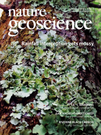
Rainfall interception gets mossyNon-vascular vegetation, such as lichens and bryophytes, can intercept and store substantial amounts of precipitation at a global scale, suggest numerical simulations and comparisons to field observations. Such non-vascular forms of vegetation live on nearly all land and plant surfaces, such as the tree pictured.
See Porada et al. and News & Views by Savenije
-
No. 7 July 2018
Archaean continental spreadingGiant crustal spreading structures are preserved in the Yilgarn Craton, Australia, according to analyses of seismic images from the region. The structures may have formed over 2.5 billion years ago when the cores of continents were hot and weak. The image shows the bedrock geology map, draped over shaded relief from the reduced to pole total magnetic intensity field (north up).
See Calvert et al.
-
No. 6 June 2018
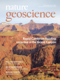
Rapid Cambrian flooding recorded in the Grand CanyonExtensive flooding of the North American continent during the Cambrian occurred more recently and more rapidly than previously thought, according to analyses of detrital zircons sampled from the Grand Canyon region. The image shows rocks deposited about 500 million years ago, during the flooding, overlying rocks that are more than a billion years old. The rock units are separated by the Great Unconformity and are today exposed in the Grand Canyon.
In the original version of this summary, 'earlier' was mistakenly used instead of 'more recently'. This has now been corrected in the online version.
See Karlstom et al
-
No. 5 May 2018
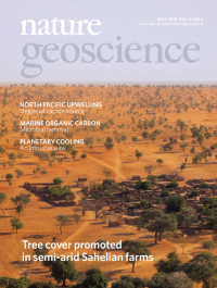
Tree cover promoted in semi-arid Sahelian farmsFarmland management promotes tree cover around villages in the semi-arid Sahel of West Africa, according to analyses of satellite imagery. This implies that a higher population density does not always lead to reduced tree cover. The image shows tree cover around settlements in the African Sahel.
See Brandt et al and N&Vs by Hanan
-
No. 4 April 2018
Atmospheric mercury levels affected by vegetationTerrestrial vegetation contributes to the seasonal variation of atmospheric mercury concentrations, according to analyses of satellite data. The data show that changes in photosynthesis and vegetation cover correlate with atmospheric mercury. The image shows autumnal foliage in UK woodland.
See Jiskra et al.
-
No. 3 March 2018
Spinning up Saturn‘s cyclonic circulationSaturn‘s cyclonic atmospheric circulation may be explained by the dynamics of small-scale convection, suggest laboratory analogue experiments. The image shows the surface signature of a heated fluid rising from the base of a rotating fluid layer in a laboratory experiment that simulates a planetary atmosphere.
See Afanasyev & Zhang
-
No. 2 February 2018
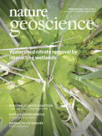
Watershed nitrate removal by interacting wetlandsDepending on their connectivity to the river network, wetlands can be much more efficient at removing nitrate in a watershed than common nitrogen mitigation strategies according to an analysis of the Minnesota River basin. The image looks down through the vegetation in one of the many wetlands in the Minnesota River basin.
See Hansen et al.
-
No. 1 January 2018
Fresh fjord water from iceberg meltIceberg melt is the largest annual freshwater source in a South Greenland fjord, with release largely below 20-m depth, according to iceberg-model simulations. Furthermore, iceberg melt peaks later in the year than other sources of freshwater. The image shows an iceberg in Sermilik Fjord, East Greenland in July 2017.
See Moon et al. (2017)