
World Wind Moon, released in October 2005, was made off the back of World Wind Earth. Was it hard to make the leap off this planet?
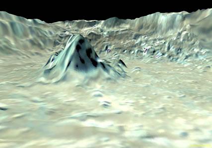
 Fly around the Moon and have a look at the dark side.NASA World Wind
It was a piece of cake really. We got our hands on imagery and elevation data from NASA's 1994 Clementine mission. It was mostly a matter of processing all that, and georectifying the images with coordinate data to place them correctly. Then once you add in the elevation and terrain data, the user is able to navigate in three dimensions through the Moon terrain, just as in the Earth version. Most of the imagery is at 100-metre resolution, but about 10% is at 20-metre resolution. There are also shaded elevation data, provided by the US Geological Survey, which has different colours for elevation, so that the mares [lunar 'seas' of old lava floods] stand out against higher structures.
What's the most striking thing about the virtual Moon software?
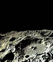
 The programme lets you see exaggerated elevations inside places such as Tycho crater (shown).NASA World Wind
I think the most fun aspect is to be actually able to visit the far side of the Moon. We are so familiar with the Moon, and we say, "hey, that's beautiful," but when you think about it we always see the same face of the Moon. This for me is the biggest mass appeal; it is quite exceptional.
Is it useful for scientists too?
It's an excellent tool for astronomers, and geologists, to view Moon data. And because World Wind is a free and open source, anyone can take it and add their own data, or build new applications on top. So I feel that the European Space Agency would be delighted to take World Wind and add its SMART-1 imagery [The SMART-1 mission ends September 2006].
We are focussed on developing World Wind as a software platform for scientists and others to use to view their data. It's evolving fast and in a year or so is going to be absolutely phenomenal.
What's next for World Wind?
 Read our Moon special to find out more.NASA
The biggest changes coming up, this month, will be adding shading and lighting for the Earth version. The Sun will be in its correct position, and the shadows on Earth will be where they are supposed to be. If you go down into the atmosphere, you will be able to see sunrises and sunsets. We are adding three-dimensional volumetric clouds, and light and colour will be reflected upon the clouds, which will then also be reflected on the land, and on the correct side of the mountains. It's absolutely gorgeous; we are getting towards reality. If you ask me, World Wind will soon be the video-game graphics engine of choice.
Any plans for Universal domination?
In terms of planetary data, we will soon add some data from the [1966-67] Lunar Orbiter missions. We already have globes for Jupiter, Mars and Venus. The Sloan Digital Sky Survey is using World Wind to map the entire sky with images at the resolutions of the Hubble Telescope.
Visit our newsblog to read and post comments about this story.
