Thank you for visiting nature.com. You are using a browser version with limited support for CSS. To obtain
the best experience, we recommend you use a more up to date browser (or turn off compatibility mode in
Internet Explorer). In the meantime, to ensure continued support, we are displaying the site without styles
and JavaScript.
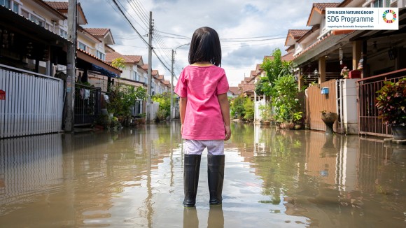
Flooding represents one of the most widespread and damaging natural hazards on the planet and one that looks set to get worse with projected anthropogenic climate change. In this Collection, we explore the natural processes that drive flood hazard, the social and environmental factors that can exacerbate vulnerability and the measures that can be taken to assess and mitigate flood risks.
This Collection supports and amplifies research related to SDG 13: Climate Action.
Can flood hazards be predicted precisely and accurately at the scale of individual buildings? A consideration of the uncertainties in most inundation modelling suggests not.
To prevent floods from becoming disasters, social vulnerability must be integrated into flood risk management. This Comment advocates that the welfare of different societal groups should be included by adding recovery capacity, impacts of beyond-design events, and distributional impacts.
Geological and botanical archives can preserve evidence of exceptional floods going back centuries to millennia. Updated risk guidelines offer a new opportunity to apply lessons from paleoflood hydrology to judge the odds of future floods.
An approach to predict realistic spatial surfaces of extreme storm surge event probabilities and their uncertainty along the contiguous United States coastline is developed using stochastic generation of synthetic extreme surges at the gauged and ungauged gridded locations.
Merging flood impact data from Landsat, Sentinel-2, and Sentinel-1 satellites boosts useful flood image coverage from 7% to 66% across all flood types, and would greatly increase the percentage of displaced populations served by high-resolution images
European river discharge observations suggest that catchments with similar flood generation processes produce similar extremes, enabling better predictability of megafloods using a continental scale perspective.
Effective flood response management relies on rapid high-resolution and high-accuracy flood inundation predictions. This study develops a low-fidelity model and upskills its predictions, greatly reducing the computational time while maintaining a high resolution and accuracy comparable with a high-fidelity model.
Rivers are important reservoirs of plastic pollution. This study demonstrates that fluvial floods drive macroplastic transport and accumulation in rivers with unique observational evidence during the July 2021 flood along the Dutch Meuse River.
According to a modelling framework for forecasting coastal hazards, wave runup contributes an average of 73% of the total water level during dune erosion events in the Eastern USA, which suggests models that neglect the wave component underestimate the hazard.
Extreme flood risk can be predicted based on stream network organization and flow regime, according to analysis of hydroclimatic observational records.
How will climate change affect wet and dry extreme events around the world? On the basis of terrestrial water storage observations and a novel clustering algorithm, this study shows that the intensity of such events has been increasing with global warming.
Changes in the processes that can generate floods, such as rain falling on wet rather than dry soil, affect the occurrence of regional floods more than changes in extreme rainfall, according to an analysis of flood anomalies observed in Europe combined with a flood process typology.
Temporal clustering of rainfall events was the dominant driver of flooding at Lake Como between 1980 and 2020, according to an analysis of historical and meteorological data on past flooding events which highlights the importance of compound mechanisms
The time and magnitude of flood crests in rivers can be forecast using direct streamflow measurements alone, according to an index-velocity forecasting algorithm applied to in situ data from the Illinois River, USA
Moderate flooding in the European Alps declined during past warmer periods, whereas extreme floods both increased and decreased, according to an analysis of palaeoflood records.
Concurrent coastal extremes - storm surges and flooding from precipitation - are 2.5 times as frequent in latitudes higher than 40∘N under a high emission scenario by 2100 compared to today, according to an analysis of climate and ocean model output.
The disparity in access to shelter undermines the resilience of the urban population in the USA to flood risks and highlights the need for shelter planning to ensure effective disaster response, according to an analysis combining measures of flood risk and access to shelter
Cities in the United States are adapting to flood risks, yet over half of high-risk cities remain underprepared; financial constraints and short-term planning are barriers to adequate adaptation, according to analysis of financial disclosure data.
Managed realignment is more effective at mitigating coastal flood risk than raising dike heights according to hydrodynamic models of the German Baltic sea coast, but neither will be able to maintain current levels of flood risk under future sea level scenarios
Significant differences between probabilistic and deterministic flood hazard assessments emphasize the need for improved quantification of uncertainties in flood risk management, according to an integrated floodplain modelling system applied to the Duero River in Spain.
This study presents a global analysis of the sensitivity of inundated areas and population exposure to varying flood event magnitudes globally for 1.2 million river reaches. The authors show that topography and drainage areas correlate with flood sensitivities as well as with societal behavior.
While flood risk in coastal West Africa will be dominated by sea level rise for the first half of the 21st century, socioeconomic development will control flood risk during the second half, according to numerical modelling coupled with population and asset exposure estimates
Coastal flood risk to transit infrastructure in Boston, USA, has more than doubled in terms of annual economic losses since 2008 and will double again by 2030, according to a cost estimation framework based on Monte Carlo simulations.
Networks of coastal flood sensors are effectively located by following a multi-objective optimization approach that considers hazard estimations, serviceability, and social vulnerability, as well as the more traditional measures of coverage and uncertainty
Shanghai is a city facing the challenge for flood defence under climate change. This study proposes engineering solutions for mitigation flood risks in Shanghai by incorporating regret theory and decision science into the dynamic-adaptation-pathways framework.
Floods are most devastating for those who can least afford to be hit. Globally, 1.8 billion people face high flood risks; 89% of them live in developing countries; 170 million of them live in extreme poverty making them most vulnerable.
Flood impacts on the functioning of a transport network are substantially exacerbated by indirect effects such as congestion due to changing traffic patterns, suggests an analysis of the impact of Hurricane Harvey on transport in Harris County, Texas using network percolation theory.
Just under 200 million people are exposed to 1 in 1000-year coastal flooding events, about 31% more than previously estimated, according to a combination of numerical simulations which account for low-probability but high-impact tropical cyclones
A global analysis of income inequality and flood disasters in middle- and high-income countries between 1990 and 2018 shows that unequal countries tend to suffer higher flood fatalities.
Numerical tools for flood forecasting and for designing coastal protection schemes require accurate real world data on speed and volume of overtopping waves on sea walls. Margaret Yelland and colleagues here describe the validation and field deployment of arrays of capacitance sensors, termed Wirewall, as a tool for acquisition of detailed data of coastal overtopping.
An assessment of ice-dam failures in six mountain regions shows that extreme peak flows and volumes have declined sharply since 1900, and that ice-dam floods today originate at higher elevations and earlier in the year.
Climate change is expected to intensify the hydrological cycle, but how this translates into changes in river floods is not clear. Here, the authors show that changes in river flood discharge differ between flood types, with increases in rainfall-induced floods and decreases in snow-related floods.
The risks to human well-being of floods in the United States have long been overlooked and underestimated, particularly for low-income and marginalized communities. In Los Angeles, flood risks are disproportionately high for historically disadvantaged populations and communities already facing social inequities.
The National Flood Insurance Program is a key tool for managing growing flood risk in the USA. This research shows that premiums based on local risk, rather than national averages, will generate large societal benefits, and investments in large-scale adaptation infrastructure will enhance these impacts.
Unprecedented floods and droughts bring new challenges for risk reduction, as is clear from this analysis of the drivers of changing impacts in many cases worldwide, with implications for efficient governance and investment in integrated management.