- WHERE I WORK
How I use tide gauges to develop geospatial maps

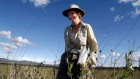
Muh Aris Marfai is head of the Geospatial Information Agency of Indonesia in Bogor and a geography researcher at the Gadjah Mada University in Yogyakarta. Credit: Gaia Squarci for Nature
Access options
Access Nature and 54 other Nature Portfolio journals
Get Nature+, our best-value online-access subscription
$29.99 / 30 days
cancel any time
Subscribe to this journal
Receive 51 print issues and online access
$199.00 per year
only $3.90 per issue
Rent or buy this article
Prices vary by article type
from$1.95
to$39.95
Prices may be subject to local taxes which are calculated during checkout
Nature 628, 228 (2024)
doi: https://doi.org/10.1038/d41586-024-00908-w
This interview has been edited for length and clarity.
 I started fossil hunting in my 60s — now I have more than 2,000 pieces
 Economists count the cost of ‘risky’ science
 How I learnt to write research papers as a non-native English speaker