


« Prev Next »
The ancient Greeks believed that west winds were blown by the god Zephyrus and that lightning strikes were thrown by Zeus. Applying the laws of physics to observations of our atmosphere gives us a more modern explanation for these two phenomena: ultimately, they are both caused by the uneven heating of the globe by the sun.
When air is heated in a particular location, it expands and becomes less dense. This generates an upward (buoyant) force on the air, as it is lighter than an equal volume of unheated air. Since most sunlight penetrates to the ground, during the day air near the ground is heated and this gives rise to convection as the heated air rises away from the heat source and cooler air from above sinks to take its place. Often this convection reaches a couple of kilometers above the surface (causing for example the turbulence often felt in an airplane during daytime takeoffs and landings).
The buoyant air exerts a slight pull on the air below, creating a region of low air pressure nearer the surface. This deficit relative to pressure farther away at the same altitude creates a pressure-gradient force that pulls air inward to fill the space vacated by the rising, buoyant air. The reverse happens above, where air is pushed outward. The difference between the ‘pulling' and ‘pushing' forces is proportional to the buoyancy.
Air that rises far enough will experience condensation of water vapor into a cloud, which further heats the air by releasing latent heat. In a sufficiently unstable local atmosphere, this causes the convection to reach far higher, and to condense large amounts of water vapor, which fall as rain showers.
If the rising motions are very rapid (at least 7 m/s), large amounts of this condensed water can be held in suspension against gravity at altitudes above the freezing level. Collisions between frozen and partially frozen particles can then transfer electric charges, producing lightning — a more readily observable sign of strong upward motion (Zipser & Lutz 1994).
The amount of rain is directly proportional to the net latent heating of the air. It is primarily by this process that the solar heat deposited at the surface is continually transferred to the atmosphere.
The heat so transferred (whether by thunderstorms or other cumulus clouds) is generally greater where solar heating is stronger, that is, in the tropics and in summer. Air correspondingly tends to rise in tropical locations and over continents in summer and oceans in winter (oceans have enough heat capacity to store much of the summer heat and release it in winter).
The extra heating of the land produces the summertime monsoon circulations that occur over many continents. The inflow of low-level, humid air to replace the rising heated air ends up producing the massive rains that we associate with monsoons. Asia experiences the most dramatic monsoon, but northern Australia and parts of South and North America all experience lesser versions.
A monsoon, however, is not quite this simple. As the air near the surface converges toward the heated region due to the low pressure there, it is deflected by the Coriolis pseudo-force arising from the Earth's rotation. In the northern hemisphere this ‘force' deflects the air to the right, and in the southern hemisphere, to the left. As a result, the air spirals in a counterclockwise sense (in the northern hemisphere) rather than flowing straight in. A similar flow occurs as air spirals into a mid-latitude or tropical low-pressure system (the reason they are called cyclones). Aloft, air spirals outward in a clockwise sense. Since the Coriolis force always points at right angles to the velocity, one might expect the air to simply go around in circles. However, this would be overlooking the pressure-gradient force that got the air moving in the first place. If that force is maintained steadily in the same direction, an interesting thing happens. The air continues to be deflected by the Coriolis force, until it is flowing at a right angle to the pressure gradient. At this point these two forces are in a geostrophic balance, such that the air continues in an approximately straight line with no net acceleration in either direction (see Figure 1). Mathematically, air is obeying Newton's law, which can be written
du/dt = fv -αdp/dx - Fx
where u and v are the eastward and northward velocities, du/dt (the ‘momentum term') is the eastward acceleration experienced by the air as it moves, f=4πsinλ day-1 is the Coriolis parameter where λ is latitude, p is pressure, α is the reciprocal of air density, and Fx is the deceleration due to friction. A similar equation holds for the northward acceleration dv/dt. Geostrophic balance occurs when the momentum and friction terms are negligible in both directions.
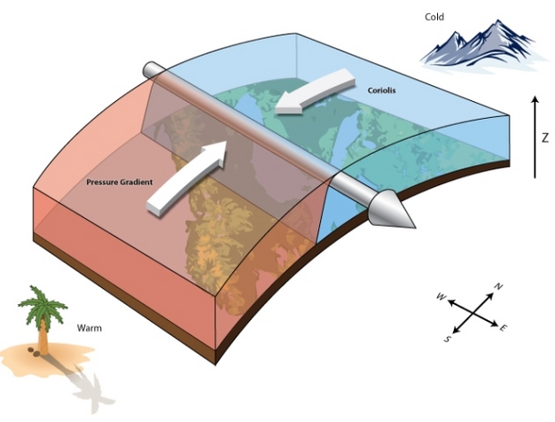
Figure 1
A geostrophically balanced wind (cone-headed arrow) aloft (e.g., jet stream) in the northern hemisphere. The only forces acting on the wind are the pressure gradient (green arrow) and the Coriolis pseudo-force (red arrow). The air below wind level is typically warmer to the right of the motion and colder to the left (in the southern hemisphere this would be opposite), creating the pressure gradient at wind level.
© 2013 Nature Education All rights reserved. 
Airflows aloft that last for several days or longer tend to achieve an approximate geostrophic balance. The main example is the global jet streams, which flow aloft (roughly 12 km altitude) from west to east. The poleward pressure gradients that sustain them are generated by the warm and buoyant tropical air below the jet level. Thus, it is again the uneven heating of the planet by the sun that ultimately gives rise to these winds. The westward trade winds near the surface are an indirect consequence: as low-level air is pulled equator-ward, it also accelerates westward from the Coriolis force; and having lost (due to turbulence) some of the eastward momentum that it earlier acquired aloft, it ends up with westward velocity.
The geostrophic wind distribution becomes unstable in mid-latitudes, giving rise to mid-latitude cyclones. Moreover, winds are seldom in perfect geostrophic balance owing to friction and/or inertia. When friction is present, in particular near the ground, this third force retards the wind and prevents the Coriolis force from fully balancing the pressure gradient. The wind thus retains a component that points toward the low pressure, in contrast to the purely geostrophic limit. The trade winds are an example, as is the spiraling inflow into a mid-latitude or tropical cyclone. In cyclones, the three forces do not exactly balance each other: a net centripetal acceleration is needed to make the air follow its curved path. In tropical cyclones this acceleration must be strong enough to drive convergence toward the eye wall (see Figure 2).
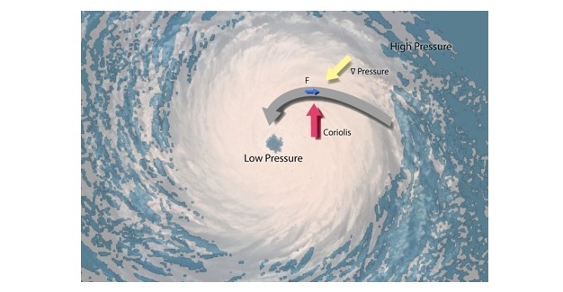
Figure 2
Near-surface wind converging into a low-pressure system. A modest friction force allows the velocity to have an inward component rather than being geostrophic, and the resultant of all forces is nonzero and toward the centre of the storm, causing wind to spiral. The wind speeds up during the air’s inward spiral, especially in a tropical cyclone (pictured).
© 2013 Nature Education All rights reserved.
Coriolis forces are crucial in forming the more persistent wind patterns, but become less important for more transient phenomena. In tropical and mid-latitude cyclones, for example, all terms can be important. In isolated convective storms, the Coriolis force is overwhelmed by the others and can be ignored, but, on the other hand, momentum becomes important in the vertical direction. Newton's law for the upward air speed w becomes
dw/dt = -αdp/dz - g - Fz
rather than the simple hydrostatic balance (where the momentum and friction terms are negligible) that holds for larger scales.
The minimization of the Coriolis force might seem to make small-scale phenomena like thunderstorms easier to understand than large-scale flows, but in fact the opposite is true, because the stronger vertical motions and weaker rotation produce complex turbulent phenomena. While turbulence affects all geophysical flows (for example, helping explain the westward trades as noted above), it is particularly important in atmospheric convection.
If cloudy air is warmer than its surroundings and all air is initially at rest, -dp/dz will exceed g, implying a net upward buoyant acceleration; when a hydrostatic calculation predicts this we say the air is convectively unstable. Traditional thinking holds that this buoyancy-dominated instability determines storm severity. But since air is not at rest, pressures can be affected by factors other than buoyancy, including resistance from the ambient air that must be pushed out of the way, or the effects of neighbouring clouds. Furthermore, buoyancy itself is reduced by turbulent mixing between air inside and outside the cloud, a process that is difficult to model (Heus et al. 2008). Friction forces are typically assumed to be strong for small drafts in convection, but cannot directly be measured, and could be small in some circumstances. The degree of mixing and friction significantly affect the maximum height calculated for situations of apparent convective instability (Figure 3).
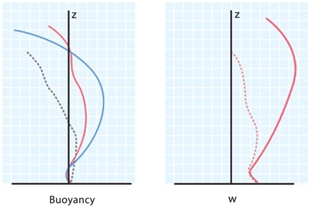
Figure 3
Schematic illustration of the (a) upward buoyancy force on a rising air parcel expected from its lower density (neglecting air motions), if it rises without mixing (blue line), with mixing in a 100% relative humidity environment (red line), and with mixing in a low-humidity environment (black line); (b) ascent speed w arising from the humid mixing (red) case from (a), with no friction (solid) and with friction (dashed).
© 2013 Nature Education All rights reserved.
Recent work suggests that pressure-gradient forces independent of buoyancy may explain why the strongest storms are mostly restricted to continents and large islands rather than over oceans. During the day, heating near a coast warms the air above; this air then rises as part of a sea breeze circulation, with cooler marine air intruding over the land (Figure 4). The most severe convection seems to occur when opposing breezes or waves collide in the afternoon (the time of maximum convective instability). This results from a heterogeneous surface, via the dynamics of density currents and/or waves (Robinson et al. 2011), giving dynamics a fuller role that has yet to be incorporated in heuristic models of the phenomenon.
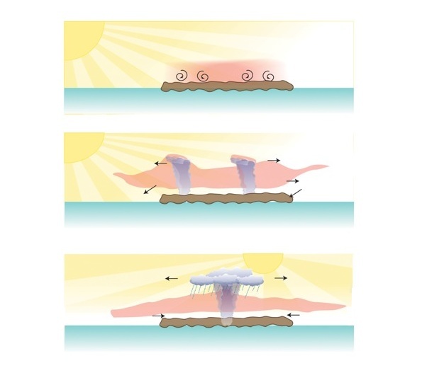
Figure 4
Development of convection in response to the solar-induced sea breeze. Heating of the ground drives shallow convection and is spread upward (first panel); this air rises and spreads out while marine air flows in near the ground, the head of this current triggering some cloud deepening (second panel); strong storms can occur when fronts collide, especially in the afternoon when the ground is warmest (third panel).
© 2013 Nature Education All rights reserved.
Further research should continue to unravel the secrets of what controls the outbreak and character of cloud systems, in the Tropics and beyond. Progress in this area is crucial for continued improvement in weather- and climate-forecasting accuracy. Until then, important phenomena ranging from tomorrow's thunderstorms to next season's rainfall totals, although not as hard to predict as the mercurial behavior of the gods, will often continue to surprise us.
References and Recommended Reading
Heus, T. et al. Mixing in shallow cumulus clouds studied by Lagrangian particle tracking. Journal of the Atmospheric Sciences 65, 2581-2597 (2008).
Robinson, F. J. et al. Exploring the land-ocean contrast in convective vigor using islands. Journal of the Atmospheric Sciences 68, 602-618 (2011).
Zipser, E. J. & Lutz, K. R. The vertical profile of radar reflectivity of convective cells--- a strong indicator of storm intensity and lightning probability? Monthly Weather Review 122, 1751-1759 (1994).