


« Prev Next »

"All was a-shake and a-shiver — glints and gleams and sparkles, rustle and swirl, chatter and bubble. The Mole was bewitched, entranced, fascinated."
So begins a passage from The Wind in the Willows by Kenneth Grahame. The excited mole runs along the riverbank marveling at the wonderful and curious behavior of the water in the river. We can experience the same wonder and fascination when we encounter rivers and streams; each one is different and unique — so let's discover what makes rivers, and the study of river systems, or fluvial geomorphology, amazing and unique. One of the most intriguing aspects of the water on Earth is that it is rarely created or destroyed within the Earth System. It is simply transformed and transferred as part of Earth's dynamic hydrologic cycle. Water molecules are in constant motion from one location and physical state to another.
Rivers are a dynamic combination of water, sediment, aquatic organisms, and riparian vegetation, all participating in a complex dance from the point of origin, or headwaters, toward the ocean or basin where the journey ends. The changes that occur along the way have been described in terms of a continuum by ecologists (Stanford & Ward 1993, Montgomery 1999), through quantifiable variables such as slope and width by geomorphologists (Schumm 1984), and through concepts of landscape evolution by tectonic geomorphologists (Burbank & Anderson 2001).
The shape of rivers and streams changes through time as erosion, deposition, and transport of sediment occurs. Rivers and streams maintain a dynamic equilibrium between discharge, slope, sediment load, and sediment size (Lane 1955). Long-term shifts in equilibrium observed in the landscape can result from climate change, tectonic uplift and subsidence, local base-level changes due to landslides and damming, and hydrologic changes resulting from human activity such as dams and irrigation diversion. Base level is defined as the imaginary horizontal level or surface to which sub-aerial erosion proceeds (Schumm 1993). Several models to describe the evolution of river morphology have been proposed. Davis (1899) viewed the rivers on the Colorado Plateau of the United States as progressing from youthful to old age life stages. Davis (1902) also introduced the concept of a graded stream, where erosion and deposition are in balance. Mackin (1948) described a graded stream as "one in which, over a period of years, slope is delicately adjusted to provide, with available discharge and with prevailing channel characteristics, just the velocity required for the transport of the load supplied from the drainage basin." More recently researchers have used complex computer models to understand landscape evolution through a balance between tectonic uplift (mountain building) and denudation (erosion) processes (Burbank & Anderson 2001).
Why is it important to understand and learn about rivers? Since the earliest recorded human history, rivers have been the lifeblood, highways, and pantries of the world. Settlements and towns have emerged and thrived near rivers and streams because of the water they contain, the transportation they provide, and the life that they support. They are dynamic, interesting, and beautiful; but they can also be dangerous and unpredictable. Immovable human settlements and towns located near rivers are often in conflict with the natural and dynamic nature of many river systems. This geographical collision sometimes results in catastrophic loss of property and life. On the evening of July 31, 1976, residents of Big Thompson Canyon in Colorado tragically learned the power of rivers to transform from serene picnic locations to raging torrents capable of amazing destruction. Thunderstorms hovered over the watershed of the Big Thompson Canyon dropping over a foot of rain in a period of three hours (http://www.noaanews.noaa.gov/stories/s688.htm). A wall of water 19 feet high carrying huge boulders raged into the town killing 145 people in a matter of minutes.
Rivers, although potentially dangerous, also possess great power that can be harnessed for many beneficial uses including commerce, hydroelectric power generation, and irrigation of farmland. The largest river in the United States, the Mississippi River, provides an important commercial route for goods and services from the entire Midwestern United States. The power of the river exists as kinetic energy, the amount of water passing a given point (discharge) and vertical distance that water falls (hydraulic head) determine the amount of power that can be generated. The majority of the large hydroelectric projects in the United States are in the mountainous western states of Oregon, Washington, Idaho, and California. The Corps of Engineers maintains a database of dams in the United States where you can learn more.
The recovery of energy from rivers and streams through the construction of dams comes at a cost to ecosystems and the function of river systems. Dam construction can result in changes to sediment transport, aquatic ecosystems, and migratory fish species such as salmon and steelhead trout (Grant et al. 2003, Collier 2000). The capture of sediment behind dams can have profound impacts on the geomorphology and function of the river downstream from the dam. The water released below the dam has been termed "hungry water" because it has sufficient energy to transport sediment but the sediment has been captured behind the dam (Kondolf 1997). The "hungry water" consumes the bed and banks of the river below the dam, resulting in entrenchment and armoring of the bed (Figure 1). Efforts are underway at many dams in the northwestern United States to mitigate for the interception of sediments by adding sediment, referred to as augmentation, below dams. This process replaces all or part of the sediment load carried by the river prior to dam construction so that sufficient sediment is available below the dam for spawning fish, habitat structures, and ecosystem function (Figure 2). The size of the gravel added varies depending on the goals of the gravel augmentation plan. Gravel for spawning gravel is typically 14–35 mm, while a range of sizes may be used to restore geomorphic structure (gravel and sand bars) is desired (Kondalf & Wolman 1993).
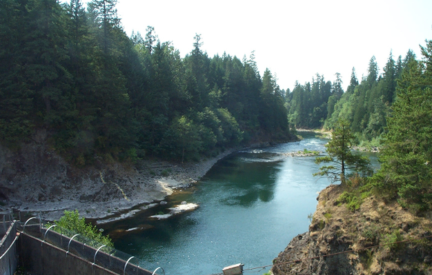
Figure 1: Entrenchment and absence of sediment below River Mill Dam on the Clackamas River in Oregon.
The left bank is bedrock and gravel storage in bars is almost non-existent.
© 2012 Nature Education All rights reserved. 
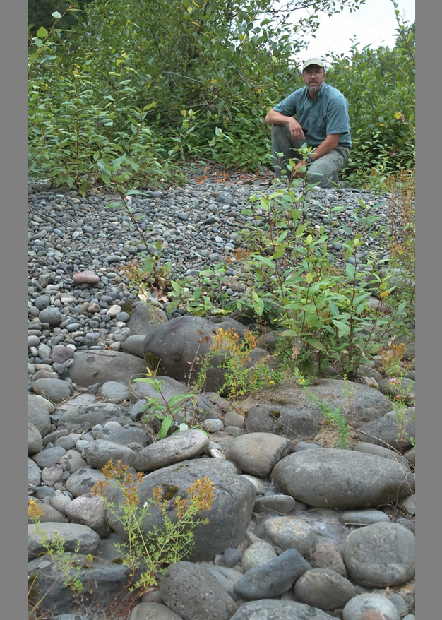
Figure 2: Spawning size gravel added to the Clackamas River (upper part of photo) in 2003.
Part of a pilot project to restore normal sediment transport and replenish spawning gravel beds downstream of the dam (Photo taken in 2010).
© 2012 Nature Education All rights reserved.
The detention of water behind the dam can also have profound impacts on aquatic ecosystems. For example, when Hoover Dam was constructed in Arizona, it created the largest reservoir in the United States. Due to its size and depth, the water in Lake Mead is not warmed by solar radiation as much as the Colorado River was prior to the dam construction. As a result, the water released below the dam is significantly colder, and the aquatic species populations below the dam have been profoundly changed (Marsh 1985). Fish populations formerly dominated by warm water species are now dominated by cold water trout species below the dam for several miles.
Rivers and streams also provide crucial pathways for aquatic and terrestrial organisms to move and migrate to find food and avoid predators. Riparian corridors can be 100's of kilometers wide or mere centimeters. Anadromous species take advantage of the aquatic highways to migrate and spawn in regular cycles tied to rainfall and seasons. For example, in the Pacific Northwest salmon migrate into river systems and travel upstream to the headwaters where they were born. The salmon spawn and lay their eggs in the gravel bed of the stream. The salmon fry emerge and travel downstream to the ocean where they grow and feed until it is their turn to return to their birth waters and spawn. Dams and other modifications to river systems can prevent salmon, and other anadromous species, from returning to their birth streams. Turbines used to generate power at dams are harmful to the smolts, or young salmon, as they attempt to return to the ocean. Estimates vary for each dam and river system, but as much as 10% of the smolts can be killed by turbines from a single large dam. If a river system has multiple dams the impact can be devastating to anadromous fish populations.
Humans have modified many rivers and streams to the point where they no longer provide valuable ecosystem and aquatic corridor functions. Watershed groups, government agencies, and non-profit groups are playing a critical role in restoring river functions through watershed plans and restoration activities. In order for river restoration efforts to be successful, it is necessary to understand what the river morphology and function was prior to human modification (i.e., what did the river look like and how did it function before modification?). Only after understanding and agreement is reached on prior conditions can restoration activities begin to restore function and morphology. Two broad conceptual approaches to restoration are typically used for restoration design and implementation: 1) hydraulic engineering and erosion resistant structures (Shields et al. 2003), and 2) reference reach mimicry and soft structures composed of vegetation and natural materials (Rosgen 1996). Montgomery (2002) combines elements of both of these conceptual approaches to arrive at a method which considers both quantitative geomorphic parameters and reach-specific characterization (Montgomery & Buffington 1997, Montgomery & MacDonald 2002). Because rivers are dynamic and changing, restoration must allow for the river to remain dynamic to be successful in the long term. The hydraulic engineering approach typically involves detailed numerical modeling of the river systems using tools such as HEC-RAS (Brunner 2002) to model water velocities under different flow regimes so that stable structures can be engineered. This approach typically requires extensive cross-section surveys and assumptions about model parameters such as bed roughness (Manning's n value). The reference reach approach has become more common in the last two decades, partly in response to a failure of some engineered structures built within dynamic river systems. This approach, championed by David Rosgen, involves classifying the river system to be restored based on a number of metrics related to channel form such as width to depth ratios, bed composition, and other variables that characterize a stream reach (Rosgen 1994). Once the river or stream has been classified, a reference reach is subjectively chosen as the goal of the restoration plan and reshaping and revegetation transform the impacted reach into a river or stream which mimics the reference reach parameters. Advocates for this approach argue that it is more compatible with the unpredictable and dynamic nature of rivers, while advocates of the hydraulic engineering approach argue that the numerical certainty provided by the computer models provides better restoration solutions.
A wealth of data and information about rivers is available on the internet. One of the most interesting and compelling data sources is the United States Geologic Survey web site where river flow for thousands of rivers across the Unites States can be viewed in real-time on a color coded map. A series of excellent, on-line activities, to learn about flood frequency and discharge are also available at the Virtual River web site. The next time you find yourself walking along a river bank, take time to explore for yourself and see what you can learn about these dynamic and beautiful places.
References and Recommended Reading
Brunner, G. W. HEC-RAS River Analysis System. Hydraulic Reference Manual. Davis, CA: United States Army Corps of Engineers, Hydrologic Engineering Center (HEC), 2002.
Burbank, D. W. & Anderson, R. A. Tectonic Geomorphology. Blackwell Science, 2001.
Collier, M., Webb, R. H. & Schmidt, J. C. Dams and Rivers; A Primer on the Downstream Effects of Dams. Reston, VA: United States Geologic Survey, 2000.
Davis, W. M. The geographical cycle. Geography Journal 14, 481–504 (1899).
————— Base level, grade, and peneplain. Journal of Geology 10, 77–111 (1902).
Grant, G. E., Schmidt, J. C. & Lewis, S. L. "A geological framework for interpreting downstream effects of dams on rivers," in A Peculiar River, eds. J. E. O'Connor & G. E. Grant (American Geophysical Union, 2003) 209–225.
Kondolf, G. M. Hungry water: Effects of dams and gravel mining on river channels. Environmental Management 21, 533–551 (1997).
Kondolf, G. M. & Wolman, M. G. The sizes of salmonid spawning gravels. Water Resources Research 29, 2275–2285 (1993).
Lane, E. W. The importance of fluvial morphology in hydraulic engineering. Proceedings of the American Society of Civil Engineering 81, paper 745, 1–17 (1955).
Mackin, J. H. Concept of the graded river. Bulletin of the Geological Society of America 59, 463–512 (1948).
Marsh, P. C. Effect of incubation temperature on survival of embryos of native Colorado River fishes. The Southwestern Naturalist 30, 129–140 (1985).
Montgomery, D. R. Process domains and the river continuum. Journal of the American Water Resources Association 35, 397–410 (1999).
Montgomery, D. R. & Buffington, J. M. Channel-reach morphology in mountain drainage basins. Geological Society of America Bulletin 109, 596–611 (1997).
Montgomery, D. R. & MacDonald, L. H. Diagnostic approach to stream channel assessment and monitoring. Journal of the American Water Resources Association 38, 1–16 (2002).
Rosgen, D. L. A classification of natural rivers. Catena 22, 169–199 (1994).
————— Applied River Morphology. Pagosa Springs, CO: Wildland Hydrology, 1996.
Schumm, S. A. River response to baselevel change: Implications for sequence stratigraphy. The Journal of Geology 101, 279–294 (1993).
————— The Fluvial System. New York, NY: John Wiley and Sons, 1984.
Shields, F. D. et al. Design for stream restoration. Journal of Hydraulic Engineering 129, 575–584 (2003).
Stanford, J. A. & Ward, J. V. An ecosystem perspective of alluvial rivers: Connectivity and the hyporheic corridor. Journal of the North American Benthological Society 12, 48–60 (1993).