


« Prev Next »
Earth is a dynamic planet, constantly undergoing change driven by internal and external forces. Currents of magma within our planet move the plates that form the continental crust in a constant process that builds mountains and creates valleys. These valleys may eventually become lakes, seas, and oceans. On the surface, the greatest factor affecting Earth is sunlight. Sun provides energy for living organisms, and it drives our planet's weather and climate by creating temperature gradients in the atmosphere and oceans.
Atmospheric Circulation
The sun's rays provide both light and heat to Earth, and regions that receive greater exposure warm to a greater extent. This is particularly true of the tropics, which experience less seasonal variation in incident sunlight. Moisture-laden tropical air warms, becomes less dense, and rises. But as air reaches the upper levels of the atmosphere, it cools. Water molecules condense to form clouds and eventually fall as rain. Warm air rising from Earth's surface pushes the air mass away from the equator, and releases its moisture as precipitation as it travels pole-ward (Figure 1).
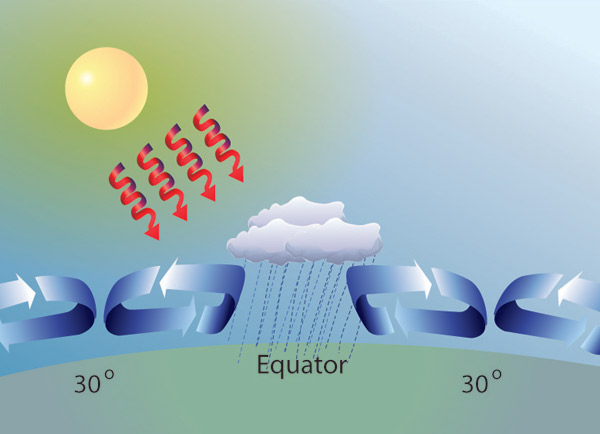
Figure 1: Cycle of evaporation, condensation, and precipitation
Areas in the tropics receive greater incident sunlight throughout the year, which causes water to evaporate. The moisture-laden air travels away from the equator, losing precipitation as it goes.
© 2011 Nature Education All rights reserved. 
If the Earth did not spin on its axis, this cycle of evaporation, condensation, and precipitation would move water and air along a north-south axis from the equator to the poles. This, however, does not happen. Earth's spin creates three belts of circulation (Figure 2). Air circulates from the tropics to regions approximately 30° north and south latitude, where the air masses sink. This belt of air circulation is referred to as a Hadley cell, after George Hadley, who first described it (Holton 2004). Two additional belts of circulating air exist in the temperate latitudes (between 30° and 60° latitude) and near the poles (between 60° and 90° latitude).
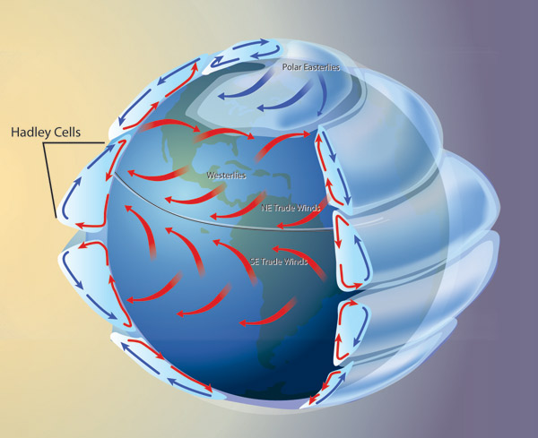
Figure 2: Hadley cells and prevailing winds
Solar warming of the tropics drives atmospheric circulation in three cells. Rotation of the Earth generates Coriolis forces that create the easterly trade winds below 30° latitude and polar easterlies above 60° latitude. Coriolis forces create prevailing westerlies in the mid-latitudes.
© 2011 Nature Education All rights reserved.
The sinking air mass at 30˚ latitude drives two phenomena: It contributes to the formation of arid climates and drives circulation of air north and south of the tropics. Dry, even desert-like conditions often occur at 30˚ north and south latitude because the descending dry air draws moisture from the soil (Figure 3). As warm air rises in the tropics, cool air is drawn from surrounding areas to fill the void. This creates the trade winds that blow in subtropical regions. But some of the air that descends from the Hadley cell is drawn away from the equator toward the poles. This air mass creates winds that characterize weather patterns in the temperate zones.
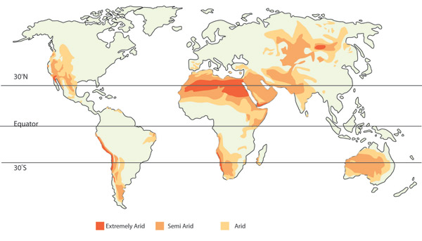
Figure 3: Distribution of arid land
Dry air descends at 30° latitude, drawing moisture from the soil and contributing to the creation of arid climates.
© 2011 Nature Education All rights reserved.
Under the influence of Earth's rotation, air returning to Earth's surface is deflected by the Coriolis force, which shifts the flow of air to the right of its initial trajectory in the northern hemisphere and to the left of its trajectory in the southern hemisphere. Winds blowing toward the equator are deflected to the west, creating the easterly trade winds (easterly winds blow from east to west). In the temperate zones, where the winds blow toward the poles, the Coriolis force deflects them toward the east, with prevailing westerlies (blowing from west to east) transporting most weather patterns in these temperate climes (Figure 2).
Ocean Currents
Earth's rotation affects the oceans in a similar manner, setting up currents that flow within the ocean basins. Ocean currents are driven by surface winds, Earth's rotation, and differences in salinity.
Trade winds blow warm surface waters in tropical oceans and seas from east to west. Warm water pools along the west coast of continents, which sets up a temperature gradient across the ocean surface. Under normal conditions, the western Pacific is about 8°C warmer than the eastern Pacific, and this gradient contributes to the formation of clouds and precipitation in Australia, Indonesia, and parts of Africa. Disruption of this temperature gradient creates the event known as El Niño.
Movement of water away from the coast of Peru and Ecuador creates an upwelling, as cold water is drawn from below to fill the space (Figure 4). Similar conditions occur on the west coast of continents in the Atlantic and Indian Oceans. These regions are the primary source of mixing between warmer surface waters and colder deep waters, which ordinarily remain separate. The upwelling of nutrient-rich water contributes to the unusually high biological productivity of the coastal waters in these regions.
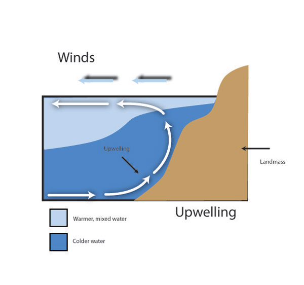
Figure 4: Upwelling
As the trade winds blow warm surface waters away from the west coast of continents, cold, nutrient-rich water is drawn to the surface.
© 2011 Nature Education All rights reserved.
Just as Earth's rotation creates the prevailing winds, it creates surface currents within the oceans. Under the influence of the trade winds, surface waters near the equator flow from east to west. As in the atmosphere, the Coriolis force causes water to be deflected away from the equator (northward in the Northern Hemisphere, southward in the Southern Hemisphere). This Coriolis Effect sets up a rotational convection within the oceans, and currents typically flow in a clockwise rotation in the Northern Hemisphere and in a counter-clockwise direction in the Southern Hemisphere. As it reaches the poles, the water cools and sinks. Prevailing winds in northern and southern latitudes help to create cold-water surface currents that flow back toward the equator along the west coast of continents.
Surface waters freeze as they reach the arctic waters of the North Atlantic. The freezing process removes water molecules, but not salt, from the ocean. The result is an increase in the salinity of ocean waters. With increased salinity and decreased temperature comes greater density — water is densest at 4°C — and the water sinks to the ocean floor. This process sets up a large, slow, deep-water "conveyor belt" that transports water along the ocean floor to Antarctica then through the Indian, Pacific, and eventually Atlantic oceans.
Global Climate
The combination of oceanic and atmospheric circulation drives global climate by redistributing heat and moisture. Areas located near the tropics remain warm and relatively wet throughout the year. In temperate regions, variation in solar input drives seasonal changes. In the Northern Hemisphere where land masses are more concentrated, these seasons can involve pronounced changes in temperature. In the Southern Hemisphere where large land masses are located nearer to the equator and the majority of Earth's surface is covered with water, seasonal cycles revolve around the presence and absence of precipitation rather than major swings in temperature.
Global climate patterns are dynamic: They are continually changing in response to solar radiation, atmospheric greenhouse gas concentrations, and other climate forcing factors. Among the more predictable of these changes are cyclical changes in solar radiation reaching the poles. These cycles, first described by Milutin Milankovitch (1941), involve Earth's orbit, tilt, and the precession of the equinoxes.
Earth's elliptical orbit around the sun shifts under the gravitational pull of other planets in our solar system. In a 100,000-year cycle, the orbit shifts from one that is nearly circular to one that is elongated, pulling the planet further from its energy source (Figure 5A). Earth's tilt relative to its orbit changes in a 41,000-year cycle from 21.5° to 24.5°; we are currently in the middle of this cycle with a tilt of 23.5° (Figure 5B). Finally, the axis (north-south orientation) of the Earth wobbles over time. This 23,000-year precession of the equinoxes changes the orientation of the planet relative to its location in orbit (Figure 5C). When all three Milankovitch cycles reinforce each other, they alter solar input and influence oceanic and atmospheric circulation patterns. This can lead to regular periods of cooling and glaciation.
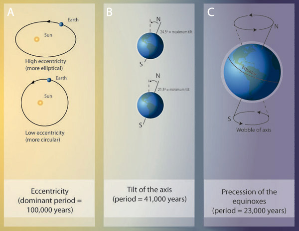
Figure 5: Milankovitch cycles
(A) High eccentricity in Earth's orbit takes it further away from the sun. (B) The degree of Earth's tilt relative to its plane of orbit changes the degree of warming in the polar regions. (C) Precession of the equinoxes occurs as Earth wobbles on its axis. All three cycles can influence warming and cooling periods by altering the amount of solar radiation that reaches Earth.
© 2011 Nature Education All rights reserved.
Periods of cooling can be intensified through albedo; the presence of snow and ice reflects incident sunlight and heat, which serves to further cool the planet. In this way, glaciers and polar ice caps continue to grow during periods when incident sunlight is low. As more water becomes locked up as ice, the surface level of oceans drops, which can alter oceanic circulation patterns. In addition, movement of continental land masses through the processes of plate tectonics can shift the flow of water, altering ocean currents and circulation patterns.
As Earth's precession and tilt increase polar exposure to sunlight, rapid melting events can occur. Freed from the grip of ice, soils thaw and previously frozen vegetation decays, releasing both carbon dioxide and methane gas — two noted greenhouse gases — into the atmosphere. Increases in carbon dioxide and methane in the atmosphere help to further warm the earth, and these gases are thought to have contributed to historical rapid warming events.
Biogeography
The current distribution of plants and animals reflects historical changes in both global climatic conditions and the location of land masses. During cold periods, when much of the land was covered in snow and ice, the amount of land available for terrestrial organisms to inhabit decreased, increasing competition for resources. As the ice retreated during warming events, organisms migrated to fill newly-available areas, and many species flourished under the new environmental conditions. Over time, organisms evolved adaptations that better enabled them to exploit their new surroundings. Some of those adaptations persist in their modern-day descendants.
While climatic conditions were changing, so were the locations of large land masses as they shifted under the influence of magma currents beneath the crust. Continental collisions built mountain ranges and widening rifts became seas, both of which served to create barriers to organismal dispersal, restricting the ability of organisms to migrate. Restricted to smaller areas, organisms evolved traits that best suited them to the environmental conditions of their continent and region.
Today we recognize six biogeographic realms — Nearctic, Palearctic, Neotropical, Ethiopian, Oriental, and Australian — in which animals exhibit features distinctive to that region (Figure 6). Realms that have experienced barriers to dispersal for longer periods of time contain animals with more distinctive traits. One of the best examples of this can be seen in the marsupial mammals of the Australian Region, which has a long history of isolation from other continents.
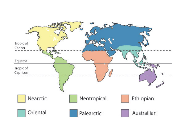
Figure 6: Biogeographic realms
Variation in climate and presence of barriers to dispersal has led to six major realms of organisms. The realms are not clearly delineated, rather species mix along boundaries.
© 2011 Nature Education All rights reserved.
References and Recommended Reading
Broecker, W. The great ocean conveyor. Oceanography 4, 79–89 (1991).
Brown, J. H. & Lomolino, M. V. Biogeography, 2nd ed. Sunderland, MA: Sinauer Associates, 1998.
Campbell, N. A. et al. Biology, 7th ed. San Fransisco CA: Pearson, 2005.
Ekman, V. W. On the influence of the Earth's rotation on ocean currents. Arckiv för Matematik, Astronomi och Fysik 2, 1–52 (1905).
Gross, M. G. Oceanography: A View of Earth. Englewood Cliffs, NJ: Prentice Hall, 1993)
Holton, J. R. An Introduction to Dynamical Meteorology, 4th ed. Burlington, MA: Elsevier Academic Press, 2004.
Lutgens, F. K. et al. The Atmosphere: An Introduction to Meterorology, 8th ed. Englewood Cliffs, NJ: Prentice Hall, 2001.
Milankovitch, Milutin. Canon of Insolation and the Ice Age Problem. Belgrade: Zavod za Udz̆benike i Nastavna Sredstva. 1941.
National Oceanic and Atmospheric Administration. NOAA Tropical Atmosphere Ocean Project.
Pidwirny, M. "Surface and Subsurface Ocean Currents." In Fundamentals of Physical Geography, 2nd ed. (2006).
Ruddiman, W. F. Earth's Climate: Past and Future, 2nd ed. New York, NY: W. H. Freeman and Company, 2008.
Stowe, K. S. Ocean Science. New York, NY: John Wiley & Sons, 1979.
Trefil, J. & Hazen, R. M. The Sciences: An Integrated Approach, 4th ed. New York, NY: John Wiley & Sons, 2004.