


« Prev Next »
Coastal Processes
The coastal zone is that part of the land surface influenced by marine processes. It extends from the landward limit of tides, waves, and wind blown coastal dunes, and seaward to the point at which waves interact significantly with the seabed.The coastal zone is a dynamic part of the Earth's surface where both marine and atmospheric processes produce rocky coasts, as well as beaches and dunes, barriers and tidal inlets, and shape deltas. The atmospheric processes include temperature, precipitation, and winds, while the major marine processes are waves and tides, together with water temperature and salinity. The coast also supports rich ecosystems, including salt marshes, mangroves, seagrass, and coral reefs. The diverse coastal ecology is favored by the shallow waters, abundant sunlight, terrestrial and marine nutrients, tidal and wave flushing, and a range of habitat types.
Waves — generation and types.
Waves provide about half the energy to do work at the coast. Ocean waves are generated by wind blowing over the ocean surface. The stronger the wind, the longer it blows and the longer the fetch, or stretch of ocean over which it blows, the larger the waves (Figure 1). The world's greatest wave factories are in the zone of sub-polar lows centered on 40–60° N and S latitudes, the so-called roaring 40's and screaming 60's. The strong westerly winds produce the world's biggest waves which initially head west, and are deflected equatorward by the Coriolis effect, arriving from the northwest in the northern hemisphere and southwest in the southern hemisphere (Figure 2). Other major wave climates are the easterly waves produced by the expansive but moderate velocity northeast and southeast Trade winds — and lesser seasonal waves produced by the monsoons and even the polar easterlies, together with occasional hurricanes that can produce massive waves as well as storm surges.
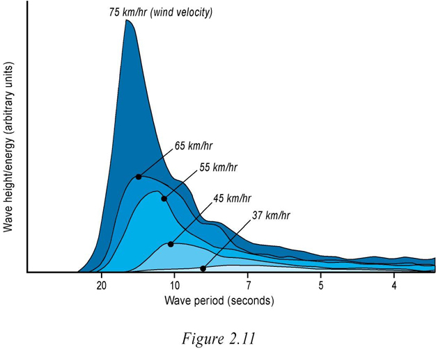
Figure 1
As wind velocity increases, the period or time between waves, and wave length, increases, and the amount of energy transferred to the waves increases exponentially. Note how as wind velocity doubles from 37 to 75 km/hr the amount of energy increases exponentially. Very strong winds are therefore required to generate the biggest waves.
© 2012 Nature Education All rights reserved. 
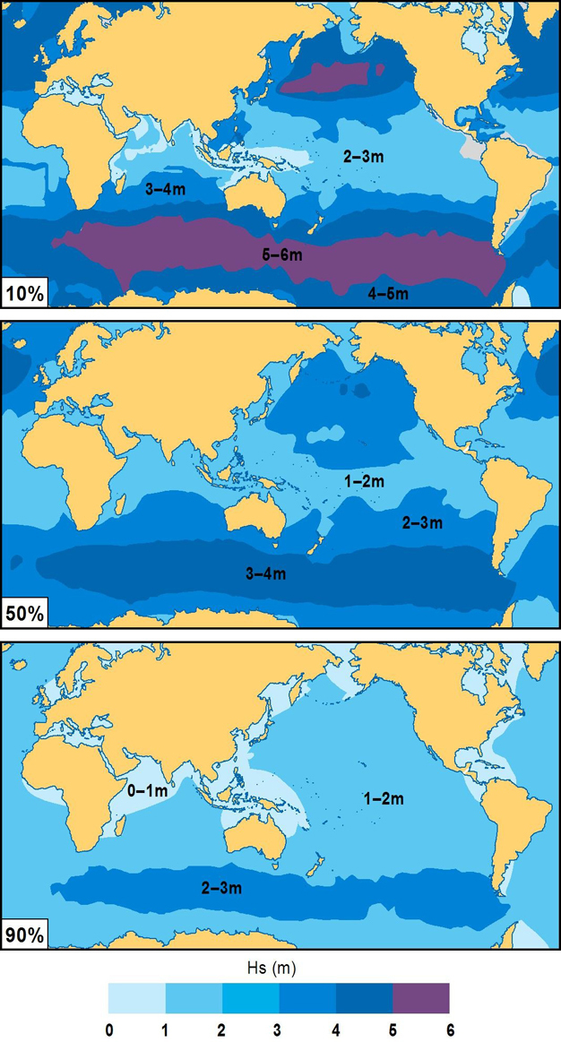
Figure 2
The highest waves occur in the Southern Ocean and north Pacific and Atlantic where they are generated by strong sub-polar lows. They average 5–6 m in height 10% of the year (top). The Southern Ocean has the most persistent higher waves averaging 3–4 m 50% of the time (centre), and at least 2–3 m 90% of the year (bottom). While the sub-tropical trade winds also blow year round across huge sections of ocean, they are of only moderate velocity, and hence generate only moderate waves.
© 2012 Nature Education Reprinted with permission from Short & Woodroffe 2009. All rights reserved.
When waves are being generated they are called a sea and consist of short, steep, high, slower waves, which tend to topple over and break, and have a broad spectrum of direction. Once the wind stops blowing, and/or the waves leave the area of generation, they quickly transform into swell — lower, longer, faster and uniform in direction. Swell waves can theoretically travel around the world with minimal loss of energy, while in reality they eventually break on some distant shore.
Waves are a form of potential energy that can be transported across hundreds to thousands of kilometers of ocean to be released as kinetic energy when they shoal and break. Waves are defined by their height (H) (trough to crest), length (L) (crest to crest) and period (T) (time between successive crests). The longer the period the longer and faster the waves, as wave length L=1.56 T, and wave velocity C = 1.56 T2. When waves enter shallow water their velocity is controlled by the water depth (d) such that C=√gd where g is the gravitational constant. For this reason waves slow down as they move towards the shore, with a 10 sec wave traveling at 56 km/hr (35 mph) in deep water slowed to 7 km/hr (4 mph) in 5 m water depth.
Tides and tidal currents.
Tides are produced by the gravitational pull of the Moon and Sun acting on a rotating Earth. This pull produces a very slight bulge in the ocean, which we know as tide. The tides and the currents they generate are responsible for about 50% of the marine energy delivered to the coast. The major impact of tides is to shift the shoreline between high and low tide, and to generate tidal currents either parallel to the coast, or at tidal inlets and estuaries, currents flowing into the inlets and perpendicular to the coast (Figure 3).
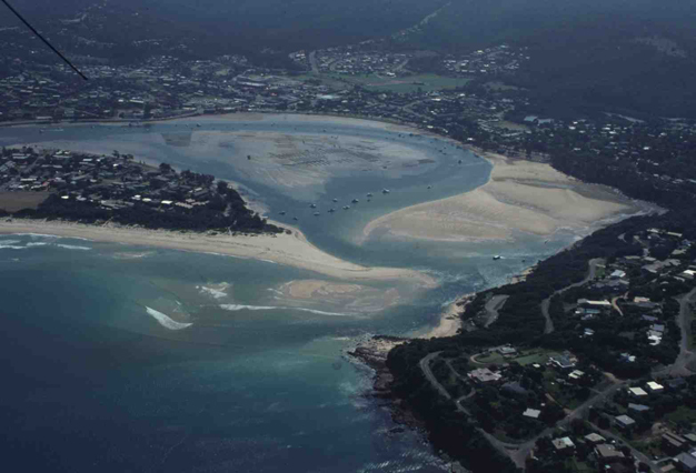
Figure 3
Tidal inlet at Merrimbula, Australia. Tidal currents ebb and flood though the narrow inlet moving marine sand from the beach into the inlet to form a deep tidal channel and shallow sandy tidal delta.
© 2012 Nature Education Courtesy of A. D. Short. All rights reserved.
Wind and currents.
Winds blowing over the oceans are responsible for generating ocean waves. Nearer the coast they can generate local seas — they can move the ocean surface and generate locally wind driven currents which in places can result in upwelling and downwelling. Finally, when blowing over the beach, they can transport sand inland to build coastal sand dunes.
Fluvial-deltaic systems.
Fluvial systems deliver sediment to the coast where it is deposited in estuaries and deltas. Depending on their location, deltas are also acted on by waves, tides, and other currents, and shaped to suit the prevailing processes. Sediment can also be moved longshore to supply beach and barrier systems (Figure 4).
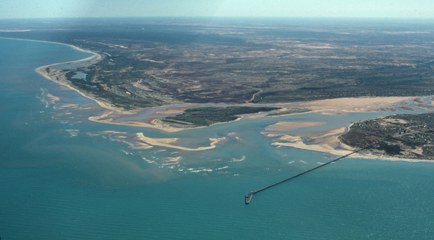
Figure 4
The Gasgoyne River delta in Western Australia delivers large volumes of sand to the coast where it is deposited in river mouth shoals and slowly reworked longshore to supply downdrift spits, barriers, and dunes.
© 2012 Nature Education Courtesy of A. D. Short. All rights reserved.
Sea level.
Sea level determines the position of the shoreline. During the last glacial maxima (ice age) 18,000 years ago, sea level was 120 m below present, and the continental shelves were exposed. It then rose, reaching present sea level around 6,000 years ago, after which it was relatively stable. Now, with climate change, it is beginning to rise again, and may rise as much as 1 m over the next 100 years, triggering shoreline retreat, inundation, and erosion.
Beach Systems
What is a beach?
Beaches are wave-deposited accumulations of sediment located at the shoreline. They require a base to reside on, usually the bedrock geology, waves to shape them, sediment to form them, and most are also affected by tides. The beach extends from wave base where waves begin to feel bottom and shoal, across the nearshore zone, though the surf zone to the upper limit of wave swash (Figure 5). In the coastal zone ocean waves are transformed by shoaling, breaking, and swash. In doing so they interact with the seabed, and determine the beach morphology or shape, a process called beach morphodynamics.
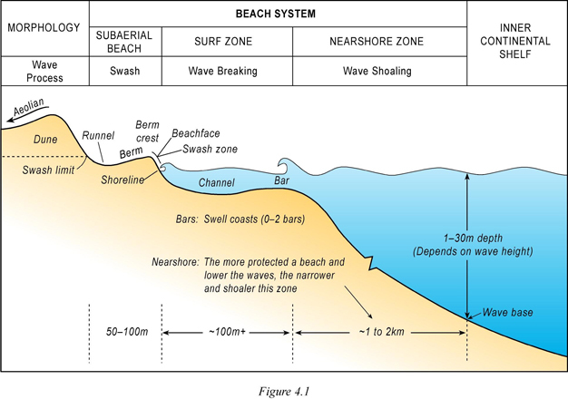
Figure 5
An idealised cross-section of a wave-dominated beach system consisting of the swash zone which contains the subaerial or 'dry' beach (runnel, berm, and beach face) and is dominated by swash processes; the energetic surf zone (bars and channels) with its breaking waves and surf zone currents; and the nearshore zone extending out to wave base where waves shoal building a concave upward slope.
© 2012 Nature Education Reprinted with permission from Short & Woodroffe 2009. All rights reserved.
Beach sediment — types & sources.
All beaches consist of sediment, which can range in size from sand up to cobbles and boulders. The finer sand result in very low gradient (~1°) beaches while cobbles may be stacked as steep as 20° (Figures 6a and 6b). Most beaches with fine to medium sand have a swash zone gradient between 1–8°.
In the mid latitudes most beaches are composed of siliceous or quartz sand grains derived from erosion. In the topics, coral reef detritus and shells known as 'carbonate sediment' tend to dominate, (Figures 6c and 6d), while in higher latitudes physical weathering produces coarse rock fragments and gravel.
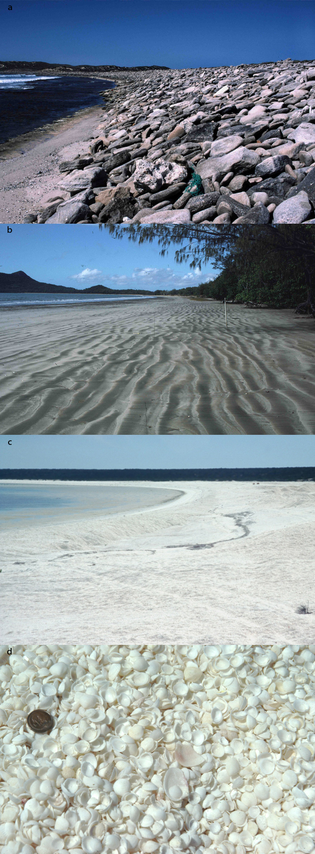
Figure 6
a) A steep cobble-boulder beach at Catfish Bay, Western Australia. (b) Low-gradient fine sand beach at Ball Bay, Queensland. (c) Shell Beach, Western Australia is composed entirely of the white cockle shell Fragum erugatum. (d) Close up view of the cockle shell.
© 2012 Nature Education Courtesy of A. D. Short. All rights reserved.
Sediments may therefore be derived from the land and delivered via rivers, glaciers and shoreline erosion, and from marine organisms in the sea. Once at the shore they are moved onshore by wave, tide, and wind driven currents to form beaches. A positive sediment supply produces beach accretion while when negative beaches erode (Figure 7).

Figure 7
a) Greenmount Beach in Queensland, Australia widened by 200 m as a result of beach nourishment. b) Collaroy Beach in NSW, Australia has been eroding, resulting in the construction of rock seawalls.
© 2012 Nature Education Courtesy of A. D. Short. All rights reserved.
Beach sub-systems.
At the beach the three zones of wave transformation (shoaling, breaking, and swash) produce three morphologically distinct sub-systems (Figure 5). The shoaling wave zone builds a low gradient (~1°) concave upward profile, smooth in outline, with small wave-generated ripples and generally onshore sediment movement. As they shoal they interact with the seabed, slowing down and increasing in steepness and height (Figure 8).
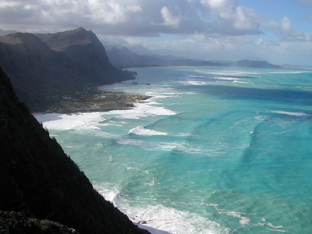
Figure 8
View of Makapu Beach, Hawaii, showing waves shoaling and steepening as they travel across and interact with the nearshore zone, then breaking across the surf zone.
© 2012 Nature Education Courtesy of A. D. Short. All rights reserved.
The surf zone is the most dynamic part of the beach and extends from the breaker zone to the shore. Waves break when the water depth is approximately 1.5 times the wave height. They can break as a spilling breaker on low gradient slopes, a plunging wave on moderate gradients, or a surging wave on steep slopes. In breaking, waves transform their potential energy to kinetic energy, which is initially manifest as the broken wave of translation, or wave bore, which moves shoreward as broken white water. At the shoreline the currents can be deflected longshore and water may return seaward as a rip current.
Surf zone currents can transport sediment onshore, longshore and offshore and build the (sand) bars and troughs that occupy the surf zone (Figure 5). The number and location of the bars is a product of infragravity waves, a low frequency (greater 30 sec period) wave produced by sets of higher and lower waves and which is enhanced by wave breaking across the surf zone. The longer the infragravity wave period the more widely spaced the bar(s). Another form of infragravity wave called edge waves also influence the longshore spacing of rip currents and channels, which are typically 200–300 m apart on ocean beaches. Rip currents are narrow, seaward moving currents that move seaward though the surf zone, often in a deeper rip channel (Figure 9a). They are a mechanism for returning the water back out to sea, and a conduit to transport seaward eroded beach sediment (Figure 9b) during high seas. They are also a major hazard to beach goers and responsible for most beach rescues and drowning (Short 1999).
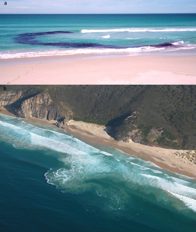
Figure 9
a) Low waves breaking on a shallow bar and flowing shoreward into a rip feeder channel. The dye highlights the rip feeder current flowing along the base of the beach face, then turning to flow seaward in the deeper rip channel. b) A rip current (center) carrying suspended sediment flowing out beyond the surf zone as a rip head, with an earlier rip head meandering to the right, Miles Beach, Tasmania.
© 2012 Nature Education Courtesy of A. D. Short. All rights reserved.
When the broken wave reaches the base of the wet beach it collapses and runs up the beach face as swash or uprush in the swash zone (Figure 10). The uprush stops toward the top of the slope, some percolates into the beach, the remainder flows back down the beach as backwash. Both actions produce a relatively steep seaward sloping swash zone or beach face, which can range from 1 to 20°. As sediment is deposited in the swash zone it can build a berm, a near horizontal to slightly landward-dipping sand surface, the area where most people sit when they go to the beach. The swash zone may also contain beach cusps, spaced about every 20 to 30 m and produced by another form of edge wave (Figure 11).

Figure 10
Wave runup on the steep beach face at Ke lli Beach, Hawaii.
© 2012 Nature Education Courtesy of A. D. Short. All rights reserved.
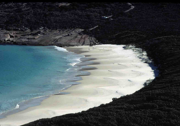
Figure 11
A steep reflective beach with well developed high tide beach cusps at Hammer Head, Western Australia.
© 2012 Nature Education Courtesy of A. D. Short. All rights reserved.
Beach types.
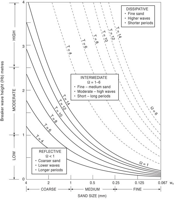
Beaches can range from low energy systems, where small waves lap against the shore, to those with high waves breaking across several hundred meters of surf zone. They can also be exposed to micro (<2 m), meso (2–4 m), macro (4–8 m) and mega tides (>8 m). To accommodate the range of wave heights, tide ranges and beach sediment (sand to boulders) beaches are divided into the three basic types: wave-dominated, tide-modified, and tide-dominated, based on the relative tide range (RTR) (Short 2006, see also http://www.ozcoasts.org.au/conceptual_mods/index.jsp).

| RTR = TR/H |
where TR is the spring tide range.
Wave-dominated beaches have an RTR tide range less than three times the average wave height (RTR < 3). They consist of three states — reflective, intermediate, and dissipative. Reflective beaches are produced by lower waves (H<0.5 m), longer wave periods, and coarser sediment, such that all coarse sand and cobble/boulder beaches are reflective (Figure 12). They consist of a relatively steep beach face (5–20°), with waves breaking by surging at the base of the beach and running up the beach face and returning as backwash to ‘reflect' off the beach face. There is no bar or surf zone (Figure 11).
Figure 12
A plot of breaker wave height versus sand size, together with wave period, that can be used to determine the approximate beach state for wave-dominated beaches. To use the chart, determine the breaker wave height, period and grain size (mm). Read off the wave height and sand size, then use the period to determine where the boundary of reflective/intermediate, or intermediate/dissipative beaches lies. Ω = 1 along solid T lines and 6 along dashed T lines. Below the solid lines Ω < 1 and the beach is reflective; above the dashed lines Ω > 6 and the beach is dissipative; between the solid and dashed lines Ω is between 1 and 6 and the beach is intermediate. (Ω=Hb/WsT and is known as the dimensionless fall velocity).
© 2012 Nature Education Reprinted with permission from Short 1999. All rights reserved.
Intermediate beaches are common on open coasts and require moderate waves (H=0.5–2.5 m) and fine to medium sand. They are characterized by a surf zone with one or two bars up to 100 m wide. The bar is usually cut by regular rip channels and currents (Figure 13).
Figure 13
Well-developed intermediate beach containing transverse bars and rip channels along Lighthouse Beach, Australia. Note the waves breaking on the bars, with no waves breaking in the deeper darker rip channels. Also note the rhythmic shoreline protruding in lee of the bars and forming an embayment in lee of the rips.
© 2012 Nature Education Courtesy of A. D. Short. All rights reserved.
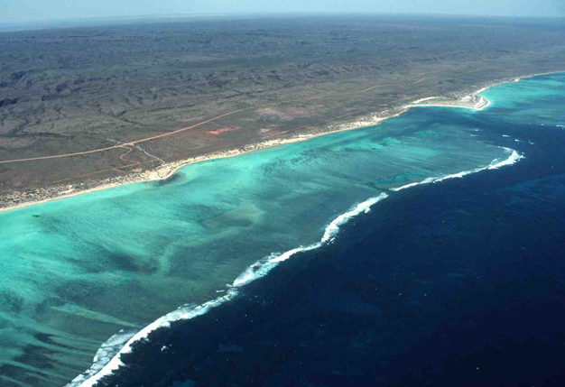
Dissipative beaches require both high waves (H>2.5 m) and fine sand. They have a low gradient swash (~1°) and 300–500 m wide surf zone containing at least two bars. Waves break on the outer then inner bar(s), thereby dissipating their energy as the move across the surf zone (Figure 14).
Figure 14
Long, high Southern Ocean swell arriving at Dog Fence Beach, South Australia. The swell breaks over the wide outer bar, reforms in the central trough, then breaks across the inner bar, resulting up to 10 lines of breakers and a 500 m wide dissipative beach and surf zone.
© 2012 Nature Education Courtesy of A. D. Short. All rights reserved.
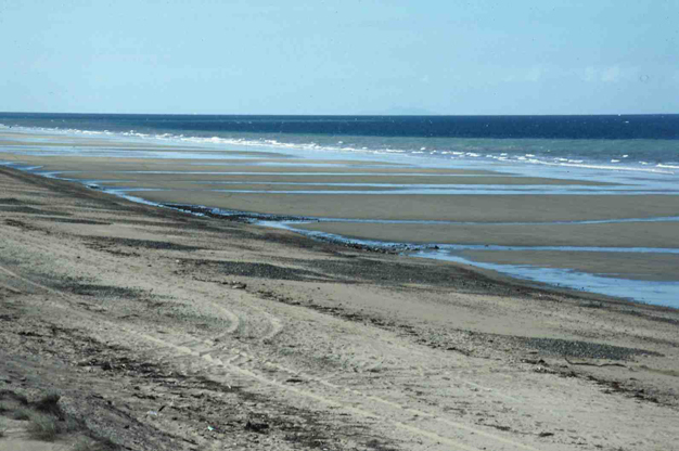
Tide-modified beaches have an RTR between 3 and 10, implying tide range is increasing and/or wave height decreasing. They usually have a steep, coarser-grained, cusped, reflective, high tide beach. This is fronted by a wide, finer-grained, low gradient, often featureless, intertidal zone, up to 200 m wide, then a low tide surf zone which may contain bars and rip channels (Figure 15).
Figure 15
A steep reflective high tide beach face fronted by a 100 m wide tide-modified low tide terrace crossed by shallow drainage channels at North Harbour Beach, Australia.
© 2012 Nature Education Courtesy of A. D. Short. All rights reserved.
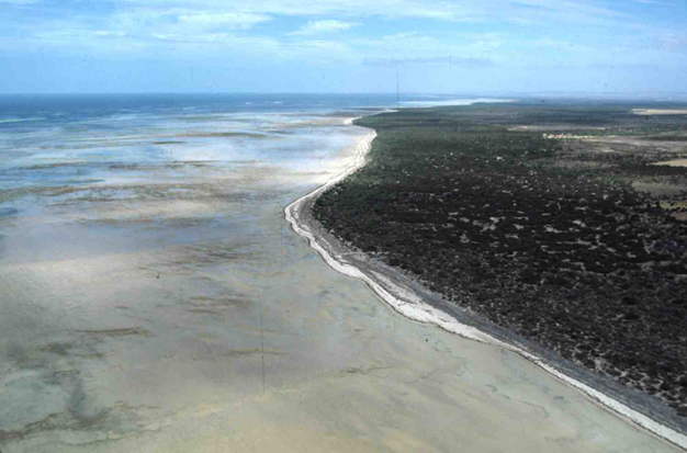
Tide-dominated beaches have an RTR between 10 and approximately 50, implying high tides and/or very low waves (H<<0.3 m). They consist of a low elevation, coarse-grained, irregular, high tide beach, fronted by low gradient (<<1°) inter-tidal sand, and even mud flats that may be hundreds of meters wide (Figure 16). Beyond an RTR of 50, tidal flats prevail.
Figure 16
A narrow high tide beach fronted by 1 km wide inter-tidal sand flats, upper Spencer Gulf, South Australia.
© 2012 Nature Education Courtesy of A. D. Short. All rights reserved.
An additional beach type consists of a high tide reflective beach face fronted by intertidal rocks flats, and in the tropics a high tide beach fronted by a fringing coral reef flat (Figure 17). Furthermore any beach located in the high latitudes will be seasonally exposed to freezing air and water temperatures leading to the development of sea ice, shoreface ice, and a frozen snow covered beach (Figure 18).
Figure 17
A high tide beach fringed by coral reef at Turquoise Bay, Western Australia, part of the Ningaloo Marine Park.
© 2012 Nature Education Courtesy of A. D. Short. All rights reserved.
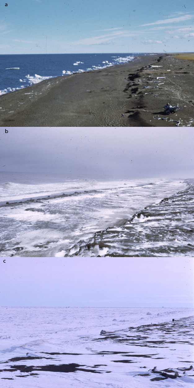
Figure 18
The beach at Pingok Island, north Alaska, shown a) during summer, with floating ice against the shore; b) during freeze-up, with snow and sea ice accumulating; and c) the frozen winter beach and ocean.
© 2012 Nature Education Courtesy of A. D. Short. All rights reserved.
Beaches and barriers.
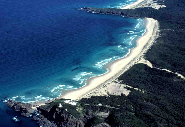
Beach systems are an essential component of a larger scale coastal landform called barriers, which are long-term accumulation of wave, tide, and wind deposited marine sediment (usually sand) at the shore. They consist of a beach from which sand is transported either onshore, via wave overwash and/or wind blown sand, or alongshore, to form spits and move into tidal inlets (Figure 3). When separated from the mainland by lagoons and marshes (Figure 19) they are called barrier islands (Figure 20), which occur along the US East and Gulf coasts. Some are backed by large dune systems as along the Oregon coast.

Figure 19
A coastal sand barrier consisting of a beach and vegetated dunes, backed by a lagoon, at Big Beach, Queensland, Australia.
© 2012 Nature Education Courtesy of A. D. Short. All rights reserved.
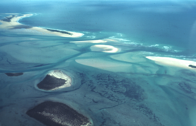
Figure 20
A series of low barrier islands separated by tidal inlets, at Corner Inlet, Victoria, Australia.
© 2012 Nature Education Courtesy of A. D. Short. All rights reserved.
References and Recommended Reading
Davidson-Arnott, R. A. Introduction to Coastal Processes and Geomorphology. Cambridge, UK: Cambridge University Press, 2009.
Davis, R. A., Jr. "Beach and nearshore zone," in Coastal Sedimentary Environments, ed. R. A. Davis, Jr. (New York, NY: Springer-Verlag, 1985) 379–444.
Komar, P. D. Beach Processes and Sedimentation, 2nd ed. Upper Saddle River, NJ: Prentice Hall, 1998.
Masselink, G., Hughes, M. G. & Knight, J. Introduction to Coastal Processes and Geomorphology. 2nd edition, London, UK: Hodder Education, 2011.
Short, A. D. ed. Handbook of Beach and Shoreface Morphodynamics. Chichester, UK: John Wiley and Sons, 1999.
Short, A. D. Australian beach systems — Nature and distribution. Journal of Coastal Research 22, 11–27 (2006).
Short, A. D. & Woodroffe, C. D. The Coast of Australia. Melbourne, Australia: Cambridge University Press, 2009.
Woodroffe, C. D. Coasts — Form and processes. Cambridge, UK: Cambridge University Press, 2002.