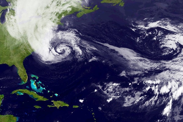
Many early forecasts for Hurricane Sandy last year predicted that the system would fizzle over the Atlantic. Yet a model developed by researchers at the European Center for Medium-Range Forecasts showed a more alarming scenario: the storm would instead turn west to threaten the Eastern Seaboard. The model's refined predictions pinpointed the hurricane's landfall around the New Jersey area in time to allow residents to seek higher ground. The key to the more accurate forecast involved mathematical mastery of the storm's chaotic behavior.
Weather forecasts are calculated with computers that solve equations involving variables such as wind speed, pressure, temperature, air density and humidity. If the earth somehow possessed just one weather system, our fist shaking at forecasts could end. Instead, of course, the planet harbors many systems that intermix across boundaries and scales, making forecasting a tangled problem.
In the case of Sandy, forecasters monitored a higher-order variable called potential vorticity, a measure of a weather system's swirl, to help predict the storm's future development. A crucial ingredient for Sandy's devastating landfall proved to be an enhancement of this swirl measure caused by a trough of low-pressure air that was thousands of miles away in the northeastern Pacific when the tropical depression first formed. As Sandy moved north from the Caribbean, the distant trough traveled east across the U.S. on what turned out to be a collision course. On October 29 Sandy's warm, moist air began to rise as it approached the trough's cooler air, whipping up stronger winds. As the two weather systems coiled around each other, Sandy surged in strength and curved toward the nation's northeastern shoreline, just as the European researchers had foreseen. The ultimate accuracy of the group's forecasts about a week before Sandy's landfall can be attributed to the success of its model in predicting and capturing the interaction between these weather systems.
On supporting science journalism
If you're enjoying this article, consider supporting our award-winning journalism by subscribing. By purchasing a subscription you are helping to ensure the future of impactful stories about the discoveries and ideas shaping our world today.
The step-by-step quantification of this stormy choreography was accomplished solely through the careful application of mathematics. By predicting Sandy's landfall, in a very real sense, the European team's math helped to save American lives.