Volume 15
-
No. 12 December 2022
Urbanized landslidesA large, slow-moving landslide underlying the city of Kivu in the Democratic Republic of the Congo has accelerated in recent decades due to hydrological modifications related to urbanization, according to an analysis of aerial photographs and remote sensing data. The drone orthomosaic image shows the head of the Funu landslide in the densely inhabited city of Bukavu, eastern Democratic Republic of the Congo, in October 2017.
See Dille et al.
-
No. 11 November 2022
Deep water uncoveredHydrous conditions extend across the 660 km discontinuity between Earth’s mantle transition zone and lower mantle, according to analysis of a polyphase mineral inclusion in a gem-type diamond from the Karowe mine, Botswana. The image shows a super-deep diamond under crossed polarizers displaying strong dislocations around its mineral inclusions.
See Gu et al.
-
No. 10 October 2022
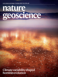
Climate variability shaped hominin evolutionFlamingoes over the 1–2 m shallow Lake Logipi, a remnant of a 300-m deep paleolake in the Suguta Valley, Kenya. Like the nearby Chew Bahir basin, the Suguta Valley is situated in the heart of the East African Rift System, one of the habitats of early human populations. This region, however, has repeatedly experienced dramatic habitat transformation during the Pleistocene–Holocene, associated with intense climatic variability as the 620,000-year environmental proxy record from nearby paleolake Chew Bahir shows.
See Foerster
-
No. 9 September 2022
Interplay between plants and rocksA statistical assessment of zircon compositions suggests that colonization of continents by plants approximately 430 million years ago enhanced the complexity of weathering and sedimentary systems and altered the composition of continental crust. Deep Earth archives thus record the greening of the continents. Ferns (pictured) were some of the first vascular plants to colonize the continents.
See Spencer
-
No. 8 August 2022
Barrier islands in retreatCoastal evolution simulations suggest that the modern retreat of coastal barrier islands is controlled by cumulative sea-level rise over the past several centuries and will accelerate by 50% within a century, even if sea-level rise remains at present rates. The image shows one of the Virginia Barrier Islands, Parramore Island, located off the west coast of the United States.
See Mariotti and Hein
-
No. 7 July 2022
Vulnerable mountain infrastructureClimate change is exacerbating geohazards in High Mountain Asia that pose a growing risk to hydropower and water infrastructure across the region. Improved monitoring and forecasting of cascading hazards and sustainable sediment management solutions are needed to inform climate change-resilient hydropower. The image shows an expanding moraine-dammed glacial lake in the Himalaya.
See Li et al.
-
No. 6 June 2022
Bennu’s active surfaceThe OSIRIS REx spacecraft’s observations of the rubble-pile asteroid Bennu reveal a weak and active surface undergoing rapid evolution. Bennu’s rugged geology — as imaged by the MapCam instrument onboard the spacecraft on 16 December 2018 — shows a surface littered with boulders, which cast long shadows owing to the high phase angle. Near the horizon, two large bowl-shaped craters can be seen: Ohnivak (~40 m diameter) and Alicanto (~60 m diameter).
see Bierhaus et al. , Perry et al. , Delbo et al. and News & Views by Arakawa
-
No. 5 May 2022
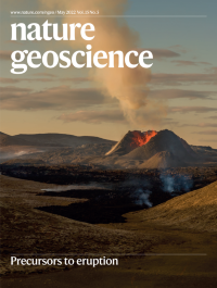
Precursors to eruptionIngression of magmatic gas into a geothermal aquifer generated cyclical deformation and primed the system for the 2021 Fagradalsfjall eruption, Iceland, according to a catalogue of 39,500 precursory earthquakes combined with a poroelastic model. The image, taken on the sunny evening of May 8th 2021, shows new black lava covering the bottom of the Geldingadalur valley releasing sulfury gasses while the crater emits volcanic gasses to the atmosphere.
See Flóvenz et al.
-
No. 4 April 2022
Oxidation by subducting metasedimentsMetasedimentary rocks atop the subducting slab oxidize ascending slab-derived dehydration fluids by removal of reduced species, according to petrological analysis of subduction complex metasedimentary rocks and reactive transport modelling. The image of a polished rock sample from Crete, Greece, shows subducted metamorphosed bauxite preserving a relic pisolitic structure that formed during surficial oxidative weathering.
See Ague et al.
-
No. 3 March 2022
From dust to cloudsCirrus cloud formation in the northern hemisphere is primarily triggered by mineral dust, according to global-scale dust observations and a cirrus formation model. In the image dust aerosol reddens the sunrise as the DC-8 aircraft prepares to sample the remote atmosphere during the NASA Atmospheric Tomography mission.
See Froyd et al.
-
No. 2 February 2022
Legacies of agricultural nitrogenMitigation efforts to curb agricultural nitrogen have been largely unsuccessful, but managing previously overlooked nitrogen legacies of landscapes could improve water quality. The image shows a late-summer phytoplankton bloom swirling in the Baltic Sea between the Swedish islands of Öland and Gotland. Such blooms have intensified in the last few decades. The image was taken in August 2020 using the Operation Land Imager instrument on Landsat 8.
See Basu et al.
-
No. 1 January 2022
Tropical cyclones on the moveHurricanes and typhoons are tracking further poleward due to the effects of climate change, according to a synthesis of numerical modelling results, observations, and paleoclimate records. This image illustrates the multi-scalar complexity of tropical cyclone processes that are poorly resolved in modern climate models. Five days after this convective structure was imaged, it became the category-5 Typhoon Goni.
See Studholme et al.