
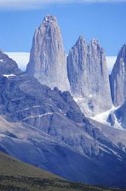
 These peaks are the result of an unusual plate tectonic crunch.Getty
A three-dimensional model of our planet's plate tectonics could help to explain why the Andes mountain range is taller than geologists would predict: it could all be down to the long length of the South American continent.
The highest mountain range on our planet — the Himalayas — was formed by the massive collision of two continental plates. But the Andes were formed where an oceanic plate slides beneath a continent. While this 'subduction' process is expected to create mountains through a crumpling of the continental plate above, it's perplexing why the peaks of the central Andes stand at an average height of 4 kilometres. Previous calculations based on models of plate tectonics have at times suggested they ought to be half that height.
To investigate, Wouter Schellart of the Australian National University in Canberra and colleagues created a computer model of the motion of Earth's tectonic plates over millions of years. They plugged in values for the strength and density of our planet's different plates, allowed gravity to pull the denser ones down, and watched what happened.
The team was particularly interested in what would happen to the shape of the boundary line between the subducting plate and the overriding one (called the subduction zone) — as seen from a bird's eye view.
When subduction zones are short from tip to tail they move relatively quickly, the team found, rapidly adopting a 'U' shape as seen from above. But longer boundaries — such as the subduction zone off the South American coast, which measures 7,400 kilometres from north to south — move more slowly and develop into a 'W' shape.
Sneaking round the edge
The boundary of a sinking plate is known to generally retreat backwards as more and more material slides underground. For example, the South American subduction zone, in which the subducting plate is moving eastwards, tries to move westwards over time. This leaves a gap on the side of the overriding plate that needs to be filled in with rock. The upper-mantle material beneath the subducting plate steps in to fill that gap, flowing around the edges of the sinking plate to get there.
When the length of the subduction zone is just a few hundred kilometres long, this flow of replacement rock is easy, the model shows. It simply nips around the edges, bending them as it does so. The result is a 'U'-shaped subduction zone.
But with long boundaries, it is too difficult for mantle rock from the middle of the subducting plate to travel all the way around that plate's edges to fill in a gap on the other side, the model finds. For South America, this means that the subduction zone bends at the northern and southern ends, as expected. But in the middle — near Bolivia — the boundary doesn't move much at all.
Make me a mountain
Because the overriding plate of South America is moving westward at some 2 centimetres per year, this causes a serious crunch at the middle of the subduction zone. Over the past 30 million years or so, says Schellart, 300-350 kilometres of continent has tried to move westward in this central part of the boundary but has found nowhere to go — nowhere but up.
Schellart says the same process is happening in mirror image on the other side of the Pacific, in the Japan subduction zone. But this collision has only been going on for less than 10 million years. "It's likely you'll get large mountain building there," he says. "It's in the initial stages."
Other theories have been advanced for why the Andes are unusually high. Researchers have suggested it is because there are no rivers to wash sediments into the trench between this subducting plate and the continent, creating an unlubricated zone with extra friction to prop up the mountains. But Schellart points out that there are other subduction zones without sediment, such as the one off Tonga, that don't form big mountains.
ADVERTISEMENT
"It's a good global model," says Seth Stein of Northwestern University in Evanston, Illinois, who has worked on the Andes. "The insight that smaller boundaries can change shape more quickly is very nice," he says. This even helps to explain why the 'boot' of Italy has swung round so dramatically — it pointed directly north to south some 15 million years ago, but the evolving shape of the short subduction zone there has pushed the boundary around counter-clockwise.
But Stein is doubtful that the model really answers all geologists' questions about the Andes. "The Andes are very much involved in the geology of the overriding continent, which isn't in their model," he says.
Visit our aretheandesso_tall.html">newsblog to read and post comments about this story.
-
References
- Schellart W. P., et al. Nature, 446 . 308 - 311 (2007). | Article |
