Rewilding the planet
An archipelago constructed of sand and mud is bringing new life to a dead lake but can this bold experiment have a lasting impact?

This article is also available as a pdf version.
Beyond the harbour walls of Lelystad in the Netherlands, dark waters stretch into the distance to meet overcast skies. On a cold winter day, there is little but the odd ship to interrupt the bleakness of Markermeer. Look carefully, however, and a smudge appears on the lake’s horizon. When the Sun shines on that distant spot, white sand glints in the light.
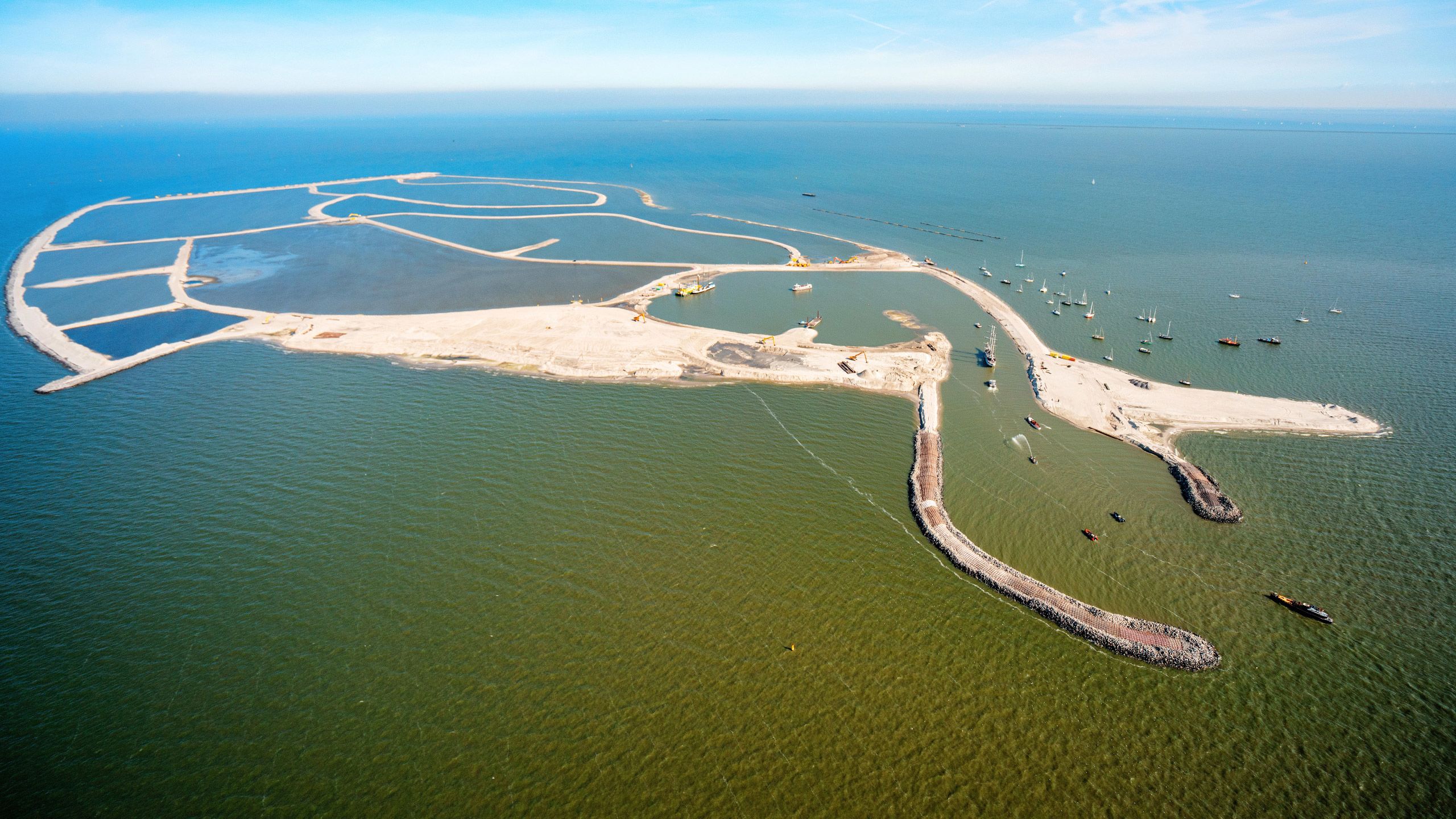
This is some of the newest land on the planet: Marker Wadden, a 1,300-hectare archipelago that ecological engineers, landscape architects and a dredging company have built since 2016. Taking sand and mud from the lake floor, they created seven islands enveloped by dunes and beaches. Now, a rich variety of plants, fish and insects have settled into that protected environment, along with vast numbers of breeding birds.
Marker Wadden is a paradox. Its lonely landscape feels like wild nature — yet it is carefully shaped by human hands. It has a marine character, with marram grasses waving on dunes and seashells scattered on the sandy paths — but it sits in a freshwater lake.
Marker Wadden is a 1,300-hectare archipelago in the Netherlands, built since 2016 almost entirely with material dredged from the lake floor of Markermeer.
Source: Natuurmonumenten
Scientists, too, find this island cluster hard to define. It was built to awaken a dead lake and will be one of the largest ecological restoration projects in western Europe if the long-term plan for the site is completed. Yet because the archipelago is newly built and unlike anything that was there before, some researchers say the term ‘restoration’ doesn’t fit. ‘Rewilding’ is another term applied sometimes to Marker Wadden, but some researchers say that a highly engineered space like this cannot be regarded as truly wild.
“Marker Wadden is fascinating because it presently doesn’t fit easy categories,” says Eric Higgs, a rewilding specialist at the University of Victoria in Canada.
“It’s like a simulacrum — it’s a copy of something that has no true original, because there was never ever a freshwater archipelago in that area,” he says.
Working out how to build and maintain Marker Wadden has proved controversial among scientists, engineers and nature lovers. Researchers say it will serve as a living laboratory for decades to come, and will provide lessons for restoration and rewilding projects elsewhere. That is, if nature doesn’t slowly wash the islands away.


A dead lake
The idea of building an island began to appeal to Roel Posthoorn — a tall, thin, quiet-spoken man who directs projects for the Dutch Society for Nature Conservation (Natuurmonumenten) — in around 2010.
He was concerned about the lake, which was once part of a long inlet of the North Sea that reached the outskirts of Amsterdam. Engineers had built a dyke across its mouth in 1932, creating a vast, 3,570-square-kilometre lake cut off from the ocean. In 1975, they sliced the lake roughly in half with a second dyke. The resulting inner lake, Markermeer, gradually turned from salt water to fresh. Because river input into the Markermeer is limited and its borders are hard without much vegetation, the lake became a dead zone. Just 3–4 metres deep, it is full of silt that gets stirred up by the wind, blocking light and slowing photosynthesis.
Posthoorn had previously tackled similarly damaged ecosystems, where barriers built to protect low-lying regions from the sea have also blocked tides and marine life. It is possible to mitigate these issues by making dyke breaches to allow tidal water to flush in and out, says Posthoorn, but he was convinced that human ingenuity, which had created the problem, could dream up new solutions.
“Nobody questions that we as human beings are able to mess up nature,” he says. “When you cannot go back to the past, you have to find new ways.”


Markermeer’s problems had been analysed for decades, costing around €45 million (US$49 million), says Posthoorn. Frustrated by the lack of progress, and building on various suggestions for solving the lake’s ecological problems, he quietly submitted his island idea to the Dutch Postcode Lottery — and, in 2012, won funding of €15 million.
There followed a rollercoaster year, during which Natuurmonumenten worked with the national government and regional ones to eventually raise a total of €90 million for the project. The executive agency of the ministry of infrastructure and water management (Rijkswaterstaat) and Natuurmonumenten commissioned the work. A Dutch dredging contractor, Boskalis in Papendrecht, worked with other companies to design the islands.
Aerial photos on the walls of the project’s site office on the Lelystad quayside reveal the drama of the islands’ emergence from the water. Posthoorn explains that the project went against the typical civil engineering approach of building hard defences against the forces of nature.
An early stage of the islands’ construction in September 2016. Credit: Robbert Frank Hagens/Alamy
An early stage of the islands’ construction in September 2016. Credit: Robbert Frank Hagens/Alamy
“They needed to make a design that offered a lot of room for natural dynamics and processes,” he says. “On the first day you will build it. But from the second day it’s in the hands of nature.”
Marker Wadden’s perimeter is, roughly, a rectangle, with one short and one long side providing an L-shaped, protective wall, built mostly of sand. One stretch — the 1.8 kilometres that is most exposed to the prevailing wind and waves — is made of stone.
The rest of the L shape takes the form of long and lonely white beaches with raised dunes behind them, providing protection for the seven low islands. Each of these consists of a sand ‘ring dyke’, or compartment, filled with mud. In all, it took 37.2 million tonnes of material dredged almost entirely from the lake floor. The first island was finished in 2016. A year later, a research programme began, carried out by a group of universities and research organizations, funded with about €6 million from a variety of sources. It is known as the Knowledge and Innovation Programme Marker Wadden (KIMA). Late last year, they presented their findings — but this is a young ecosystem, and their research has really only just begun (see go.nature.com/3mbz89t).
Built with mud
It takes around half an hour for the project’s boat to cross from Lelystad to Marker Wadden’s small marina, behind which are some austere wooden buildings, including a visitor centre and scientists’ dormitory. This is the human hub of the site, and the only island with tourist access.
High dunes flank one side of the settlement, and all that can be heard is the steady wash of waves, the tread of volunteers going about their tasks and birdsong. Paths radiate from the settlement along dykes, offering lonely vistas of pools, marshes and wildlife.
Posthoorn leads the way along one of these paths, flanked by beds of swaying reeds as high as people, which soon part to reveal mudflats covered mostly in a dark green plant known as marsh ragwort (Tephroseris palustris). It will put out yellow flowers in the spring “when the whole place will smell of honey”, says Posthoorn. Marsh ragwort is a pioneer plant — quick to take up residence on bare mud.


All of this mud was once metres below on the lake floor. The idea that dredged sediment could be put to good use has grown in recent years, and even has its own acronym — BUDS, or Beneficial Use of Dredged Sediment. In the United States, for example, the US Army Corps of Engineers, which annually dredges about 150 million cubic metres of sediment in the course of its work maintaining the nation’s shipping channels, last year set itself the goal of increasing beneficial use from 30% to 70% by 2030.
“Over the last 6–7 years, we’ve really seen the activity start to grow exponentially,” says Jeff King, a specialist in building with nature at the US Army Engineer Research and Development Center, who is based in Washington DC.
The US Army Corps has placed hundreds of small islands in bays and on coastlines where they offer protection, recreation and ecological refuges. Perhaps its biggest project has been shoring up the eroding Poplar Island in Chesapeake Bay, to which millions of tonnes of sediment have been added over the past 25 years. Elsewhere in the world, dredged sediment is used for engineering applications such as beach nourishment, coastal protection and land reclamation and, occasionally, for creating habitats, such as salt marshes or mudflats in estuaries and along coastlines. Marker Wadden, however, is not on the coast or in an estuary — it is in an inland lake. And, after an international survey, Natuurmonumenten concluded that there was no other project in the world on such a scale, apart from Poplar Island.
Mud is not easy to build with, as soon became apparent on Marker Wadden. For each island, the engineers gradually built up from the lake bottom a ring of sand, which they filled with muddy liquid. The clay, silt and peat in this liquid settled and some of its water evaporated, as expected. But this caused more contraction than anticipated, which meant more mud had to be added than was originally calculated. That process seems to have stopped now, but there is a new problem: the entire archipelago is sinking into the soft lake floor.
The islands of Marker Wadden were constructed in several stages mostly using material taken from the lake floor.
First, construction crews built small sandy walls about 1 to 1.5 metres high along the outer perimeter of each island.
Then they pumped in a mixture of mud and water to fill the interior.
Additional sand was added to the walls to raise them to the level of the lake surface.
The crew pumped in more of the mud–water mixture to fill the region between the sand walls.
Next, they raised the walls above the water level and created sub-compartments by adding additional sand walls.
The mud–water mixture was deposited to different levels in the compartments to create a variety of habitats.
Source: T. Vijverberg et al. Terra et Aqua 154, 30–40 (2019). (https://go.nature.com/4TVVHJU)
This is what Bart Schultz, a specialist in Dutch land and water management based in Delft , and who is unconnected to the project, predicted from the start. “If you throw sludge on sludge it will continue to sink,” he says, adding that “a total subsidence of about 2 metres may be expected over time”.
Thomas Vijverberg, who was engineering manager for the Marker Wadden project for the contractor Boskalis, says that the construction design process took into account how sediment deposited on the islands would settle, as well as the fact that their weight would compress the lake floor. Both of these contribute to the islands sinking, which is slowing down, he says.
What to do about that sinking is a matter of discussion. On a coast or in an estuary, a newly constructed island could grow by catching sediment washed in by tides and currents, says King. But in a freshwater lake, nature cannot help in this way. Instead, Posthoorn hopes that organic matter from plant decay will add height. Joep de Leeuw, a fisheries researcher at Wageningen Marine Research in IJmuiden, has studied the islands as part of the KIMA research collaboration. He points out that, although each island is protected from the surrounding lake by its ring dyke of sand, there are gaps — made deliberately — that allow interchange with lake water. In theory, storm waves will crash through these breaches, drenching the islands with sediment and adding layers to their tops.
If that’s not enough, more dredging will be needed, says sediment specialist Thijs van Kessel at Deltares, a non-profit water and subsurface research institute based in Delft, which was also involved in the KIMA research collaboration. As part of a proposed €1.2-million Marker Wadden research programme, known as KIMA2, researchers will look at the feasibility of developing a small, autonomous dredging system that could siphon fine silt and slowly spread it over the islands.
Uneasy relationship
Studying the behaviour of the sediment was only one goal of the KIMA research programme. Liesbeth Bakker, an ecologist at the Netherlands Institute of Ecology in Wageningen, led a team monitoring the unfolding ecology of the islands, with the goal of assessing whether they improved productivity in the lake for fish and birds.


It is sharply cold but sunny the next day when she arrives on the project boat, and we head to the interior of the main island. The birds are in full voice: from the screech of geese to the chatter of ducks in the harbour. At an expanse of marsh ragwort growing in solid-looking ground, Bakker recalls that it was so insubstantial in 2018 that she had to crawl across it, attached to a rope, to do her research. Back then, another novelty was that ecologists visiting the islands had to wear hard hats because the contractor regarded Marker Wadden as a building site, whereas the scientists saw it as nature.
The relationship between the scientists and the contractors was sometimes tense, says Posthoorn. The science project didn’t get going until a year after the construction began, because finance for the science had not been built into the original budget.
As tensions grew, the two sides met and appointed a person to communicate between the two groups. Relationships improved, and the scientists’ views have influenced the approach to the final two islands, which were finished in 2022, says Posthoorn.
Bakker says ecologists find this project an attractive one. “What I like about Marker Wadden is that it’s not restoring past conditions, but looking to the future and thinking ‘what can we make that would actually benefit the aquatic biodiversity?’”
She and others have spent several seasons wading out into the shallow pools to take samples, lowering instruments from rubber dinghies and even scuba diving into deeper waters. Scattered around the landscape are various monitoring instruments and fenced areas that test, for example, how different types of reed grow.

A bird hide on the main island of Marker Wadden.
A bird hide on the main island of Marker Wadden.
Across the archipelago, the team has assessed chlorophyll levels to measure phytoplankton concentrations, dragged rakes across sediment to study aquatic plants and attached transmitters to fish to monitor their movements.
The first surprise, says Bakker, was that as soon as the islands’ contours emerged, pioneer species such as terns arrived, despite the apparent lack of a food source. By attaching transmitters to the birds, they discovered that they were feeding in the North Sea some 50 kilometres away, and then heading to Marker Wadden to rest.
As the landscape matured and vegetation appeared, more species arrived. By 2021, there were 47 breeding bird species, and birds that breed elsewhere are stopping at the islands. Some 60,000 migratory birds sought food and shelter there during the year to July 2021. Scientists have also seen rarer species, such as greater flamingos (Phoenicopterus roseus) and Eurasian spoonbills (Platalea leucorodia), and have found the nests of gull-billed terns (Gelochelidon nilotica), which have not bred in the Netherlands for decades. Perhaps the greatest surprise was spotting a long-tailed duck (Clangula hyemalis), which normally breeds in the Arctic.


By acting as a stepping stone between other marshland areas, Marker Wadden is contributing to the bird biodiversity of the region, the researchers concluded in a research summary presented at a meeting last October (go.nature.com/3mbz89t).
Scientists led by Bakker and Casper van Leeuwen, also at the Netherlands Institute of Ecology, surveyed Marker Wadden’s fish in 2018 and 2019, finding 19 species — as well as large numbers of fish larvae in several of its shallow habitat types (C. H. A. van Leeuwen et al. Ecol. Solut. Evid. 2, e12098; 2021). This is a good sign, says Bakker, because it is hoped that the islands will provide nurseries to boost the local fish population.
Further down the food web, according to van Leeuwen, the shelter provided by the island seems to have boosted productivity at every level, compared with what is going on in the open water. This extends from phytoplankton and zooplankton to insects, spiders and molluscs.
Bakker’s team concluded in 2021 that “the ecosystem seems to be developing towards higher ecological integrity that might increase resilience to future perturbations”.
Disappearing beach
Later that morning, I travel by electric cart with Posthoorn and Bakker to one of the most beautiful parts of Marker Wadden — its distant northern beach, where, on a calm day, the waves wash over the soft sand. But they are not always that gentle. Posthoorn and Bakker point to small cliffs that the water has cut into the beach on wilder days.
Once, in 2020, the entire beach disappeared, according to Anne Ton, a coastal engineer at Delft University of Technology, whom Natuurmonumenten has funded to study the problem. The beach has already been replenished twice with fresh sand, and Ton’s job is to understand why. It could be necessary to conduct regular and expensive operations to replenish the beach, or it might require an alteration to the stone wall that abuts it, says Ton.

Posthoorn and Bakker walk along the beach where erosion is cutting a cliff into the sand.
Posthoorn and Bakker walk along the beach where erosion is cutting a cliff into the sand.
Earlier, back in the harbour office, Posthoorn had said he was “really worried” about the erosion, but, as we wander along the beach, it is his curiosity about how nature is responding that dominates. He points to a little hole in the sand cliff. Now, he says in delight, sand martins can nest here.
“They love eroded beaches,” he smiles.
How to stop the beaches from washing away is an aspect of ‘adaptive management’, which King says is part of the dynamism of building with nature. Another issue is what to do about the willows.
One morning, volunteers in rubber boots and overalls arrive to uproot any small willow trees they can find. Their puffy seeds blow in remorselessly and volunteers uproot them daily for three months a year, says Sander Postmus, who manages the site. The fear is that they will push out the reeds, an important part of the marshes.
The reeds are threatened by another factor that reveals how complex it can be to start a new ecosystem. Reeds thrive on a natural cycle of water levels — high in winter, low in summer. The artificial Markermeer lake, however, provides the opposite conditions. The authorities drain water from the lake in winter to make room for potential floodwaters from excessive rain. In summer, they store the water in case of drought. That cycle challenges reeds and favours willow.


The battle between reeds and willows will play out differently on the latest islands in Marker Wadden, which are just a few months old. Downwind of the first five islands, the youngest consist of little more than mud and sand, and have a different destiny. Scientists have convinced Natuurmonumenten to devolve more control to nature — reeds and willow will compete for the space. Ecologists disagree on which will win, says de Leeuw, and on whether some balance will be found.
Wider impacts
Late in the morning on Marker Wadden, the commercial ferry arrives, bringing day trippers with mittens and binoculars. The 50,000 visitors last year paid for 70% of the cost of upkeep and site management, says Posthoorn. And the tourists seem to love it, according to an independent report by Dutch consultancy firm Rebel Group in Rotterdam (see go.nature.com/3mjnf6r).
The report is less convinced about how lessons learnt during the project have been put to use. According to the evaluation, “it would have been ideal … if the knowledge gained from research would have yielded more, both within the project and in other projects”.
Responses to the project both within and outside the Netherlands range from enthusiasm to bemusement. “It’s a very expensive project,” says Fokko van der Goot at EcoShape in Dordrecht, a Dutch network promoting approaches such as building with sediment. “This can be disheartening to visitors from other parts of the world who come hoping to learn from it.”
But, he says, the lessons learnt from building ecological infrastructure with sediment have applications worldwide. And Paula Whitfield, a research ecologist in Lubec, Maine, who recently retired from the US National Oceanic and Atmospheric Administration, says: “The scale of the project is very unique. Without that, people aren’t going to push the envelope on these natural solutions.”
The outstanding question, however, is whether Marker Wadden has improved the ecosystem of the lake.

Samples collected from various locations to measure insect biomass on the islands.
Samples collected from various locations to measure insect biomass on the islands.
Some local changes have been recorded beyond the footprint of the islands. The water is clearer for several kilometres downwind, providing a more varied habitat that is better for many fish. Nutrient levels have probably improved in the lake, says de Leeuw, although some scientists disagree; the next research programme will look into this.
In terms of the islands’ influence over the entire lake, Bakker’s team concluded in 2021 that “it is too early to assess”. She cautions against expecting too much: “It’s too small to improve the ecology of the whole lake,” she says. That would require more changes, such as softening the borders of the lake — or, Natuurmonumenten argues, building more islands.
As the islands mature, they will face further threats from climate change. For example, with droughts becoming more common in the Netherlands, the government could decide to raise the water level to provide fresh water. It has already been raised by 40 centimetres, says Ben Viveen, an environmental engineer at Rijkwaterstaat who helps to run the Marker Wadden project — which is why storm waves can now reach over the dunes.
As evening falls at Marker Wadden, thousands of starlings swoop in from the mainland to sleep on the reeds, turning them from gold to black in the setting Sun. It feels like a timeless piece of wild nature. Yet everything in sight — each marsh, pool or dune — is human-made.
It can be hard to reconcile these different realities. Is this collection of islands merely a feat of landscape gardening, a gimmick that will fade like Atlantis back into the water as soon as humans lose interest? Or is it a spectacular response to the current state of the planet, a lesson that our task in the Anthropocene is to make room for nature, any way we can?
Aisling Irwin is a freelance journalist based in Oxfordshire, UK.

