Samuel Johnson once remarked that “being in a ship is being in a jail, with the added chance of being drowned”. Hence the eighteenth-century lexicographer’s admiration for explorers: “The adventurer upon unknown coasts, and the describer of distant regions” is to be welcomed, he declared, because they “enlarge our knowledge”.
And enlarge knowledge they did, from geography, oceanography and astronomy to meteorology, botany and zoology. Navigation was one of the greatest scientific challenges of Johnson’s time. Mapping had progressed steadily from the thirteenth century, when Italian merchant-venturers had developed the earliest portolan pilot charts of the Mediterranean, using compass directions and observations to locate harbours. The Atlantic voyages of European mariners to the Americas, India and the Spice Islands — now the Maluku Islands of Indonesia — demanded re-engineered ships and growing expertise in celestial navigation. By the eighteenth century, some ships had become mobile labs in which instruments from sextants to chronometers were tested and improved, and ever more accurate sea charts plotted.
Beyond advances born of the need to stay on course, many seafarers kept journals, recording minute observations of sea life, coastlines and curious natural phenomena. As I discovered while doing research for my forthcoming book The Sea Journal, these documents show science conducted in situ — in cramped cabins, on open deck and on exploratory forays from ship to shore. From the work of Venetian scholar Antonio Pigafetta in the sixteenth century to that of the first woman to circumnavigate the globe, botanist Jeanne Baret, in the eighteenth, they form an immensely valuable archive.

Botanist Jeanne Baret, the first woman to circumnavigate Earth.Credit: Leemage/Getty
Nascent navies led the way in the newly important business of charting coasts and oceans for commerce and strategy. Navigators followed routes into the Pacific Ocean discovered by fifteenth-century Portuguese explorer Ferdinand Magellan, and later pushed south, searching for the coast of a suspected continent, or north into the Arctic maze of ice and islands. As familiarity with sea routes improved, explorers increasingly used ships to get to the start of journeys inland. In the case of Antarctica (where I’m heading as I write this), they were sailing off the edge of the chart. The continent was not seen until 1820, and no one overwintered on its frozen landmass until 1899, when an expedition led by Norwegian explorer Carsten Borchgrevink from the ship Southern Cross survived through the darkness in a hut at Cape Adare. The more well-known expeditions that followed in the wake of whalers and sealers, such as those of Robert Falcon Scott, took observational science to the very edge of things.
Spontaneity and risk
‘Explore’ comes from the Latin explorare, to investigate. Many seafarers’ journals also contain the word adventure, from the Old French aventure, ‘to happen by chance’, and the Latin adventura, a thing ‘about to happen’. That mix of spontaneity, apprehension and risk lies at the heart of exploration: seafarers set forth to venture, to hazard, to bring back proofs of marvels. Pioneering natural observers on the move, they deployed all their skills and instrumentation to probe the unknown.
One of their great tools was draughting, long valued at sea for recording unfamiliar coastlines. The skill became important in sea officers’ formal education. Some ships had official artists, and surviving sketchbooks speak of their achievements on course, or of being locked in floes, adrift, becalmed or waiting for whales to surface. (Sigismund Bacstrom, a little-known German surgeon with a passion for alchemy, spent almost five years on a voyage around the world, surviving stranding, a mutiny and time in a Mauritius jail before returning to London in 1795.)
Early maritime journals bear witness to the beginnings of scientific disciplines such as meteorology, oceanography and the discovery of species. And as established scientists increasingly took to ships, the art of recording found new levels of accuracy and precision.

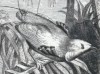
A devilfish painted by Georg Forster in the 1770s.Credit: NHM Coll./Mary Evans
British mariner James Cook, a veritable astronaut of the Enlightenment, set out on his voyages to the Pacific 250 years ago with well-chosen crews, many talented with brush and pen. Among them were father and son Johann and Georg Forster, as well as Sydney Parkinson and William Hodges. The Endeavour expedition changed our understanding of the cosmos, as astronomers used its observations of the 1769 transit of Venus across the Sun to measure Earth’s distance from our star.
Cook was fond of the phrase “voyages of discovery” to describe his travels. Yet this brilliant cartographer, who journeyed emotionally and intellectually into waters unknown to him, encountered people from cultures that had navigated, voyaged and built understanding of their own marine environment for centuries. Tahitians, Hawaiians and Maori people would place this enigmatic visitor on their own maps in ways he could neither understand nor control. Consider Tahitian navigator Tupaia, whose knowledge of the Pacific’s ‘sea of islands’ hugely assisted Cook. For generations of Polynesian voyagers, the sea was not so much an obstacle as a way.
Cook’s exploits, charts, life and violent death in Hawaii have given him equal celebrity and notoriety. Less known is a young British vicar with a passion for mathematics, who held the fortunes of men, and nations, in his hands — by arbitrating a contest for new precision equipment. In 1763, Nevil Maskelyne was sent to Barbados to test a ‘sea watch’ devised by clockmaker John Harrison in a navigational arms race whose outcome would transform the world. Maskelyne’s days were spent minutely inking out calculations as his ship lurched across the Atlantic.
His reward was to be made astronomer royal in 1765. He published the first volume of The Nautical Almanac two years later. This celebrated work contained a table of lunar distances for computing longitude, and was assembled with a team of human ‘computers’ — assistants versed in arithmetic, geometry, trigonometry and observational acuity.
Mapping information
A generation later, Irish hydrographer Francis Beaufort orchestrated one of the greatest mapping exercises ever attempted. With British merchant and naval fleets commanding the seas, it was Beaufort’s job at the Hydrographic Office of the Admiralty to track information on which ships relied, from where to lay anchor to intelligence about fortification and trade. Officers’ naval journals were crammed with such data, and Beaufort’s Admiralty charts became the gold standard. In them, centuries of the art and science of seafaring are distilled into two dimensions and half a square metre.

An 1817 map of the south coast of Anatolia, surveyed by Francis Beaufort.Credit: Picture Art Coll./Alamy
Along with devising an eponymous wind-force scale in 1805, Beaufort was a prime mover behind the Admiralty’s Manual of Scientific Enquiry, first appearing in 1849. This contained instructions for observation in a dizzying range of new disciplines — a scientific A–Z from astronomy to zoology, by way of botany, geology, hydrography, magnetism, mineralogy, statistics and tides. Charles Darwin and botanist William Hooker contributed essays. From a time when British surveying vessels could be found in New Zealand, the Torres Strait and the Arctic, this monumental work is a snapshot of UK domination of the seas. Its instructions for seafarers were clear: “Let him then acquire the habit of never quitting his ship without his note-book and pencil, and his pocket-compass.”
As Victorian science gave way to the twentieth century’s game-changing discoveries — from continental drift to other galaxies — British rule of the oceans ebbed. The journal habit did not. The 1915 Nature Notes for Ocean Voyagers, co-authored by sea captain Alfred Carpenter, was filled with his “personal observations upon life in the ‘vasty deep’” — one of the earliest spotters’ guides to marine wildlife. He was assisted by scholar-sailor David Wilson Barker, who had ferried passengers to gold-rush Australia and served on iron ships laying submarine cables on the ocean floor. Barker was a keen observer of seabird migrations and the shapes of waves, and found time to sketch the aurora australis and discover remarkable plankton blooms off the coast of Ecuador. An author of seamanship and navigation manuals, he also penned the 1918 Things A Sailor Needs to Know.
By the 1930s, US oceanographer and zoologist William Beebe was enrapturing the world with radio commentary delivered from a research submarine, the ‘bathysphere’, hundreds of metres down in Bermuda waters. Beebe headed the Department of Tropical Research at the New York Zoological Society and encouraged female scientists to work with him. Of the many who joined his expeditions, Gloria Hollister is particularly interesting. A trained zoologist and cancer researcher, she applied to work with Beebe in 1928, as he was looking for a professional naturalist, with skills in dissection, for an expedition to Bermuda. Hollister became invaluable as an experienced ichthyologist, and she made research descents in the bathysphere. Her observational skills, and talent with paint and ink, turned Beebe’s scientific discoveries into true works of art.

Gloria Hollister, William Beebe and John Tee-Van with the bathysphere in which they made descents into the waters off Bermuda.Credit: Bettman/Getty
Hollister eventually led three expeditions herself. In Trinidad, she explored the Arma Gorge and studied the oilbird (Steatornis caripensis), the world’s only nocturnal flying, fruit-eating bird. In 1936, she embarked on an expedition to Guyana’s Kaieteur Falls, trekking through more than 300 kilometres of dense tropical jungle. With her team, she discovered species and brought back specimens, including the curiously reptilian-looking stinkbird, or hoatzin (Opisthocomus hoazin). In the early 1950s, she co-created the Mianus River Gorge Conservation Committee, saving this habitat in Bedford, New York, from development. Throughout, Hollister, like Beebe, kept extensive logs and notes. Her career began, as many other field scientists’ did, with discoveries made from the shifting deck of a ship.
In the pages of rare journals and sea logs, private diaries and cloth-bound sketchbooks, there is much for historians of science to discover. Observation remains at the heart of scientific effort, and worlds are still there for the exploring — from the microbiome to the sea bed and into deep space. As the Renaissance humanist Petrarch put it, people go forth to behold “the mighty surge of the sea ... the inexhaustible ocean, and the paths of the stars”. And in so doing, they “lose themselves in wonderment”.
 In retrospect: The Malay Archipelago
 Polar exploration: The forgotten journey
 Frozen assets