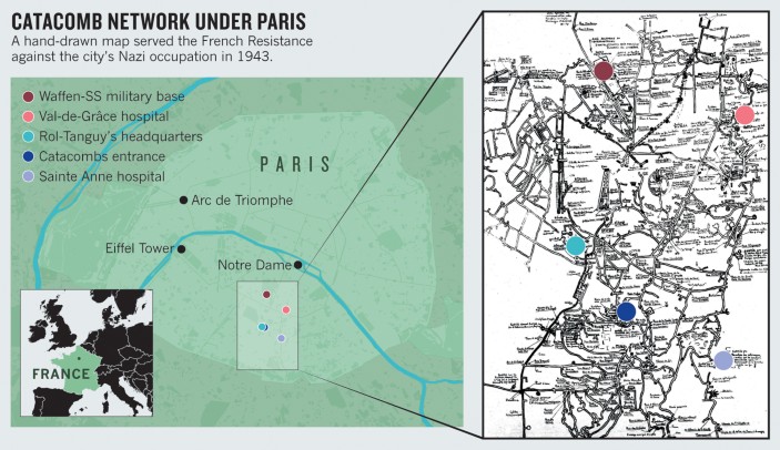
Neurosurgeon Jean Talairach (1911–2007) created his pioneering brain atlas with his colleague Gabor Szikla in 1967. Almost three decades earlier, he had painstakingly drawn a quite different map — of Paris's subterranean ossuaries (see 'Catacomb network under Paris'), a copy of which we recently unearthed in the archives of the city's Sainte Anne Hospital. The map served as a crucial guide in the liberation of the French capital from the occupying Nazis during the Second World War.

While working at the hospital in 1938, Talairach and his colleague René Suttel picked the lock of a secret door in the historic building to gain access to the city's catacombs. This maze of passageways lies south of the River Seine and comprises more than 100 kilometres of underground galleries (R. Suttel Catacombes et Carrières de Paris; Châtillon, 1986).
To make the map, Talairach used distinctive points of reference such as inscriptions, groups of skulls, doors and manholes. He then measured the angles and distances between those points — the same principles he later applied in his 3D plan of brain coordinates.
In 1943, the two junior doctors passed the map to a commander in the French Resistance, Colonel Henri Rol-Tanguy. The macabre guide gave him subterranean proximity to the Nazi SS base and enabled him to coordinate the Battle for Paris (19–23 August 1944) from his underground headquarters, until the Allies entered the city on 24 August. After the victory, Talairach was awarded the War Cross, France's highest military distinction.
Author information
Authors and Affiliations
Corresponding author
Rights and permissions
About this article
Cite this article
Bourdillon, P., Lévêque, M. & Apra, C. Paris neurosurgeon's map outwitted Nazis. Nature 547, 281 (2017). https://doi.org/10.1038/547281a
Published:
Issue Date:
DOI: https://doi.org/10.1038/547281a
