


« Prev Next »
Introduction
Geologic erosion is a natural process through which wind, water and ice have carved the earth's surface for thousands of millennia. The Grand Canyon is a particularly dramatic example — a 4 trillion cubic meter slice through approximately 2 billion years of geologic history (Figure 1). Natural erosional processes occur most intensively in mountainous regions (Figure 2) and generate approximately 20 gigatons of sediment annually (Wilkinson and McElroy 2006). In comparison, human geomorphic activities, principally agriculture, construction and mining mostly occur at lower elevations and annually move more than 100 gigatons of earth materials (Hooke 2000). Humanity has surpassed the timeless contest between uplift and erosion as the dominant agent of geomorphic change.
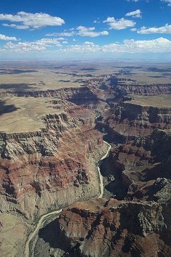

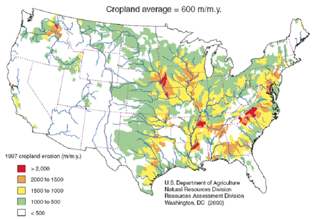
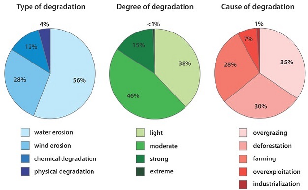
Figure 1: Aerial view over the north part of the Grand Canyon.
Courtesy of Hendric Stattmann via Wikimedia Commons. Some rights reserved. 
Figure 2: Variation in natural erosion rates across the contiguous US.
Used with with permission from Bruce H. Wilkinson and Brandon J. McElroy. All rights reserved.
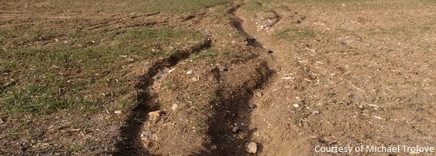
While a growing portion of anthropogenic earth moving involves deliberate engineering, about 70% of the geomorphic activity tallied by Hooke (2000) is the unintentional side effect of land-use practices that accelerate soil erosion. Human activities that significantly reduce soil cover (e.g., tillage and clear-cutting) and/or intensify wind or water movement (e.g., the removal of windbreaks and channelization of streams) often result in accelerated erosion that exceeds geologic erosion rates by several orders of magnitude (Figure 3).
Figure 3: Variation in accelerated erosion rates on cropland in the contiguous US.
Used with with permission from Bruce H. Wilkinson and Brandon J. McElroy. All rights reserved.
In light of the ever growing demand for agricultural products and the environmental consequences of converting virgin land to agriculture, it is critically important that humanity minimize the erosion of agricultural soils and restore the productivity of soils that have already been degraded by erosion. Water erosion is the most widespread form of soil degradation globally (Figure 4) and its prediction, prevention and remediation is the focus of this article.
Figure 4: Types, degree and causes of global land degradation.
© 2013 Nature Education All rights reserved.
Accelerated water erosion: causes and effects
Water erosion involves three main processes: detachment, transport and deposition (Figure 5). Recognition of the important role played by raindrop impact in detaching soil particles was a major breakthrough in scientific understanding of water erosion. Earlier concepts incorrectly viewed detachment as primarily resulting from surface flow (Brady and Weil 2008). Dissipation of the kinetic energy in raindrops by living and dead plant residues helps to prevent detachment in conservation tillage systems.
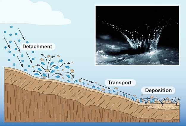
Figure 5: Primary mechanisms of water erosion.
From Brady and Weil 2008. All rights reserved.
Practices that increase infiltration such as cover cropping and tile drainage reduce run-off and thus limit the transport of detached particles. Practices that slow run-off, such as terraces and buffer strips, promote deposition of suspended sediment before it leaves the field. Reduction and deceleration of run-off also limits the scouring effects of concentrated surface flow (Figure 6).
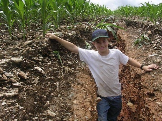
Figure 6: Gully formed during 14.8" of rain over 4 days in late June 2006 in Holtwood, PA.
Used with with permission from Steve Groff. All rights reserved.
Accelerated water erosion degrades agricultural soils in three main ways: loss of organic matter, diminished nutrient supply, and impaired hydrologic function. These prevailing effects, and more regional challenges such as subsoil acidity, fragipans and shallow depth to bedrock have been intensively investigated (reviewed by Lal 1998), yet quantitative erosion-productivity models have not been developed for most soils (Shaxson 2006). The impact of soil loss and redistribution by erosion on crop productivity is hard to predict due to the complex interactions among modulating factors such as antecedent soil properties, topography, weather, crop genetics and advances in farming practices. In addition, the prediction of soil loss, while commonly thought to be a routine exercise using user-friendly models such as RUSLE2, is actually quite difficult. Trimble and Crosson (2000) provide a powerful critique of the over-reliance on models and lack of physical field-based measurements in the study and management of soil erosion. One of the biggest challenges in predicting water erosion is that most soil loss occurs during extreme precipitation events that are inherently stochastic (Groffman 1997). Another challenge is that tillage erosion, the down-slope movement of soil during tillage operations, is the primary cause of soil movement in many undulating agricultural landscapes, but is difficult to distinguish from water erosion (Lindstrom 2006). Finally, there is disagreement within the conservation community about the relative importance of total soil loss versus changes in key soil properties such as texture, water-holding capacity and nutrient supply (Shaxson, 2006).
Investigation of erosion-productivity relationships
Considering the diversity of methods employed in the investigation of erosion-productivity relationships, a brief review of methods is warranted. For more detailed discussion, see reviews by Olson et al. (1994), Lal (1998) and Biggelaar et al. (2004 I and II). 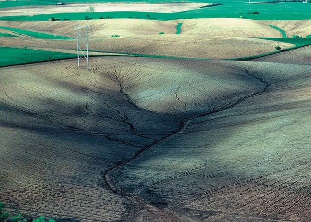
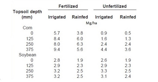
According to Langsdale and Shrader (1982), the most widely used method of investigating erosion-productivity relationships is topsoil ‘cut and fill', also known as ‘removal and addition'. This approach simulates different levels of erosion by using excavation equipment to create plots with specific depths of topsoil or specific depths of topsoil removal/addition (see Table 2 for an example of the results from this type of study). While clearly appropriate for evaluating the effects of land forming, some scientists question this method's relevance to the study of water erosion because one-time, uniform modification of topsoil depth is mechanistically very different from the preferential removal of organic matter and fine mineral fractions by water erosion. The dendritic pattern of removal and deposition by water erosion is also distinctly different from soil movement by excavation equipment (Figure 7). Olson et al. (1994) concluded that adding incremental amounts of topsoil to eroded soil better simulates different levels of erosion than simply removing topsoil.
Figure 7: Severe sheet and rill erosion in northwest Iowa after heavy rains.
Photo by Lynn Betts/NRCS, 1999. Some rights reserved.
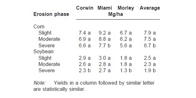
Another widely used approach involves comparison of crop and soil parameters across sites with varying levels of historical erosion - often within specific soil types or landscape positions (Bruce et al. 1988). This approach works best in landscapes where it is possible to accurately characterize erosion history. In some cases, comparable uncultivated sites are included. Many data sets showing adverse effects of erosion on crop yield have been collected (e.g., Table 3), yet data interpretation is often confounded by factors such as differences in antecedent soil properties and underlying geology or hydrology.
Other methods of investigating the effects of erosion on crop productivity include greenhouse studies, intentional erosion plots in which erosion is promoted for study purposes), statistical methods such as factor analysis, and simulation models (Olson et al. 1994; Lal et al. 1998)
Soil loss tolerance
Within the realm of soil conservation policy within the United States, soil erosion has commonly been described in relation to soil-specific tolerance levels (commonly called t-factors) officially designated as levels of soil loss that can be tolerated without compromising long-term soil productivity. One might logically assume that t-factors are similar to soil production rates. The reality is that they are based on the best judgments of USDA agency staff. Some within the soil science research community are concerned that t-factors are substantially higher than soil production rates because of political and economic considerations (Keeney and Cruse 1998). 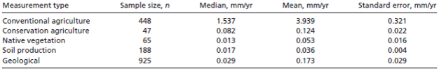
Most t-factors range from 5 to 11 megagrams per hectare (Mg/ha), with the most productive soils having the highest t-factors. (Assuming a bulk density of 1,200 kilograms per cubic meter, 11 Mg/ha is equivalent to an annual loss of 0.9 millimeters of soil). Estimates of soil production rates are generally 1-2 orders of magnitude lower than t-factors (Table 1).
Table 1: Variation in estimated rates of soil erosion and production.
From Montgomery 2007. All rights reserved.
Table 2: Impact of fertilizer, irrigation and topsoil depth on grain yield.
From Thompson et al. 1991. All rights reserved.
Table 3: Varying effects of erosion phase on grain yield across 3 soils in Indiana.
From Schertz et al. 1989. All rights reserved.
One serious limitation of the t-factor concept is the emphasis on on-site costs of erosion, when off-site costs tend be substantially greater (Pimentel et al. 1995). Another serious limitation is that productivity decline associated with erosion tends be more related to the degradation of soil as a rooting environment and the soil surface as an interface allowing exchange of gases and water, than to the specific quantity of soil lost to erosion (Shaxson and Barber 2003). Despite these limitations, t-factors have served a valuable role in focusing attention on erosion's long term effects on crop productivity.
Importance of antecedent soil properties
Antecedent soil properties clearly have a large impact on how erosion affects crop productivity. Fertile soils with thick loess or alluvial parent material can experience high rates of erosion for many years with relatively little loss of productivity. In contrast, moderate soil loss can cause major declines in the productivity of soils with limited rooting depth. For example, an Ultisol with a fragipan at 30 centimeters would tend to be much more negatively impacted by the loss of 10 centimeters than a Mollisol with a 60-centimeter thick A horizon.
Remediation of eroded soils
Early studies of the effects of erosion on crop productivity in the United States (1935-1950) focused primarily on soil fertility. Many authors reported that reductions in yield due to erosion (simulated or real) could be restored by applications of nitrogen and phosphorus fertilizers and sometimes micronutrients (Langdale and Shrader 1982). As fertilizer use became more common, many investigators shifted their attention to organic amendments and their restorative effects on soil structure and hydrologic function. Larney et al. (2000) reported that the relative advantage of organic amendments over inorganic fertilizers is inversely related to the organic matter content of degraded sites. In developing countries, erosion effects on nutrient supply remain a dominant concern (Asio et al. 2006). 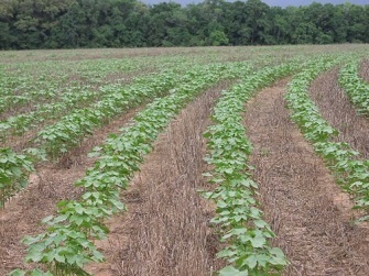
Since the 1980s, many studies have explored the capacity of conservation tillage systems to remediate eroded soils. Continuous no-till cropping systems with cover crops (Figure 8) have been found to be particularly effective because of their ability to quickly enhance levels of organic matter near the surface. (Langdale et al. 1992; Bruce et al. 1995). Elevated organic matter levels in the top several centimeters of an eroded soil can dramatically increase water infiltration, nutrient cycling and resistance to detachment (Franzluebbers 2002).
Figure 8: No-till cotton planted into a cover crop.
Photo via NRCS/USDA. Some rights reserved.
Case study: Quesungual — an eco-efficient method of enhancing crop yields and soil quality
Quesungual is a village in southwest Honduras whose name derives from indigenous words for soil, vegetation and a convergence of streams. Unfortunately, the village's once abundant soil and water resources were severely degraded by traditional slash and burn farming practices (Figure 9). The silver lining is that a partnership between village farmers and development organizations in the early 1990s led to the development of a new ‘eco-efficient' system of agriculture known as the Quesungual Slash and Mulch Agroforestry System (QSMAS). The system is based on four key principles: no burning, no tillage, permanent soil cover and efficient use of fertilizer. It has reduced erosion and improved crop yields and quality of life for over 6,000 local families while allowing regeneration of about 60,000 hectares of secondary forest (New Agriculturalist 2009). 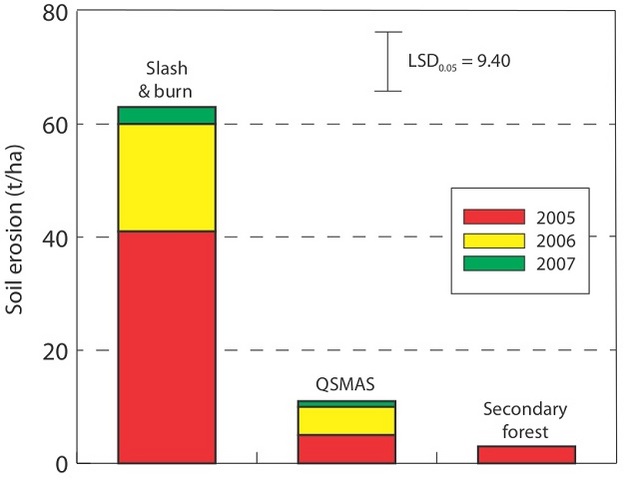
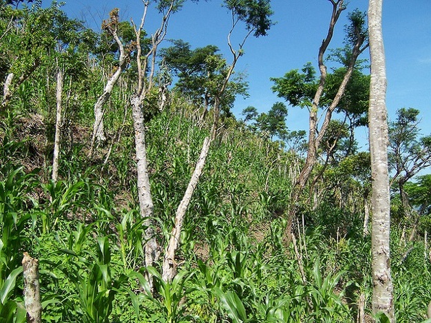
Figure 9: Erosion rates associated with traditional slash and burn, the Quesungual system and secondary forest.
© 2013 Nature Education All rights reserved.
The system starts with selective harvesting and pruning of natural vegetation. Trunks and large branches are used for firewood and timber, while smaller vegetation is spread as mulch. During the first year, farmers broadcast pioneer crops like sorghum and beans, which grow up through the mulch. In subsequent years, maize is the primary crop. The trees and shrubs dispersed throughout fields are aggressively pruned several times a year to produce mulch and prevent excessive shading of crops. The decomposing mulch supplies crops with nutrients, although additional fertilizer is often used (New Agriculturalist 2009).
The QSMAS is an agroforestry system with three main layers of vegetation: trees/shrubs, crops, and mulch. These layers dissipate the kinetic energy of raindrop impact, improve infiltration and increase water retention (Figure 10). The result is improved water availability for crops. Farmers view the Quesungual System as a method of enhancing crop productivity that also happens to minimize soil erosion (Hellin 2003).
Figure 10: Appearance of vegetation in the Quesungual system soon after planting.
Used with with permission from Steve Fonte. All rights reserved.
Landscape restoration
The redistribution of topsoil from historical sediment deposition sites to eroded landscape positions is a more intensive remediation strategy that has been used for centuries by traditional farmers around the world (e.g., China and France), although it has received little attention by modern agriculture. Recently a few innovative farmers and scientists in Canada and the United States have begun experimenting with this approach, referred to as landscape restoration in the scientific literature, using modern agricultural technology.
Case study: Landscape restoration — restoring productivity through topsoil redistribution
Dr. David Lobb, with the Department of Soil Science at the University of Manitoba in Winnipeg, Canada, investigates soil-landscape variability, its causes, characterization and management. His research has shown that eroded upper landscape positions yield poorly but can be dramatically improved by the addition of topsoil. He considers the redistribution of topsoil from deposition areas to source areas similar to other capital-intensive land improvement practices such as tile drainage or irrigation. In a recent interview (Flookes 2008), Lobb stated that ‘our economic work on landscape restoration suggests that farmers can get high (enough) returns from improved yields that it can pay for itself in a few years. Then if you don't use practices that erode hilltops further, you will have that benefit for decades'. 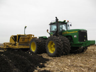
Dallas Timmerman, a grain and livestock farmer in Treherne, Canada, collaborated with Lobb and graduate student Diane Smith to quantify the benefits of landscape restoration. In the fall of 2004, a two-year project was initiated on four eroded hilltops on the Timmerman farm. Ten centimeters of topsoil were added to half of each hilltop, while the other half was left unamended. In 2006, field pea yields were 64 percent higher on the restored plots. At other project sites near the Timmerman farm, wheat yields and flax yields were 128 percent and 94 percent higher, respectively, on restored hill tops (Flookes 2008).
Smith reported: ‘Overall, the study shows that by restoring eroded hilltops, there can be significant improvement in yields and economic returns' and ‘...restoring eroded landscapes is a logical, innovative and practical strategy for farmers to implement in their operations' (Flookes 2008).
While the movement of large amounts of soil is inherently energy intensive, precision agriculture technologies offer the potential to optimize the efficiency of topsoil redistribution. Clay Mitchell, a young farmer at the forefront of precision agriculture, recently began experimenting with using computer modeling and GIS/GPS to guide landscape restoration on his family's 2,500-acre grain farm in north central Iowa, United States.
He started by using yield monitor and topographic data to identify areas that performed poorly due to historical topsoil loss. Identifying depositional areas with excess topsoil was the bigger challenge. He started by removing soil from the edges of waterways and redistributing it to distinct ‘poor soil anomalies' within fields (Schrimpf 2009).
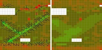
The next stage of the project engaged graduate students in Agricultural Engineering at Cornell University in an optimization problem. Working from maps of relative yield and topsoil depth, a team of four students developed software for planning the optimal redistribution of topsoil across an agricultural landscape, taking into account the workload involved in moving topsoil from one place to another (Ju 2009). They predicted that a one-time expenditure of less than $1,000 on topsoil redistribution using a satellite-guided tractor and scraper (Figure 11) following optimal routes (Figure 12) could increase profitability by $9,000 per year.
Figure 11: Tractor and scraper on the Mitchell Farm.
Used with permission from Clay Mitchell. All rights reserved.
Figure 12: Optimized routes for topsoil redistribution on the Mitchell Farm.
Used with permission from Clay Mitchell. All rights reserved.
Conclusion
Intensive research has evaluated the effects of accelerated water erosion on crop productivity. Loss of nutrients to erosion, while historically significant, is largely reversible using nitrogen and phosphorus fertilizers. Loss of hydrologic function is a much more serious challenge but gradual restoration is possible through practices that raise organic matter levels, especially at the soil surface. Farming system strategies that minimize tillage, maximize living cover (e.g., the QSMAS system), and utilize additional organic inputs (e.g., animal manures) have a strong track record of restoring the productivity of soils degraded by water erosion. Mechanical redistribution of topsoil from catchment areas to denuded areas, also known as landscape restoration, appears to have promise in some agricultural landscapes, especially when precision agriculture technologies can be used to optimize the efficiency of topsoil transfer.
Glossary
accelerated erosion - erosion intensified by human activity
antecedent soil properties - soil properties prior to an event such as tillage or erosion
anthropogenic - resulting from human activity
buffer strips - a strip of perennial vegetation (typically at least 10 m wide) designed to slow run-off and increase deposition of suspended materials
clear-cutting - logging practice in which most or all trees in a harvest area are cut down.
conservation tillage - tillage practices that help prevent soil erosion by maintaining at least 30% residue cover
cover cropping - vegetation established between cash crops with the intention of erosion control and/or soil improvement
deposition - the process through which mobile sediment loses kinetic energy and accumulates
detachment - the fragmentation of soil structural units into sediment (primary particles or smaller aggregates) resulting in greater potential for transport
factor analysis - a multivariate statistical approach that can be used to analyze relationships between a large number of variables with the goal of explaining the variables in terms of their common underlying dimensions (factors) i.e., condensing the information contained in the original variables into a smaller set of dimensions (factors) with a minimum loss of information
fragipan - natural subsurface soil layers that restrict air and water flow and root penetration
geologic erosion - background or natural rates of lowering of earth surfaces without human influence
geomorphic change - alteration of the shape of a land form
Gigatons (Gt) - 1 billion metric tons, 1 x 10¹⁵ g
GIS - an acronym for Geographic Information System, a system designed to store, manipulate, analyze, manage, and present geo-referenced data
GPS - an acronym for Global Positioning System, a navigation system using radio communication with a network of 3 or more satellites to determine the location, velocity, and time 24 hours a day anywhere on or above the earth's surface
GIS/GPS - a modifier used to indicate a technology that integrates GIS and GPS
gully erosion - movement of soil by flowing water, forming relatively broadly spaced channels that can not be filled in by normal tillage operations
hydrologic function - the capacity of a soil to perform processes involving water movement and storage
land degradation - the loss of key land functions (e.g., water storage and filtering, wildlife habitat, primary production...)
land forming - the use of excavation equipment to truncate or add to soil profiles, changing soil depth and surface topography
loess plateau - a land form composed of a thick accumulation of wind deposited mostly silt sized sediment resulting from glaciation
Mollisols - a soil order in USDA Soil Taxonomy that forms under prairie vegetation and is characterized by a deep dark surface horizon, rich in organic matter
off-site costs - damages that occur sufficiently remote from the original site of erosion that the damages do not directly affect the land manager
on-site costs - damages associated with erosion that directly impact the manager of the land experiencing the erosion
precision agriculture - the application of technologies and agronomic principles to increase production efficiency by adjusting for spatial and temporal variability in agricultural systems
rill erosion - movement of soil by flowing water forming relatively closely spaced small channels that can be filled in by normal tillage operations
RUSLE2 - Revised Universal Soil Loss Equation version 2 - a computer program that estimates annual soil loss totals in tons/acre caused by water erosion, useful for comparing practices, much less valuable for predicting absolute levels of soil loss
sheet erosion - detachment of soil particles primarily by raindrop impact and their movement by water flowing overland as a sheet instead of concentrated flow
slash and burn - a traditional form of agriculture used primarily in tropical areas that involves cutting and burning forest vegetation to prepare for several seasons of crop production before the forest is allowed to regenerate
soil erosion - the movement of surface soil by water or wind that may be accelerated by human activities that remove surface cover, reduce structural stability or increase run-off/wind speed
soil production - the transformation of non-soil parent material such as rock into soil (rate is generally comparable to geologic erosion)
stochastic - an adjective that refers to systems whose behavior is sporadic and categorically NOT periodic
t-factor - an estimate by the Natural Resource Conservation Service (or Soil Conservation Service prior to 1992) of the maximum average annual rate of soil erosion that can occur without negatively affecting crop productivity over the long term
terrace - an embankment or ridge of earth constructed across a slope to control runoff and minimize soil erosion
tile drainage - the use of sub-surface drain lines, originally made of terra-cotta tile but now normally made of plastic, to accelerate lateral movement of soil water
tillage - the mechanical modification of soil structure that generally increases susceptibility to erosion
transport - the movement of sediment following detachment
Ultisols - a soil order in USDA Soil Taxonomy that forms under forest vegetation and is characterized by a high degree of weathering and horizon development, often including very acid sub-soil
windbreak - one or more rows of trees or shrubs planted to provide shelter from the wind
yield monitor - an electronic system of monitoring and geo-referencing grain yield and moisture content while harvesting.
References and Recommended Reading
Asio, V.B. et al. A review of soil degradation in the Philippines. Annals of Tropical Research 31. (2009)
Biggelaar,
C. et al. The global impact of soil
erosion on productivity I: Absolute and relative erosion-induced yield losses. Advances in Agronomy 81. (2004)
Biggelaar, C. et al. The global
impact of soil erosion on productivity II: Effect on crop yields and production
over time. Advances in Agronomy 81. (2004)
Brady, N.C. and Weil, R.R. The Nature and Properties of Soils. Upper Saddle River, NJ: Prentice Hall. (2008)
Bruce, R.R. et al. Characterization of soil-crop yield relations over a range of erosion on a landscape. Geoderma 43. (1988)
Bruce, R.R. et al. Surface soil degradation and soil productivity restoration and maintenance. Soil Science Society of America Journal 59. (1995)
Flookes, E. (ed.) Field Restoration: why organic matter matters, New Ground (2008).
Franzluebbers, A.J. Soil organic matter stratification ratio as an indicator of soil quality. Soil & Tillage Research 66. (2002)
Groffman P.M. Ecological constraints on the ability of precision agriculture to improve the environmental performance of agricultural production systems. Ciba Foundation Symposium 210. (1997)
Hellin, J. From soil erosion to soil quality. LEISA 19. (2003)
Hooke, R.L. On the history of humans as geomorphic agents, Geology 28. (2000)
Ju, A. Iowa farmer turns to engineering students for (hypothetical) help reclaiming valuable topsoil. Cornell Chronicle Online. (2009)
Keeney, D. and Cruse, R. The connection between soil conservation and sustainable agriculture. In Advances in Soil and Water Conservation, eds. Pierce FJ and WW Frye. (Ann Arbor, MI: Chelsea, 1998).
Lal, R. Soil erosion impact on agronomic productivity and environment quality. Critical Reviews in Plant Sciences 17. (1998)
Langdale, G.W. and Shrader, W.D. Soil erosion effects on soil productivity of cultivated cropland. Determinants of soil loss tolerance. Special Publication 45. (Madison, WI: American Society of Agronomy, 1982)
Langdale, G.W. et al. Restoration of eroded soil with conservation tillage. Soil Technology 5. (1992)
Larney, F.J. et al. Early impact of topsoil removal and soil amendments on crop productivity. Agronomy Journal 92. (2000)
Lindstrom, M.J. Tillage erosion: Description and process. In Encyclopedia of Soil Science. 2nd edition, ed. Lal, R. (New York, NY: Taylor & Francis). 2006.
Montgomery D.R. Soil erosion and agricultural sustainability. Proceedings of the National Academy of Sciences USA 104. (2007)
New Agriculturalist. Ancient lesson in agroforestry — slash but don't burn. (2009)
Pimentel, D. et. al, Environmental and Economic Costs of Soil Erosion and Conservation Benefits. Science 267. (1995)
Schertz, D.L. et al. Effect of past soil erosion on crop productivity in Indiana. Journal of Soil and Water Conservation 44. (1989)
Schrimpf, P. Clay Mitchell: Extreme makeover. PrecisionAg.com (2009)
Shaxson, T.F. and Barber, R.G. Optimizing soil moisture for plant production — the significance of soil porosity. FAO Soils Bulletin No. 79. (Rome: Food and Agriculture Organization of United Nations, 2003)
Shaxson, T.F. Re-thinking the conservation of carbon, water and soil: a different perspective. Agronomie 26. (2006)
Thompson, A.L. et al., Topsoil depth, fertility, water management, and weather influences on yield. Soil Science Society of America Journal 55. (1991)
Trimble, S.W. and P. Crosson. U.S. Soil Erosion Rates: Myth and Reality. Science 289. (2000)
Wilkinson, B.H. and McElroy, B.J. The impact of humans on continental erosion and sedimentation. Geologic Society of America Bulletin 119. (2006)