


« Prev Next »
Classification of Coastal Dunes
Depending on the characteristics and availability of the sediment supply, dominant wind velocity and direction, moisture and vegetation present, and the geomorphology of the nearshore and beach face, dunes of various size and morphology are formed (for processes on aeolian transports see Sloss et al. this issue). Sand deposition, accretion, and erosion within the coastal environment result in the development of a variety of dune morphologies; however, a general classification into primary and secondary dunes can be made (Davis 1980, Masselink & Hughes 2003). Primary dunes are composed of sand blown directly from the beach face (active beach), whereas secondary dunes develop following the subsequent modification of primary dunes.
Primary Dunes
Davies (1980) defined "primary dunes" as dunes with a sand supply derived primarily from the beach and "impeded primary" dunes as those in which vegetation plays a major role (i.e., impedes downwind transport) in the development of the dune. They are the dunes closest to the shoreline, dynamically linked to beach processes, and significantly influenced by wave action as both a constructional and erosional force.
Foredunes
Foredunes develop at the rear of the backshore environments (landward of the active beach) and generally comprise shore-parallel, convex, symmetrical to asymmetrical dune ridges. The morphology of foredunes is varied but they can be classified into three main types: incipient foredunes, established foredunes, and relict foredunes (Short & Hesp 1982, Hesp 2002).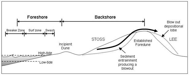
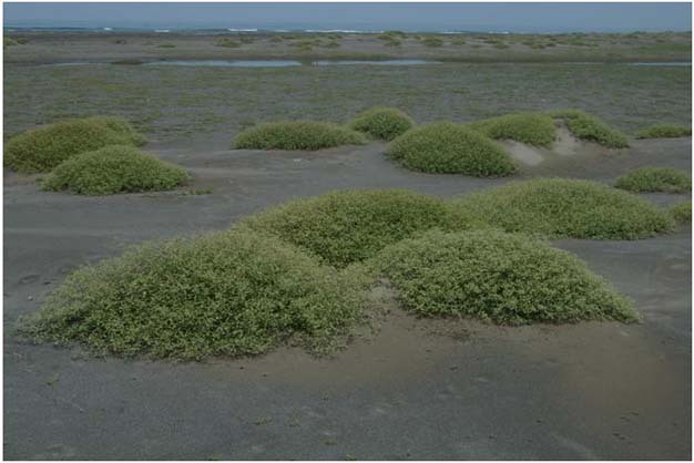
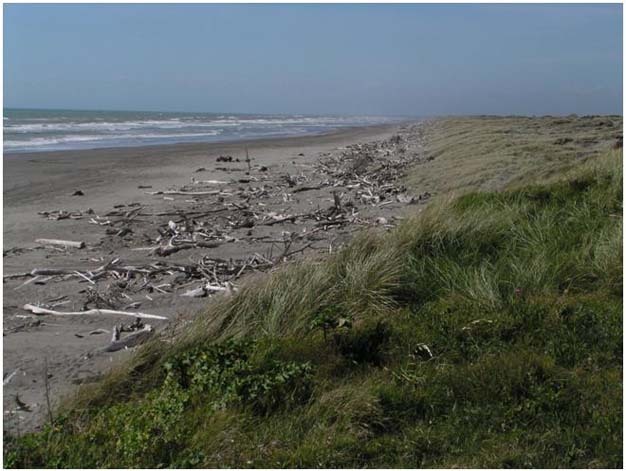
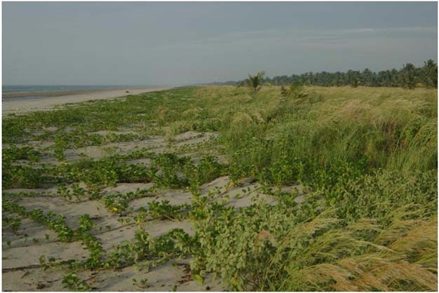
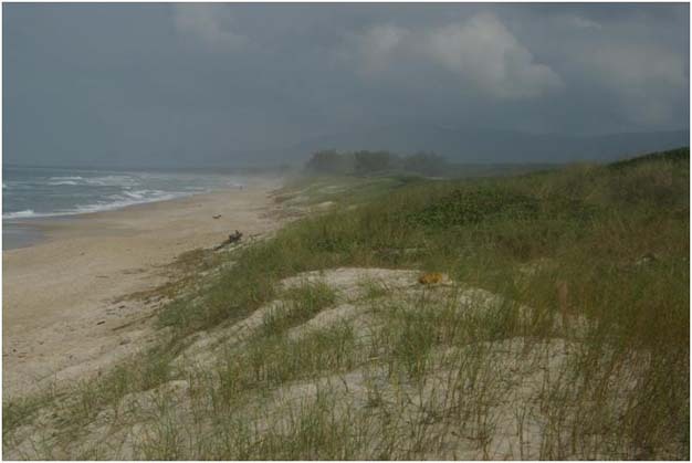
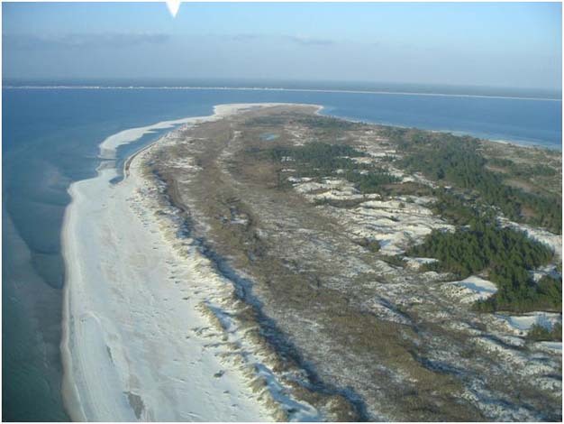
Figure 1
The beach-dune system showing the nearshore zone back-beach environment and the formation of an incipient foredune and established foredune.
© 2012 Nature Education Reprinted with permission: Komar 1976 and Hesp 1999, 2002. All rights reserved. 
Incipient foredunes are the initial dunes which accumulate above the high spring tide mark and form due to the presence of some roughness element at the rear of the beach that rapidly reduces wind flow velocities, resulting in sediment accumulation (Figure 1; Hesp 1999, 2002, Sloss et al. this issue). Driftwood sometimes forms the focus for the initial accumulation of dune sand, but vegetation is the most common roughness element that contributes to the formation of incipient dunes (Figure 1, photos 1–3). Incipient foredunes are sometimes ephemeral features, tending to be eroded or completely removed by severe storm events at irregular intervals varying from a few months to several years, but they may survive and grow to become a larger established foredune, or become relict and stable as a new incipient foredune develops to seaward (Hesp 1999, 2002).
Photograph 1
Small hummocks (termed nebkha) formed by sand deposition within discrete plants on the backshore at Dona Juana dunefield, Mexico.
© 2012 Nature Education Reprinted with permission: P. Hesp. All rights reserved.
Photograph 2
Driftwood and coastal vegetation acting as a roughness element and stimulating incipient formation on the Manawatu coast of the southwest of the North Island of New Zealand.
© 2012 Nature Education Courtesy of C. Sloss. All rights reserved.
Established foredunes (sometimes termed the "frontal dune") also originate at the landward edge of the beach, parallel to the shoreline. They develop from an incipient foredune and have a greater height, width, age, and/or morphological complexity (Hesp 2002). As an incipient foredune builds up, and out, sand inundation and salt spray levels decrease, while nutrient levels and vegetation cover increase, resulting in more stable dunes. The lee slope (i.e., the landward slope) is gradually often (but not always, depending on the latitude and coastal climate) colonised by a range of "woody" or shrub plant species that prefer more stable conditions (Hesp 1999, 2002). Sand is gradually deposited on the seaward slope, and sometimes the crest of the dune, which slowly becomes larger, forming an established foredune (Figure 1, photos 2–4).
Photograph 3
Incipient foredune forming in Ipomoea plants and grasses, Yucatan coast, Mexico.
© 2012 Nature Education Reprinted with permission: P. Hesp All rights reserved.
Photograph 4
Established foredune in southern Brazil.
© 2012 Nature Education Reprinted with permission: P. Hesp. All rights reserved.
Foredunes tend to be largest at the rear of dissipative beaches because of higher sand transport rates, but other factors may also influence foredune height. Particularly important is the length of time a foredune remains adjacent to the beach receiving windblown sand. If not eroded away or replaced seaward by a new foredune, elevations of 20 m or more may be reached, but the higher the dune the greater the wind shear and the greater the likelihood of blowouts (erosional saucer and trough-shaped hollows). Foredunes are lower where a coast has prograded (built seawards) rapidly. This is because the rapid growth of each new foredune to seaward cuts off the supply of windblown sand to the previous foredune before it can accrete (build upwards) to a significant height (Hesp 2002).
If the sediment supply is adequate, a new incipient dune may form seaward of the established foredune, resulting in the established foredune being relatively isolated from the sediment supply. The isolation of the dune, coupled with coastal progradation, can result in the development of successive foredunes that may eventually form a wide foredune plain (photo 5). This may consist of dozens to hundreds of relict foredune ridges, which are usually parallel with the coast and mark former shoreline positions (Hesp 2002). The best examples, with relatively unmodified ridges, are of Holocene age, while older Pleistocene dunes generally have a more subdued topography, with greater soil development and often indurated horizons.
Photograph 5
A modern foredune and relict foredunes forming a foredune plain at Cape San Blas, Florida. Note that bars are migrating alongshore, attaching to the beach and providing new sediment to both prograde the beach and build new foredunes.
© 2012 Nature Education Reprinted with permission: P. Hesp. All rights reserved.
Secondary Dunes
Secondary dunes are the result of the subsequent modification of the "primary dune" by continued aeolian processes, and are generally located further inland, separated from nearshore processes (Davies 1980). The main secondary dunes include blowouts, parabolic dunes, and transgressive dunefields (Figures 2 and 3). Note, however, that parabolic and transgressive dunefield dune types may also occur directly from the beach, and are therefore also primary dunes when this occurs.
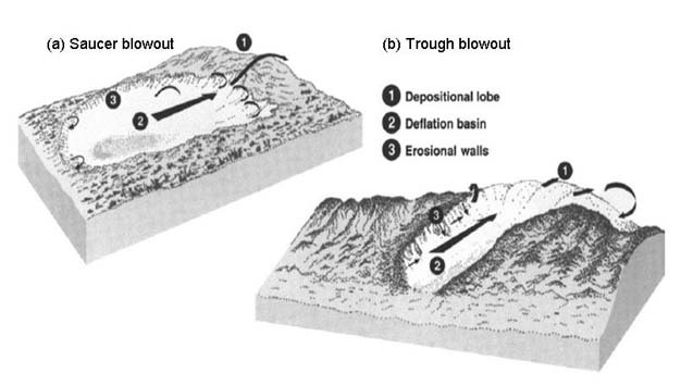
Figure 2
The geomorphological expressions and their characteristic wind flow patterns for (a) saucer blowouts and (b) trough blowouts.
© 2012 Nature Education Reprinted with permission: Hesp & Hyde 1996, Hesp 2002. All rights reserved.
Blowouts
Blowouts commonly occur in the foredune or within and on older vegetated dunes. Blowouts are erosional dune landforms that are typically trough-, bowl-, or saucer-shaped depressions or hollows formed by wind erosion of a pre-existing sandy substrate or dune (Figures 2 and 3, photo 6; Carter et al. 1990, Hesp & Hyde 1996, Hesp 1999). The breaching may occur naturally after erosion of the foredune by storm waves or by funnelling of winds through saddles (lows) in the crest of a high foredune, or wherever there is a reduction in the vegetation cover, thus decreasing the local roughness and increasing the potential for sediment entrainment (Carter et al. 1990, Hesp & Hyde 1996, Hesp 1999, 2002).
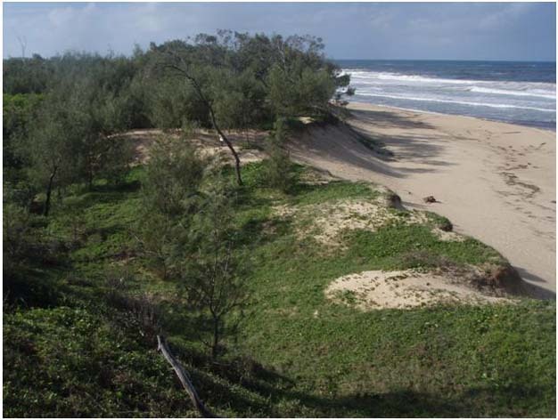
Photograph 6
Blow outs forming in a foredune on the Sunshine Coast of southeast Queensland.
© 2012 Nature Education Courtesy of C. Sloss. All rights reserved.
Over time, there has been an increasing disturbance of dune vegetation associated with human activities such as vegetation clearance for farming and grazing, trampling by farm animals and/or feral and exotic animals, and urban development. Significant disturbance to the vegetation has also been stimulated by increased recreational activities such as trail bikes, dune buggies, and 4WD vehicles, as well as by people walking across the dunes. At exposed sites even a few people occasionally walking across a foredune may disturb the vegetation sufficiently to initiate blowouts.
Once initiated, the subsequent development of a blowout depends on the size of the initial airflow constriction, the height and width of the dune in which the blowout is developing, the degree and type of vegetation cover, the magnitude of regional winds and the degree of exposure to winds from various directions. The morphology of blowouts is characterised by a deflation (erosional) basin floor or depression, lateral erosional walls, and a downwind depositional lobe (Figures 2 and 3, photo 6). The sand eroded by wind from the deflation basin and the adjacent walls of the blowout is deposited immediately downwind to form the depositional lobe (Hesp & Hyde 1996). Although blowouts may be highly variable in their morphology they can be classified into three main types (Carter et al. 1990, Hesp & Hyde 1996, Hesp 1999):
- Saucer blowouts are shallow, semi-circular, ovoid or dish-shaped hollows, that often develop on relatively flat dune terrains. They are characterised by having steep marginal rims and flat to convex downwind depositional lobes (Figure 2).
- Bowl blowouts are deep, semi-circular to circular basins, characterised by long steep inner slopes, and more developed depositional lobes.
- Trough blowouts are generally more narrow, and elongate with deeper deflation floors and basins, steeper and longer erosional lateral walls or slopes, and more pronounced deposition lobes (Figure 2).
The wind flow structure in a blowout may be very complex and highly turbulent. Generally, the wind flow is locally accelerated through the blowout and a high speed jet is formed. Thus, wind speeds in the blowout are significantly greater than outside the blowout and this leads to high rates of sand erosion and transport (Carter et al. 1990, Hesp & Hyde 1996, Hesp 1999). Winds remove sand from the deflation basin and the lateral walls and transport it downwind. The erosional walls are then over-steepened and slumping occurs. This causes the erosional walls to retreat, widening the blowout and supplying sediment to the deflation basin, which is then subsequently transported to the depositional lobe. The wind flow is maximised up the axis of the blowout (middle of the deflation basin) towards the depositional lobe. It experiences rapid flow deceleration over the lobe crest, depositing sediment in a radial fashion over the depositional lobe (Figures 1, 2 and 3). Deflation basins tend to continue to erode until a base level such as water table level or a more consolidated surface is reached (e.g., old soil profiles, an indurated sediment layer), or a lag surface where coarser materials such as pebbles, shell, or pumice may have been concentrated. Many blowouts become larger over time and may evolve into parabolic dunes (see below and Figure 1).
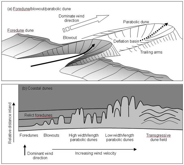
Figure 3
The geomorphological expressions and characteristics of (a) foredune, blowouts, and parabolic dunes, and (b) the main coastal dunes in relation to relative wind velocity and landward progradation.
© 2012 Nature Education Reprinted with permission: Bird 2000. All rights reserved.
Blowouts typically advance through evolutionary stages from erosional notches and hollows, to incipient blowouts, to large blowouts, to re-vegetating and stabilised blowouts. Incipient foredunes commonly form across the throat or entrances of blowouts, eliminating through-flow of beach sand (Carter et al. 1990, Hesp & Hyde 1996, Hesp 1999). Subsequent dune erosion and removal of incipient foredunes can lead to re-activation of the blowouts.
Parabolic dunes
Continued transport of sand through blowouts often results in the development of parabolic dunes. These consist of an actively advancing nose and depositional lobe with two trailing arms that enclose a deflation basin. This produces a characteristic U-shape (i.e., parabolic) or V-shaped dune (Hesp 1999, Figure 2, photo 7). As they develop over a period of time their long axis orientation is closely aligned with that of the dominant wind direction (Bird 2000). Shorter and wider parabolic dunes form where there is a wider range of wind directions (Davis 1980, Bird 2000).
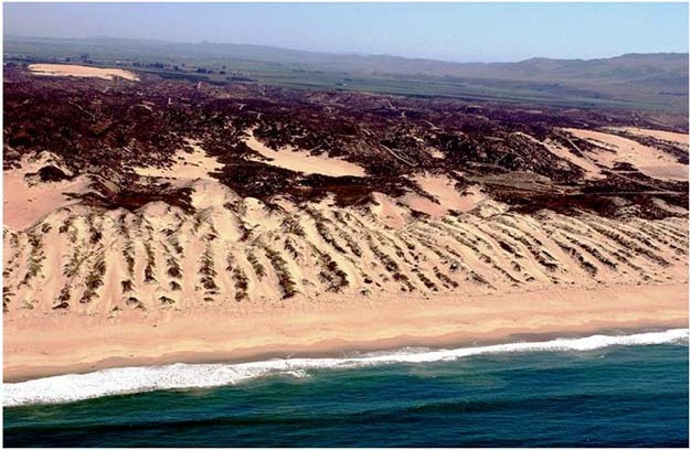
Photograph 7
Parabolic dunes in southern California.
© 2012 Nature Education Reprinted with permission: K. Adelman. All rights reserved.
The parabolic dune shape results from two processes acting contemporaneously. First, sand is eroded off the windward face of the depositional lobe, transported across the lobe, and deposited on the downwind slipface (Figure 2). As the lobe advances, a deflation basin or plain is formed on the upwind side. Second, sand is deposited into vegetation around the margins of the depositional lobe. As the depositional lobe advances downwind, the sediment that was deposited around the margins remains trapped in vegetation and forms the trailing ridges (Figure 2). Deflation basins continue to erode until a base level is reached (Hesp 1991). Rates of parabolic dune advance or migration vary considerably depending on the morphology, slope, and type of terrain the dunes are moving across (e.g., sandy vs. rocky). Other factors that may influence the rate of dune migration include the type and degree of vegetation cover (e.g., woodland vs. grassland), directional variability and velocities of the dominant wind regimes and sediment supply. Parabolic dunes moving across low herbs and grasses display much higher rates of migration, and lower depositional lobes, compared to parabolic dunes migrating into tall forest, which display low migration rates and build upwards and higher against the taller vegetation.
There are two principal sub-types of parabolic dunes: long walled and elliptical types (Figure 2, Hesp 1999).- Long walled parabolic dunes display long trailing ridges and extensive deflation basins. The trailing ridges may range from hundreds of metres to several kilometres in length. They are particularly well developed on relatively flat terrain, in regions of low heath or shrubland, high sand supply, and strong winds (Figure 2).
- Elliptical dunes: Some parabolic dunes display a shorter form, often with more semi-circular or elliptical deflation basins. Multiple phases of dune development results in the elliptical dunes overlapping each other in an imbricate fashion (stacked like roof tiles). They develop in a range of situations including wetter areas, and/or on flat terrain where deflation depths are limited, locations where wind speeds are relatively low and sediment supply remains relatively high, on hummocky or relatively steeper terrain where significant downwind migration is impeded, where there are multi-directional winds, and/or in dense, tall vegetation where the rate of advance is low and migration is impeded (Figure 2).
Transgressive sand sheets and dunefields
Transgressive sand sheets and dunefields are relatively large-scale aeolian sand deposits formed by the downwind and/or alongshore movement of sand over vegetated to semi-vegetated terrain (or transgression of sediment over land; Hesp & Thom 1990). Transgressive sheets are relatively flat to undulating, largely dune-less sheets (like bed sheets), whereas transgressive dunefields comprise various types of dunes on the surface (photo 8). Transgressive dunefields have also been termed mobile dunes, sand drifts, and migratory dunes. Such dunefields may range from quite small (hundreds of metres in alongshore and landward extent) to very large (many kilometres in extent). They may be largely unvegetated, partially vegetated, or completely vegetated (relict). They may be relatively featureless sandsheets, or comprise a variety of dune types ranging from simple barchans (crescentic shaped dunes with wings pointing downwind), transverse dunes (dunes formed at right angles to the wind), barchanoidal transverse dunes, to parabolic dunes.
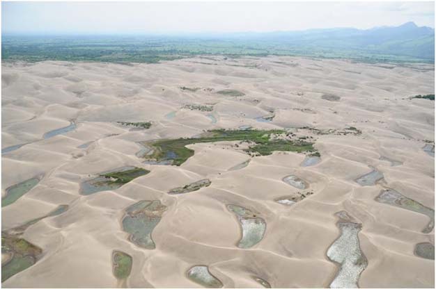
Photograph 8
Transgressive dunefield displaying typical transverse dunes at Veracruz, Mexico.
© 2012 Nature Education Reprinted with permission: M. Martinez. All rights reserved.
In temperate climates they occur when (i) blowouts and/or parabolic dunes increase in size and frequency to the extent that all intervening vegetation is removed or buried, resulting in an unvegetated transgressive sand sheet or dunefield, or (ii) where there is a very large supply of sand and strong winds with little vegetation present and dunes blow inland directly from the beach (Hesp & Thom 1990, Hesp 2002). Such sheets and dunefields may slowly migrate inland, at rates rarely exceeding 10 m per year, burying the pre-existing landscape and often blocking drainage lines to form lakes and swamps at their inner margin. The dunes of all types advance by the deposition of sand on the steep leeward slip face, which usually develops a sinuous slipface with an angle generally between 32°–34° or steeper angles where there is dense vegetation (up to 50°). Therefore, the sand accumulates in steeply dipping beds (cross beds) which dominate the stratification of transgressive dunes (including parabolic dunes).
Summary
Areas of the cost that comprise costal dunes are often areas that undergo significant human modification due to agricultural and urban development, as well as tourism and recreational activities. It is fundamental that understanding of how dunes form and operate is critical when undertaking any development in the coastal zone. Developing this understanding of the process and form relationship of coastal dunes requires an understanding of the controlling factors that are responsible for the various types of coastal dunes. These can be divided into primary dunes, that form from the direct supply of sediment from the beach face, and secondary dunes, formed from the subsequent modification of primary dunes. Haveing a more accurate understanding of the process and geomorphology of coastal dunes helps coastal managers and interested stake holders better manage these dynamic landscapes.
References and Recommended Reading
Bird, E. Coastal Geomorphology: An Introduction. Brisbane, Australia: John Wiley and Son, 2000.
Carter, R. W. G., Hesp, P. A. & Nordstrom, N. F. "Erosional landforms in coastal dunes," in Coastal Dunes: Form and Process, eds. K. F. Nordstrom, N. Psuty & B. Carter (Brisbane, Australia: John Wiley and Son, 1990) 217–252.
Davis, J. L. Geographical Variation in Coastal Development. London, UK: Longman, 1980.
Hesp, P. A. "The beach backshore and beyond," in Handbook of Beach and Shoreface Morphodynamics, ed. A. D. Short (Brisbane, Australia: John Wiley and Son, 1999).
Hesp, P. A. Foredunes and blowouts: Initiation, geomorphology and dynamics. Geomorphology 48, 245–268 (2002).
Hesp, P. A. & Thom, B. G. "Geomorphology and evolution of active transgressive dunefields," in Coastal Dunes: Form and Process, eds. K. F. Nordstrom, N. Psuty & B. Carter (Brisbane, Australia: John Wiley and Son, 1990) 253–288.
Hesp, P. A. & Hyde, R. Flow dynamics and geomorphology of a trough blowout. Sedimentology 43, 505–525 (1996).
Komar, P. D. Beach Processes and Sedimentation. Upper Saddle River, NJ: Prentice Hall, 1976.
Masselink, G. & Hughes, M. G. Introduction to Coastal Processes and Geomorphology. New York, NY: Oxford University Press, 2003.
Short, A. D. & Hesp, P. A. Wave, beach and dune interactions in southeastern Australia. Marine Geology 48, 259–284 (1982).