
 Analysis of a Google map led to the discovery of a Roman villa like this one in Parma, Italy.© Cultural Ministry Emilia Romagna
Using satellite images from Google Maps and Google Earth, an Italian computer programmer has stumbled upon the remains of an ancient villa. Luca Mori was studying maps of the region around his town of Sorbolo, near Parma, when he noticed a prominent, oval, shaded form more than 500 metres long. It was the meander of an ancient river, visible because former watercourses absorb different amounts of moisture from the air than their surroundings do.
His eye was caught by unusual 'rectangular shadows' nearby. Curious, he analysed the image further, and concluded that the lines must represent a buried structure of human origin. Eventually, he traced out what looked like the inner courtyards of a villa.
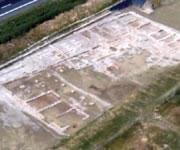
Mori, who describes the finding on his blog, Quellí Della Bassa , contacted archaeologists, including experts at the National Archaeological Museum of Parma. They confirmed the find. At first it was thought to be a Bronze Age village, but an inspection of the site turned up ceramic pieces that indicated it was a Roman villa.
"Mori's research is interesting in its approach," says Manuela Catarsi Dall'Aglio, an archaeologist at the National Archaeological Museum of Parma. He says the find may be similar to a villa the museum is currently excavating at Cannetolo di Fontanellato, which was found during the construction of a high-speed rail network. "Only a scientific, archeological dig will tell," he adds.
The local authorities will have to approve any archaeological digs before they can take place.
