THE PAPER IN BRIEF
• Precise measurements of vertical gradients in gravity can be used to detect inhomogeneities in density under Earth’s surface.
• In a paper in Nature, Stray et al.1 report a practical quantum sensor that uses atom interferometry to measure gravity gradients rapidly, and with high sensitivity.
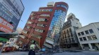
• The sensor is shown to be capable of detecting a tunnel of two-metre-square cross-sectional area under a road surface between two multi-storey buildings, located in an urban environment.
NICOLA POLI: A quantum sense for what lies beneath
Astronomical observations offer us extensive knowledge of what lies above us through both electromagnetic and now gravitational2 signals — even those from sources one billion kilometres away. But, in many ways, we lack the same detailed knowledge of what lies beneath our feet, even a few metres below Earth’s surface. Although several geophysical monitoring techniques exist, most of the time, digging is still the best way to learn about small features under the soil. However, quantum sensors are gaining traction as a viable alternative to classical geophysical sensors.
Read the paper: Quantum sensing for gravity cartography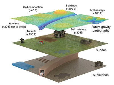
Atomic gravimeters are quantum sensors that use a technique called atom interferometry to measure local gravitational acceleration on the basis of how the gravitational field affects a freely falling cloud of atoms. In a typical configuration, light pulses are used to generate, separate and recombine matter waves (every particle can be described as a wave of matter), allowing them to interfere with each other. The interference pattern detected in a gravimeter is then related to the local gravitational field. Measurements based on this principle can be amazingly precise, but they are still subject to the effects of noise. Atomic gradiometers overcome this problem to some degree by measuring gradients in such gravitational fields, instead of absolute values.
Since their first demonstration as gravimeters and gradiometers more than 20 years ago3, atom interferometers have continued to improve in performance. At the same time, research has focused on how to make such instruments compact and reliable enough to be used outdoors for real-world applications4,5. Stray and colleagues’ instrument is a notable advance in this line of research.
The team developed an hourglass configuration for their gradiometer, with which they performed differential measurements on two clouds of ultracold rubidium atoms, separated vertically by one metre. This configuration provides robust and compact optics that remain properly aligned over a period of several months.
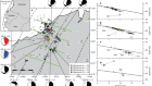
The instrument was capable of non-destructively sensing a large cavity buried beneath Earth’s surface, by measuring the cavity’s tiny gravitational signal alone (Fig. 1a). The sensitivity shown by the device is around 20E (1E is 10–9 per square second) for a measurement taken over 10 minutes, which makes it around 30 times less sensitive than the most sensitive interferometer reported6. However, the authors’ sensor is a step forward in terms of making atom gradiometers practically useful in real-world situations.

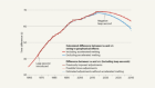
Figure 1 | Gravity cartography in the real world. a, Stray et al.1 developed a quantum sensor that measures vertical gradients of gravity, which can be used to identify variations in density. The device detected an underground tunnel located beneath a road surface between two multi-storey buildings (not shown), which can affect the gradient signal and lead to its attenuation. The expected location of the tunnel on the horizontal axis is marked in red. b, The sensor measured gradients in gravity (in units of E, where 1E is 10–9 per square second) as a function of the sensor’s position relative to the expected location of the tunnel. As well as being at least as accurate as existing commercial tools, the device can acquire data more rapidly and is more portable than other quantum sensors of its kind. (Adapted from Fig. 3 of ref. 1.)
With natural long-term stability and very low sensitivity to environmental effects such as tilt and ground vibrations, together with a lack of mechanical parts, atom gravimeters and gradiometers possess a clear advantage over their classical counterparts. Stray and colleagues’ advance shows that they might soon be more portable and user-friendly, too.
ROMAN PAŠTEKA & PAVOL ZAHOREC: Practical solutions for surface gravity mapping
Our fascination with gravity dates back to the ancient Greeks, and measuring gravitational acceleration was among the first pursuits in modern science. Geophysicists in the eighteenth century used pendula to make such measurements7. But, since then, tools for gravimetry have been the subject of intensive development — from simple spring-based devices, all the way to present-day instruments based on quantum technology. In physical geodesy and applied geophysics, gravimetry measurements are now used to determine the size and shape of Earth, and to identify inhomogeneities in the density of Earth’s interior. Such measurements can reveal near-surface objects or aid the study of the lithosphere, the rocky outer edge of Earth’s structure.
Gradients of gravitational acceleration are more useful than direct measurements in this respect: they are sensitive to shallow density distributions and can detect objects more precisely (Fig. 1b). In terrestrial gravimetric surveys, vertical gradients in gravity can be approximated using measurements from classical spring gravimeters, taken at different heights. But this procedure is time consuming, needing tens of minutes for each data point, and its uncertainty depends on the accuracy of the gravimeter.
Stray et al. estimated that the uncertainty in the measurements taken with their instrument is better than that of commercial gravimeters. Perhaps more importantly, they note that 10 data points can be collected in just 15 minutes. From this point of view, the team’s results, together with those of other research groups8,9, could drastically change applied gravimetry research — lending weight to the authors’ claim that the work constitutes a kind of ‘gravity cartography’.
In general, gravity values (and especially gradients) reflect the distribution of density inhomogeneities below Earth’s surface, but they are also influenced by the effects of terrain and nearby buildings10. The key factor in determining the magnitude of this effect is the nearby topography, which is underestimated in some geophysical studies, and should be taken into account. Gravitational attraction to nearby buildings contributes a smaller, but measurable, addition to the gravity field (and its gradients), and must therefore be estimated and removed from the data using numerical methods, which are well developed.
Although the gravity-gradient method is extremely useful for detecting subsurface objects through density inhomogeneities, its limitations should be recognized. The probability of detecting a subsurface structure depends on the structure’s size and depth, as well as on the degree to which its density differs from that of the surrounding soil or rock environment. From our experience in the detection of subsurface cavities in archaeological prospection11, we can infer the probability of identifying such cavities in common natural conditions when using an instrument with the uncertainty reported by Stray and colleagues.
We estimate that the maximum amplitude of the vertical gravity gradient arising from a tunnel of one metre cross-sectional diameter, lying one metre below Earth’s surface, is more than six times this uncertainty threshold. For a tunnel with a diameter four times wider than this, we calculate that the same maximum amplitude would be measured even if the tunnel were up to four metres below the surface. Such detection ability looks very promising for many engineering and environmental applications.
 Read the paper: Quantum sensing for gravity cartography
 Atomic clouds stabilized to measure dilation of time
 Gravity measurements on chips